Doña Ana County, New Mexico
| Doña Ana County, New Mexico | ||
|---|---|---|
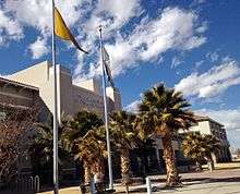 Doña Ana County Government Center | ||
| ||
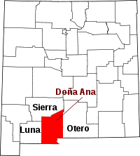 Location in the U.S. state of New Mexico | ||
 New Mexico's location in the U.S. | ||
| Founded | 1852 | |
| Seat | Las Cruces | |
| Largest city | Las Cruces | |
| Area | ||
| • Total | 3,814 sq mi (9,878 km2) | |
| • Land | 3,808 sq mi (9,863 km2) | |
| • Water | 6.9 sq mi (18 km2), 0.2% | |
| Population | ||
| • (2010) | 209,233 | |
| • Density | 55/sq mi (21/km²) | |
| Congressional district | 2nd | |
| Time zone | Mountain: UTC-7/-6 | |
| Website |
www | |

Doña Ana County is a county located in the southern part of the state of New Mexico, in the United States. As of the 2010 census, the population was 209,233,[1] which makes it the second-most populated county in New Mexico. Its county seat is Las Cruces,[2] the second-most populous municipality in New Mexico. Doña Ana is a Spanish name meaning "Madam Anna" and was probably given in honor of some Spanish matron.[3]
Doña Ana County comprises the Las Cruces, NM Metropolitan Statistical Area, which is also included in the El Paso-Las Cruces, TX-NM Combined Statistical Area.
Doña Ana is pronounced Doñana.[4] It borders West Texas and the Mexican state of Chihuahua to the south.
Geography
According to the U.S. Census Bureau, the county has a total area of 3,814 square miles (9,880 km2), of which 3,808 square miles (9,860 km2) is land and 6.9 square miles (18 km2) (0.2%) is covered by water.[5]
The county contains a number of prominent geographical features, most notably the Mesilla Valley (the flood plain of the Rio Grande) going north to south through the center and the Organ Mountains along the county's eastern edge. Other mountain ranges in the county are the Robledo Mountains, Doña Ana Mountains, Sierra de las Uvas, the southern end of the San Andres Mountains, East Potrillo Mountains, and West Potrillo Mountains, as well as two small, isolated mountains, Tortugas (or A) Mountain on the east and Picacho Peak on the west side of Las Cruces. The county also includes one of New Mexico's four large lava fields, the Aden Malpais, and one of the world's largest maare volcanoes, Kilbourne Hole.
Adjacent counties and municipios
- Luna County – west
- Sierra County – north
- Otero County – east
- El Paso County, Texas – southeast
- Ascensión, Chihuahua, Mexico – south
- Juárez, Chihuahua, Mexico – south
National protected areas
- El Camino Real de Tierra Adentro National Historic Trail (part)
- Prehistoric Trackways National Monument
- San Andres National Wildlife Refuge
- White Sands National Monument (part)
Demographics
| Historical population | |||
|---|---|---|---|
| Census | Pop. | %± | |
| 1910 | 12,893 | — | |
| 1920 | 16,548 | 28.3% | |
| 1930 | 27,455 | 65.9% | |
| 1940 | 30,411 | 10.8% | |
| 1950 | 39,557 | 30.1% | |
| 1960 | 59,948 | 51.5% | |
| 1970 | 69,773 | 16.4% | |
| 1980 | 96,340 | 38.1% | |
| 1990 | 135,510 | 40.7% | |
| 2000 | 174,682 | 28.9% | |
| 2010 | 209,233 | 19.8% | |
| Est. 2015 | 214,295 | [6] | 2.4% |
| U.S. Decennial Census[7] 1790-1960[8] 1900-1990[9] 1990-2000[10] 2010-2014[1] | |||
2000 census
As of the census[11] of 2000, there were 174,682 people, 59,556 households, and 42,939 families residing in the county. The population density was 46 people per square mile (18/km²). There were 65,210 housing units at an average density of 17 per square mile (7/km²). The racial makeup of the county was 67.82% White, 1.56% Black or African American, 1.48% Native American, 0.76% Asian, 0.07% Pacific Islander, 24.74% from other races, and 3.58% from two or more races. 63.35% of the population were Hispanic or Latino of any race.
There were 59,556 households out of which 38.40% had children under the age of 18 living with them, 52.40% were married couples living together, 14.70% had a female householder with no husband present, and 27.90% were non-families. 21.30% of all households were made up of individuals and 6.90% had someone living alone who was 65 years of age or older. The average household size was 2.85 and the average family size was 3.36.
In the county the population was spread out with 29.70% under the age of 18, 13.30% from 18 to 24, 27.10% from 25 to 44, 19.30% from 45 to 64, and 10.60% who were 65 years of age or older. The median age was 30 years. For every 100 females there were 96.50 males. For every 100 females age 18 and over, there were 93.50 males.
The median income for a household in the county was $29,808, and the median income for a family was $33,576. Males had a median income of $27,215 versus $20,883 for females. The per capita income for the county was $13,999. 25.40% of the population and 20.20% of families were below the poverty line. Out of the total people living in poverty, 34.40% are under the age of 18 and 12.70% are 65 or older.
2010 census
As of the 2010 United States Census, there were 209,233 people, 75,532 households, and 51,863 families residing in the county.[12] The population density was 55.0 inhabitants per square mile (21.2/km2). There were 81,492 housing units at an average density of 21.4 per square mile (8.3/km2).[13] The racial makeup of the county was 74.1% white, 1.7% black or African American, 1.5% American Indian, 1.1% Asian, 0.1% Pacific islander, 18.5% from other races, and 3.0% from two or more races. Those of Hispanic or Latino origin made up 65.7% of the population.[12] In terms of ancestry, 7.3% were German, and 2.2% were American.[14]
Of the 75,532 households, 37.4% had children under the age of 18 living with them, 46.8% were married couples living together, 16.0% had a female householder with no husband present, 31.3% were non-families, and 24.2% of all households were made up of individuals. The average household size was 2.71 and the average family size was 3.25. The median age was 32.4 years.[12]
The median income for a household in the county was $36,657 and the median income for a family was $43,184. Males had a median income of $33,510 versus $25,217 for females. The per capita income for the county was $18,315. About 20.1% of families and 24.5% of the population were below the poverty line, including 34.8% of those under age 18 and 13.6% of those age 65 or over.[15]
Politics
| Year | GOP | DEM | Others |
|---|---|---|---|
| 2008 | 40.5% 28,068 | 58.1% 40,282 | 1.3% 930 |
| 2004 | 47.7% 29,548 | 51.3% 31,762 | 1.0% 650 |
| 2000 | 45.6% 21,263 | 51.3% 23,912 | 3.2% 1,478 |
| 1996 | 40.3% 17,541 | 52.3% 22,766 | 7.5% 3,257 |
| 1992 | 36.9% 16,308 | 45.0% 19,894 | 18.2% 8,015 |
| 1988 | 51.7% 21,582 | 47.0% 19,608 | 1.3% 557 |
| 1984 | 60.9% 22,153 | 38.1% 13,878 | 1.0% 362 |
| 1980 | 53.9% 15,539 | 37.6% 10,839 | 8.5% 2,442 |
| 1976 | 53.1% 13,888 | 46.0% 12,036 | 0.9% 233 |
| 1972 | 59.8% 14,562 | 38.6% 9,416 | 1.6% 388 |
| 1968 | 54.1% 10,824 | 38.3% 7,658 | 7.6% 1,508 |
| 1964 | 40.3% 7,280 | 59.4% 10,748 | 0.3% 57 |
| 1960 | 46.5% 7,789 | 53.1% 8,905 | 0.4% 61 |
Doña Ana is a Democratic-leaning county in Presidential and Congressional elections. Since 1920, Doña Ana has voted for the candidate who also won statewide, the only exception being in 2004 when Democrat John Kerry won Doña Ana 51–48%, while Republican George W. Bush won statewide 50–49%. The last Republican to win a majority in the county was George H.W. Bush in 1988. In 2008, Democrat Barack Obama won 58% of the county's vote.
Doña Ana is part of New Mexico's 2nd congressional district, which is held by Republican Steve Pearce. In the State Senate Doña Ana is part of the 31st, 36th, 37th, 38th, and 40th Senate districts, which are held by Democrats Cynthia Nava, Mary Jane Garcia, Stephen Fischmann, Mary Kay Papen, and Republican Bill Burt, respectively. In the State House Doña Ana is part of the 33rd, 34th, 35th, and 52nd House districts, which are held by Democrats Joni Gutierrez, Mary Helen Garcia, Antonio Lujan, and Joseph Cervantes, respectively, the 37th and 53rd House districts, which are held by Republicans Terry McMillan and Ricky Little, respectively, and the 36th House district, which is held by Independent Andrew Nunez. Current County Commissioners are as follows: Billy Garrett (District 1), Dr. David Garcia (District 2), Ben Rawson (District 3), Wayne Hancock (District 4), and Leticia Duarte-Benavidez (District 5).
In January 2012, a Federal court awarded former County prisoner Stephen Slevin a $22 million award[16] for inhumane treatment and for keeping him jailed for 2 years without a trial.[17][18] In a radio interview on the Canadian Broadcasting Corporation program As It Happens broadcast February 7, 2012, Slevin's lawyer indicated that he was arrested for "DWI". During his incarceration, Slevin was placed in solitary confinement. When his health deteriorated, Slevin was removed to a hospital, but after two weeks in the hospital, he was returned to solitary confinement. The lawyer stated that pictures taken before and after Slevin's time in jail were key to the trial's outcome.[19] The District Attorney for the 3rd Judicial District in Doña Ana County during the 2005 - 2007 indefinite detention without trial of Mr. Slevin was Susana Martinez, the current Governor of New Mexico.[20]
In August 2013, County Clerk Lynn Ellins announced he will begin granting marriage licenses to same-sex couples. Ellins said in a statement explaining his decision:[21]
After careful review of New Mexico's laws it is clear that the state's marriage statutes are gender neutral and do not expressly prohibit Doña Ana County from issuing marriage licenses to same-gender couples. Any further denial of marriage licenses to these couples violates the United States and New Mexico Constitution and the New Mexico Human Rights Act. Doña Ana County is upholding New Mexico law by issuing these marriage licenses, and I see no reason to make committed couples in Doña Ana County wait another minute to marry.
Several Republican state legislators vowed to file suit against Ellins in a bid to halt the licenses from being issued.[22]
Communities

Cities
- Las Cruces (county seat)
- Sunland Park
Towns
Village
Census-designated places
See also
References
- 1 2 "State & County QuickFacts". United States Census Bureau. Retrieved September 29, 2013.
- ↑ "Find a County". National Association of Counties. Retrieved June 7, 2011.
- ↑ Gannett, Henry (1905). The Origin of Certain Place Names in the United States. Govt. Print. Off. p. 107.
- ↑ Spellenberg, Richard (May 10, 2002). "CLEOME MULTICAULIS ON THE RÍO GRANDE IN SOUTHERN NEW MEXICO?" (PDF). The New Mexico Botanist. apparently published by the [then so called] (as of 2002) "Range Science Herbarium and Cooperative Extension Service, College of Agriculture and Home Economics, New Mexico State University" -- which seems to correspond to what is now -- (as of 2014) -- called the "Range Science Herbarium": http://aces.nmsu.edu/academics/rangescienceherbarium/ of the NMSU "College of Agricultural, Consumer and Environmental Sciences" (but, "see also": the "Cooperative Extension Service": http://extension.nmsu.edu/).
(quote:) Wright spelled fonetically, and didn’t spell presisely, and Doñana is the proper pronunciation for Doña Ana. So we can remove that remote possibility.
External link in|publisher=(help) - ↑ "2010 Census Gazetteer Files". United States Census Bureau. August 22, 2012. Retrieved January 1, 2015.
- ↑ "County Totals Dataset: Population, Population Change and Estimated Components of Population Change: April 1, 2010 to July 1, 2015". Retrieved July 2, 2016.
- ↑ "U.S. Decennial Census". United States Census Bureau. Retrieved January 1, 2015.
- ↑ "Historical Census Browser". University of Virginia Library. Retrieved January 1, 2015.
- ↑ "Population of Counties by Decennial Census: 1900 to 1990". United States Census Bureau. Retrieved January 1, 2015.
- ↑ "Census 2000 PHC-T-4. Ranking Tables for Counties: 1990 and 2000" (PDF). United States Census Bureau. Retrieved January 1, 2015.
- ↑ "American FactFinder". United States Census Bureau. Retrieved January 31, 2008.
- 1 2 3 "DP-1 Profile of General Population and Housing Characteristics: 2010 Demographic Profile Data". United States Census Bureau. Retrieved 2016-01-24.
- ↑ "Population, Housing Units, Area, and Density: 2010 - County". United States Census Bureau. Retrieved 2016-01-24.
- ↑ "DP02 SELECTED SOCIAL CHARACTERISTICS IN THE UNITED STATES – 2006-2010 American Community Survey 5-Year Estimates". United States Census Bureau. Retrieved 2016-01-24.
- ↑ "DP03 SELECTED ECONOMIC CHARACTERISTICS – 2006-2010 American Community Survey 5-Year Estimates". United States Census Bureau. Retrieved 2016-01-24.
- ↑ Stephen Slevin vs. Board of Commissioners for the County of Doña Ana, et al. "Special Verdict Form." United States District Court, Santa Fe, NM. January 24, 2012
- ↑ "Lonely hell of long forgotten prisoner Stephen Slevin". The Telegraph (AU). January 29, 2012. Retrieved January 28, 2012.
- ↑ Mears, Bill (January 25, 2012). "Former inmate wins $22 million over 'forgotten' solitary confinement". CNN. Retrieved January 28, 2012.
- ↑ Canadian Broadcasting Corporation program As It Happens, February 7, 2012
- ↑ "Meet the Governor." New Mexico Office of the Governor Susana Martinez. January 29, 2012.
- ↑ "ELLINS: DOÑA ANA COUNTY ISSUING SAME-GENDER MARRIAGE LICENSES". Doña Ana County. August 21, 2013. Retrieved August 26, 2013.
- ↑ "GOP to challenge state's gay marriages". Santa Fe New Mexican. August 22, 2013. Retrieved August 26, 2013.
External links
| Wikimedia Commons has media related to Doña Ana County, New Mexico. |
 |
Sierra County | | ||
| Luna County | |
Otero County | ||
| ||||
| | ||||
| Ascensión, Chihuahua, Mexico and Juárez, Chihuahua, Mexico | El Paso County, Texas |
| Las Cruces, New Mexico | |
|---|---|
| Suburbs | |
| Doña Ana | Mesilla | University Park | |
| Doña Ana County | |
| New Mexico State University |
Municipalities and communities of Doña Ana County, New Mexico, United States | ||
|---|---|---|
| Cities | | |
| Town | ||
| Village | ||
| CDPs | ||
| Ghost towns | ||
Santa Fe (capital) | |
| Topics |
|
| Society | |
| Regions | |
| Cities | |
| Counties | |
Coordinates: 32°18′44″N 106°46′42″W / 32.31222°N 106.77833°W