Langley, British Columbia (city)
| Langley | |||
|---|---|---|---|
| City | |||
| City of Langley | |||
|
Langley City Hall | |||
| |||
| Motto: "Strength of Purpose, Spirit of Community" | |||
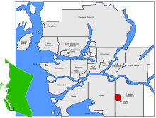 Location of Langley in British Columbia | |||
| Coordinates: 49°06′14″N 122°39′24″W / 49.10389°N 122.65667°W | |||
| Country |
| ||
| Province |
| ||
| Region | Lower Mainland | ||
| Regional district | Metro Vancouver | ||
| Incorporated | March 15, 1955 | ||
| Government | |||
| • Governing body | Langley City Council | ||
| • Mayor | Ted Schaffer | ||
| • Councillors |
Paul Albrecht Jack Arnold Dave Hall Gayle Martin Rudy Storteboom Val van den Broek | ||
| • MP | John Aldag (Lib.) | ||
| • MLA | Mary Polak (Lib.) | ||
| Area | |||
| • City | 10.22 km2 (3.95 sq mi) | ||
| Elevation | 15 m (49 ft) | ||
| Population (2011) | |||
| • City | 25,081 | ||
| • Density | 2,454.6/km2 (6,357/sq mi) | ||
| • Metro | 104,177 | ||
| Time zone | PST (UTC-8) | ||
| Postal code | V1M – V4W | ||
| Area code(s) | 604 | ||
| Highways |
| ||
| Website | City of Langley | ||
.jpg)


The City of Langley is a municipality in the Greater Vancouver Regional District, aka Metro Vancouver. It lies directly east of the City of Surrey, adjacent to Cloverdale, and surrounded on the north, east and south by Township of Langley.
History
Early European settlement in the area was known as "Innes Corners" (after homesteader Adam Innes); in 1911, the area became known as "Langley Prairie", part of the Township of Langley a.k.a. Langley Township since 1873. Owing to its more urban development and related needs (such as street lights), the City of Langley decided to separate and incorporate as a separate municipality on March 15, 1955.[1]
City Plan

Road Network
Langley City follows the same block system as its neighbouring Township of Langley as well as other Districts in the Fraser Valley, where Streets run North-South, and Avenues run East-West.
Development Barriers
Many natural and artificial barriers prevent Langley City from following a complete tidy grid:
- The land governed by the City is not a rectangle but an uneven shape with "cut-out" corners.
- Fraser Highway intersects the City at an approximate 45 degree angle North West to South East, mirrored by Glover Road which enters the city North East to South West.
- The Nicomekl River flows through the middle of the city East to West.
- Railroad tracks run across the north of the City.
This has affected development in a number of ways, for example the Langley Bypass turns 45 degrees in the North-West, tracing the boundary outline since it was constructed by the City and could not go over the boundary into the Langley Township. Many streets come to an abrupt halt when reaching the river and continue on the other side without a connecting bridge. Roads such as Douglas Crescent, Logan Avenue, and Eastleigh Crescent parallel the 45 degree angles of Fraser Highway and Glover Road, almost proposing an alternative grid at an angle which conflicts with the grid in place. Even Grade Crescent, which is much further south than these roads, follows this same angle, demonstrating the impact Fraser Highway had on the development of Langley.
Downtown
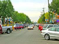
Langley City's Downtown was developed around Old Yale Road, which later on became Fraser Highway. Until 1964, Fraser Highway was part of the Trans-Canada Highway network - this major route attracted many businesses to the area.[1]
Today, with the Trans-Canada Highway now in the north of the Langley Township, the downtown is more pedestrian oriented. Where Fraser Highway goes through the downtown it is reduced to a single lane of traffic in one direction to limit traffic flow. This stretch is often affectionately referred to by residents as "The One-Way" and is lined with restaurants and shops either side, making it a popular retail centre in the city. Douglas Park is also near this area in the downtown, and is seen as main park in the city, frequently being used for events and shows.
.jpg)
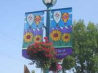
In Summer 2013, McBurney Plaza opened to the public replacing McBurney Lane (previously used as a parking lot).[2] This area connects Fraser Highway and Douglas Park with a pedestrian boulevard, providing outdoor space for cafes and a space the city can use for street performance and other civic events.
Just outside this downtown centre are strip malls and a number of low rise apartment buildings. Most detached housing remains outside the downtown area.
Parks
There are over 17 public parks in this city. They range from small neighbourhood adventure playgrounds, to larger parks with nature trails, wildlife, and various sporting fields and equipment. A few of the more popular parks are listed below.
Brydon Park
This park contains an adventure playground, a paved play area for ball hockey and basketball, an intermediate soccer field, and a softball diamond. Public washrooms are available. Brydon Lagoon is south of the park and has a peaceful perimeter walk around the lagoon where one may observe wildfowl and turtles.[3]
City Park
This park features Al Anderson Memorial Pool, a children’s waterpark and playground, a lacrosse box, twelve picnic tables, and public washrooms. A covered picnic shelter that can accommodate up to 75 people is available and can be booked for a picnic.[3]
Dog Off-Leash Park
This is an 18-acre, fully fenced area with a perimeter walking path. Dogs and their owners can meet and enjoy a large open space for walking and playing. There is also a drinking fountain designed for both dogs and people.[3]
.jpg)
Douglas Park
Douglas Park is located at the intersection of Douglas Crescent and 206th Street in Langley, British Columbia, Canada.[4]
The park contains an adventure playground, two tennis courts, a water park (seasonal), bowling green, sports box, basketball hoops and public washrooms. It also has an outdoor covered performance platform called "Langley Spirit Square". Langley Spirit Square is the site of an annual Shakespeare performance, "Shakespeare in the Valley."
Douglas Recreation Centre, situated in the park, offers many programs for the citizens of Langley and is also available for rentals such as wedding receptions or banquets and other events.
In 1965, there were plans to build a library in the park, but public opposition forced the library be built elsewhere.[5] In 1971, Langley's city council had plans to install a Chinese garden in the park, but this was never carried out.[6] In 1982, a day care centre in the park was replaced by a bowls meeting house and a bowling green was established adjacent to it.[7]
Douglas Park is the main park in the City of Langley for events, festivals and other civic activities. Featuring a permanent stage, the park is equipped for live performance of music, theatre and other arts.[3]
Linwood Park
This park contains a ball diamond, senior soccer field and a wheelchair accessible playground. Public washrooms are available.[3]
Nicomekl Park
This park is has a suitable parking area and is the starting point to enter the floodplain and various walking trails.[3]
Penzer Bike Park
This park has dirt jumps for mountain bike enthusiasts and is extremely popular with riders from beginner to expert. A nature Trail passes through the park and is for all ages.
Rotary Centennial Park
This park contains a playground, ball diamond, senior soccer field, display garden beds, and public washrooms. A paved walking path follows the perimeter, and the facilities are wheelchair accessible.[3]
Sendall Gardens
This park contains botanical gardens that feature 3.67 acres of beautiful and unique plants, shrubs and trees. A nature trail passes through this park, and there are two duck ponds for viewing. Public washrooms are available. There are several varieties of wildfowl to observe, including geese and ducks. This park is a popular location for wedding and family photos. The tropical greenhouse offers a wide variety of colourful exotic plants and is open to the public April 1 to October 1.[3]
Sports
The Langley Rams of the British Columbia Conference of the Canadian Junior Football League are based at the MacLeod Stadium in the Township of Langley.
The Langley Rivermen of the British Columbia Hockey League, the Vancouver Stealth of the National Lacrosse League and the Vancouver Giants of the Western Hockey League are based at the Langley Events Centre in the Township of Langley.
The Langley Blaze of the Premier Baseball League are based at McLeod Park.
A local Little League baseball team represented Canada in the 2011 Little League World Series in Williamsport, PA.
Brett Lawrie, third baseman for the Oakland Athletics is from Langley, as is professional cyclist Svein Tuft of the Greenedge Cycling Team.
The Langley Thunder are a Senior A team in the Western Lacrosse Association, part of the Canadian Lacrosse Association.
Education
School District 35 Langley operates public schools.
The City of Langley is home to six Elementary schools and one Middle school, H. D. Stafford Middle School. Five major high schools are located in the surrounding area; Brookswood Secondary School, Langley Secondary School, D. W. Poppy Secondary School, Walnut Grove Secondary School, & R. E. Mountain Secondary School. They are located in the Township of Langley.
The Conseil scolaire francophone de la Colombie-Britannique operates one Francophone school: école des Voyageurs primary school.[8]
Kwantlen Polytechnic University also has a campus in Langley.
Transportation
The City of Langley is served by The South Coast British Columbia Transportation Authority (Also known as TransLink). TransLink operates the regional transportation network and is also the regional transportation authority.
Langley is served by several regular bus routes, and five "community shuttle" routes operating smaller capacity mini-buses.
The Fraser Highway is one of the major east-west corridors servicing the City of Langley and the Township of Langley. The "502" bus route operates on a 15-minute headway (7–10 minutes during rush hour) from the Surrey Central Station in north Surrey to the Langley Centre bus loop in the City of Langley via Fraser Highway. The "503" Express service, launched on June 23, 2014, provides half-hourly express service between Surrey Central Station and Langley Centre and local service through the Township of Langley into Aldergrove.[9]
The other major routes include the "320 Surrey Central Station" (via Cloverdale), "341 Guildford" (via Cloverdale, & Newton), the "364 Scottsdale" (via 64th avenue), the "501/590 Surrey Central Station" (via 200th, Walnut Grove, during morning rush hour the route originates in Brookswood as the "590", and runs express past Guildford Exchange. In the PM rush hour, there is a bus every 15 minutes from Surrey Central, where every other bus is a "590" to Langley South), and then there's the "595" to Maple Ridge. The "595" bus runs express limited stop service along 200th street, and across the Golden Ears Bridge.
As of December 1, 2012,[10] TransLink had created a new "555 Port Mann Express / Lougheed Town Centre Station" rapid bus service which operates between Carvolth Exchange (in Langley) and Lougheed Town Centre Station[11] (in Burnaby, British Columbia) via Highway 1, with just one stop along the way in Surrey. This bus takes approximately 20 minutes from start to finish in one direction. It runs frequently; approximately every 7–10 minutes during peak times, and every 30 minutes during off-peak times.
Arts and culture
Langley is the home of a very large annual car show, the "Langley Cruise-In".[12] This event is held each September. Langley is also home to the Arts Alive Festival in August, and the Langley Ukulele Ensemble.
Government
Langley City Council has seats for one mayor and six councilors. Each serves a 3-year term and attends council meetings on a bi-weekly basis. Other governmental departments include the Office of the Chief Administrative Officer, Corporate Services, Development Services & Economic Development, Engineering, Parks & Environment, Recreation, Culture and Community Services, and the Langley City Fire Rescue Service. The City of Langley has a joint RCMP detachment with the township of Langley.
Langley is also a key component in the Canadian federal electoral district of the same name, which was formed in 2004. The Member of Parliament for the constituency is Conservative Mark Warawa.
Climate
| Climate data for Langley | |||||||||||||
|---|---|---|---|---|---|---|---|---|---|---|---|---|---|
| Month | Jan | Feb | Mar | Apr | May | Jun | Jul | Aug | Sep | Oct | Nov | Dec | Year |
| Record high °C (°F) | 15 (59) |
18.5 (65.3) |
20 (68) |
24.4 (75.9) |
34 (93) |
32.2 (90) |
35.6 (96.1) |
36.1 (97) |
33.3 (91.9) |
27.5 (81.5) |
19 (66) |
16.1 (61) |
36.1 (97) |
| Average high °C (°F) | 5 (41) |
7.6 (45.7) |
10.5 (50.9) |
13.3 (55.9) |
16.8 (62.2) |
19.3 (66.7) |
22.6 (72.7) |
22.8 (73) |
19.6 (67.3) |
14.1 (57.4) |
8.1 (46.6) |
5.3 (41.5) |
13.7 (56.7) |
| Average low °C (°F) | −0.6 (30.9) |
1.2 (34.2) |
2.2 (36) |
3.8 (38.8) |
6.7 (44.1) |
9.2 (48.6) |
10.8 (51.4) |
11.1 (52) |
8.8 (47.8) |
5.6 (42.1) |
2.1 (35.8) |
0.1 (32.2) |
5.1 (41.2) |
| Record low °C (°F) | −14 (7) |
−12 (10) |
−8.3 (17.1) |
−2.8 (27) |
−0.6 (30.9) |
1.7 (35.1) |
3.9 (39) |
3.3 (37.9) |
−1.7 (28.9) |
−7 (19) |
−16 (3) |
−19.4 (−2.9) |
−19.4 (−2.9) |
| Average precipitation mm (inches) | 176 (6.93) |
172.1 (6.776) |
135.2 (5.323) |
102.7 (4.043) |
82.8 (3.26) |
72.9 (2.87) |
52.7 (2.075) |
56.4 (2.22) |
76.4 (3.008) |
141 (5.55) |
207.5 (8.169) |
211.3 (8.319) |
1,486.9 (58.539) |
| Source: Environment Canada[13] | |||||||||||||
Demographics
| Canada 2006 census | Population | Of total population | |
|---|---|---|---|
| Visible minority group[14] | South Asian | 250 | 1.1% |
| Chinese | 545 | 2.3% | |
| Black | 260 | 1.1% | |
| Filipino | 360 | 1.5% | |
| Latin American | 255 | 1.1% | |
| Arab | 10 | 0% | |
| Southeast Asian | 205 | 0.9% | |
| West Asian | 40 | 0.2% | |
| Korean | 480 | 2.1% | |
| Japanese | 90 | 0.4% | |
| Other visible minority | 20 | 0.1% | |
| Mixed visible minority | 55 | 0.2% | |
| Total | 2,565 | 11% | |
| Aboriginal group[15] | First Nations | 405 | 1.7% |
| Métis | 425 | 1.8% | |
| Inuit | 0 | 0% | |
| Total | 850 | 3.6% | |
| White | 19,920 | 85.4% | |
| Total population | 23,335 | 100% | |
Infrastructure
Langley's community facilities include:
- Al Anderson Memorial – 25 metre public swimming pool
- Douglas Recreation Centre
- Langley Library
- Cascades Casino, Coast Hotel & Convention Centre
- Numerous parks
Neighbourhoods
The City of Langley's Community Profile[16] identifies six neighbourhoods based on elementary school catchment area: Nicomekl, Douglas, Simonds, Blacklock, Alice Brown and Uplands.
Notable people
- Amanda Crew, actress
- Brett Lawrie, baseball player for the Chicago White Sox
- J. Jill Robinson, author of fiction and creative nonfiction
- Brian Smith, the guitarist for the rock band Trooper.
- Dallas Smith, the lead vocalist for the rock band Default and country music singer.
- Tom Thacker, guitarist and vocalist with Gob and Sum 41
References
- 1 2 City of Langley. History of Langley
- ↑ Lane Storyboards
- 1 2 3 4 5 6 7 8 City of Langley Parks and Trails Website
- ↑ Don Young; Marjorie Young (1999). Adventure Guide to the Pacific Northwest. Hunter Publishing. p. 372. ISBN 1556508441.
- ↑ "Group Protests Park Library Site". The Vancouver Sun. November 15, 1965. p. 33.
- ↑ "Mill rate retained". The Vancouver Sun. April 12, 1971. p. 8.
- ↑ "Club 'extravagant'". The Vancouver Sun. November 16, 1982. p. D11.
- ↑ "Carte des écoles." Conseil scolaire francophone de la Colombie-Britannique. Retrieved on 22 January 2015.
- ↑ "The Buzzer - June 13, 2014 edition". TransLink. Retrieved 25 August 2015.
- ↑ http://buzzer.translink.ca/2012/11/new-555-bus-rides-over-the-port-mann-on-dec-1-2012-and-more-bus-changes-coming-dec-3/. Missing or empty
|title=(help) - ↑ "#555 Lougheed Station/Carvolth Exchange Schedule" (PDF). TransLink. Retrieved 25 August 2015.
- ↑ Langley Cruise-In
- ↑ Environment Canada—Canadian Climate Normals 1971–2000, accessed July 10, 2009
- ↑ , Community Profiles from the 2006 Census, Statistics Canada - Census Subdivision
- ↑ , Aboriginal Peoples - Data table
- ↑ City of Langley Community Profile
- From Prairie to City: A History of the City of Langley, Warren F. Sommer, 1995.
Neighbouring communities
 |
Fleetwood (City of Surrey) |
Walnut Grove, Port Kells (Township of Langley) | Milner, Fort Langley (Township of Langley) |
|
| Cloverdale (City of Surrey) |
|
Township of Langley | ||
| ||||
| | ||||
| Township of Langley | Aldergrove (Township of Langley) |
Municipalities of Metro Vancouver | |
|---|---|
| Population over 500,000 | |
| Population over 100,000 | |
| Population over 50,000 | |
| Population over 10,000 | |
| Population under 10,000 | |
| Unincorporated areas | |
| |
| Subdivisions | 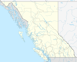 | |
|---|---|---|
| Communities | ||
| Metro areas and agglomerations | ||
| Cities |
| |
| ||
External links
| Wikimedia Commons has media related to Langley, British Columbia (city). |
Coordinates: 49°06′15″N 122°39′27″W / 49.1041°N 122.65758°W