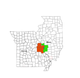
| St. Louis Landmarks[2] |
Location |
Construction[2][3] |
Demolition[2] |
NRHP[4] |
NHL[3] |
Image |
| A 19th Century House |
911 N. Tucker Street
38°38′05″N 90°11′46″W / 38.6348°N 90.1960°W / 38.6348; -90.1960 (A 19th Century House) |
c. 1840 |
|
|
|
|
| Ackley Building |
511 Washington Ave
38°37′48″N 90°11′19″W / 38.6301°N 90.1886°W / 38.6301; -90.1886 (Ackley Building) |
1876 |
|
|
|
|
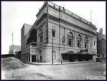
| Ambassador Theatre |
11th and Locust |
1926 |
1996 |
000000001983-03-29-0000March 29, 1983 |
|
|
| Anheuser-Busch Brewery |
711 Pestalozzi
38°35′55″N 90°12′54″W / 38.5985°N 90.2150°W / 38.5985; -90.2150 (Anheuser-Busch Brewery) |
1859 |
|
|
000000001966-11-13-0000November 13, 1966 |
.jpg) |
| Arcade Building |
810 Olive
38°37′43″N 90°11′34″W / 38.6287°N 90.1929°W / 38.6287; -90.1929 (Arcade Building) |
1919 |
|
000000002003-03-23-0000March 23, 2003 |
|
 |
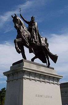
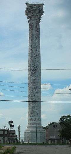
| Apotheosis of St. Louis |
1 Fine Arts Drive (Forest Park)
38°38′23″N 90°17′39″W / 38.6398°N 90.2941°W / 38.6398; -90.2941 (Apotheosis of St. Louis) |
1906 |
|
|
|
 |
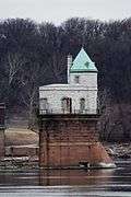
| Ashley Street Power House |
Ashley Street and Mississippi River
38°38′09″N 90°10′53″W / 38.6357°N 90.1815°W / 38.6357; -90.1815 (Ashley Street Power House) |
1902 |
|
|
|
|
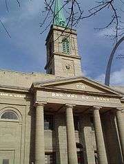
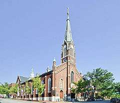
Basilica of St. Louis, King of France
(Old Cathedral) |
209 Walnut Street
38°37′26″N 90°11′15″W / 38.6239°N 90.1876°W / 38.6239; -90.1876 (Basilica of St. Louis (Old Cathedral)) |
1834 |
|
|
|
 |
| Bee Hat Building |
1021 Washington Ave
38°37′54″N 90°11′41″W / 38.6317°N 90.1946°W / 38.6317; -90.1946 (Bee Hat Building) |
1905 |
|
|
|
|
| Bell Telephone Building |
920 Olive
38°37′45″N 90°11′40″W / 38.6291°N 90.1945°W / 38.6291; -90.1945 (Bell Telephone Building) |
1889 |
|
000000001999-08-05-0000August 5, 1999 |
|
.jpg) |
| Bethlehem Lutheran Church |
2153 Salisbury
38°39′33″N 90°12′19″W / 38.6592°N 90.2054°W / 38.6592; -90.2054 (Bethlehem Lutheran Church) |
1895 |
|
|
|
|
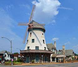
| Bevo Mill |
4749 Gravois
38°34′54″N 90°16′01″W / 38.5817°N 90.2670°W / 38.5817; -90.2670 (Bevo Mill) |
1917 |
|
|
|
 |
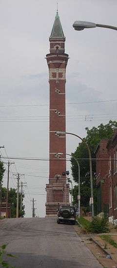
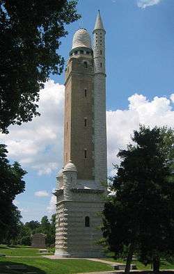
| Bissell Water Tower |
Bissell and Blair Avenues
38°40′13″N 90°12′20″W / 38.6704°N 90.2056°W / 38.6704; -90.2056 (Bissell Water Tower) |
1886 |
|
000000001970-06-05-0000June 5, 1970 |
|
 |
| Bissell House |
4426 Randall
38°40′13″N 90°12′12″W / 38.6704°N 90.2034°W / 38.6704; -90.2034 (Lewis Bissell House) |
1823 |
|
|
|
|
| Broadway store buildings |
7121–7129 S. Broadway
38°33′02″N 90°15′16″W / 38.5505°N 90.2545°W / 38.5505; -90.2545 (Broadway store buildings) |
1850 |
|
|
|
|
| Jack Buck Statue |
Busch Stadium
38°37′25″N 90°11′34″W / 38.6236°N 90.1927°W / 38.6236; -90.1927 (Jack Buck Statue) |
1998 |
|
|
|
|
| Cabanne House |
115 Union Blvd (Forest Park)
38°38′40″N 90°16′31″W / 38.6445°N 90.2754°W / 38.6445; -90.2754 (Cabanne House (Park Keeper's House)) |
1875 |
|
|
|
 |
| Campbell House Museum |
1508 Locust
38°37′54″N 90°12′06″W / 38.6316°N 90.2018°W / 38.6316; -90.2018 (Campbell House Museum) |
1851 |
|
|
|
 |
| Carondelet Branch Public Library |
6800 Michigan
38°33′17″N 90°15′15″W / 38.5548°N 90.2542°W / 38.5548; -90.2542 (Carondelet Branch Public Library) |
1907 |
|
|
|
|
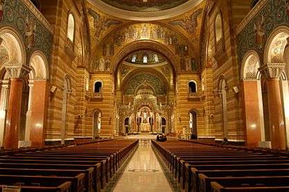
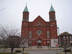
Cathedral Basilica of Saint Louis
(New Cathedral) |
4431 Lindell Blvd
38°38′32″N 90°15′17″W / 38.6421°N 90.2548°W / 38.6421; -90.2548 (Cathedral Basilica of St. Louis (New Cathedral)) |
1914 |
|
|
|
 |
| Centenary Methodist Episcopal Church, South |
N. 16th & Pine Streets
38°37′49″N 90°12′13″W / 38.6304°N 90.2036°W / 38.6304; -90.2036 (Centenary Methodist Episcopal Church) |
1869 |
|
|
|
|
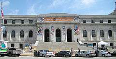
| Central Library Branch |
1301 Olive
38°37′50″N 90°11′58″W / 38.6306°N 90.1995°W / 38.6306; -90.1995 (St. Louis Public Library (Central Library Branch)) |
1912 |
|
|
|
 |
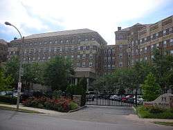
| Chase Park Plaza Hotel |
212 N. Kingshighway
38°38′42″N 90°15′52″W / 38.6449°N 90.2645°W / 38.6449; -90.2645 (Chase Park Plaza Hotel) |
1920 |
|
|
|
 |
| Chatillon-DeMenil House |
3352 DeMenil
38°35′33″N 90°12′58″W / 38.5925°N 90.2162°W / 38.5925; -90.2162 (Chatillon-DeMenil House) |
1849 |
|
000000001978-06-09-0000June 9, 1978 |
|
.jpg) |
| Chemical Building |
721 Olive
38°37′43″N 90°11′32″W / 38.6285°N 90.1921°W / 38.6285; -90.1921 (Chemical Building) |
1896 |
|
000000001982-03-19-0000March 19, 1982 |
|
 |
| Christ Church Cathedral |
1210 Locust
38°37′50″N 90°11′54″W / 38.6305°N 90.1984°W / 38.6305; -90.1984 (Christ Church Cathedral) |
1867 |
|
000000001990-03-07-0000March 7, 1990 |
000000001994-10-12-0000October 12, 1994 |
.jpg) |
| Christ Baptist Church |
3114 Lismore Ave
38°39′23″N 90°12′41″W / 38.6565°N 90.2113°W / 38.6565; -90.2113 (Christ Baptist Church) |
1896 |
|
|
|
|
| St. Louis City Hall |
Tucker & Market
38°37′36″N 90°11′58″W / 38.6268°N 90.1994°W / 38.6268; -90.1994 (St. Louis City Hall) |
1893 |
|
|
|
 |
| James L. Clemens House |
1849 Cass Ave
38°38′36″N 90°12′09″W / 38.6434°N 90.2024°W / 38.6434; -90.2024 (James L. Clemens House) |
1860 |
|
|
|
|
| Collection of the St. Louis Mercantile Library |
Now in the Thomas Jefferson Library at UMSL |
1846 |
|
|
|
|
| Compton Hill Water Tower |
Grand and Russell
38°36′54″N 90°14′20″W / 38.6150°N 90.2389°W / 38.6150; -90.2389 (Compton Hill Water Tower) |
1899 |
|
000000001972-09-29-0000September 29, 1972 |
|
 |
| Cupples House |
3673 West Pine
38°38′12″N 90°14′09″W / 38.6367°N 90.2357°W / 38.6367; -90.2357 (Cupples House) |
1890 |
|
|
|
 |
| Cupples Station |
Clark Ave to Poplar St (now I-64)/7th to 11th Streets
38°37′24″N 90°11′45″W / 38.6234°N 90.1957°W / 38.6234; -90.1957 (Cupples Station) |
1894 |
|
|
|
|
| Emmanuel DeHodiamont House |
951 Maple Place
38°39′40″N 90°17′32″W / 38.6610°N 90.2923°W / 38.6610; -90.2923 (Emmanuel DeHodiamont House) |
1830 |
|
000000002002-12-04-0000December 4, 2002 |
|
|
| DeSmet Hall |
3647 West Pine Blvd |
1898 |
1977 |
|
|
|
| Eads Bridge |
Washington Ave and Mississippi River
38°37′44″N 90°10′44″W / 38.6289°N 90.1790°W / 38.6289; -90.1790 (Eads Bridge) |
1874 |
|
000000001966-10-15-0000October 15, 1966 |
000000001964-01-29-0000January 29, 1964 |
 |
| T.S. Eliot House |
4446 Westminster
38°38′48″N 90°15′15″W / 38.6466°N 90.2542°W / 38.6466; -90.2542 (T.S. Eliot House) |
1904 |
|
|
|
|
| Eugene Field House |
635 S. Broadway
38°37′11″N 90°11′30″W / 38.6197°N 90.1917°W / 38.6197; -90.1917 (Eugene Field House) |
1845 |
|
|
000000002007-03-29-0000March 29, 2007 |
.jpg) |
| Feasting Fox Restaurant and Pub |
4200 S. Grand
38°34′51″N 90°14′38″W / 38.5808°N 90.2440°W / 38.5808; -90.2440 (Feasting Fox Restaurant and Pub) |
1913 |
|
|
|
|
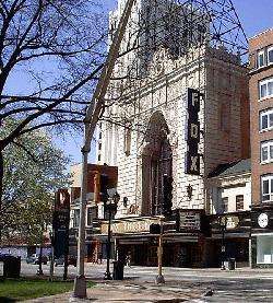
| Fox Theatre |
523 N. Grand
38°38′19″N 90°13′54″W / 38.6386°N 90.2317°W / 38.6386; -90.2317 (Fox Theatre) |
1929 |
|
000000001976-10-08-0000October 8, 1976 |
|
 |
| Goldenrod (showboat) |
Relocated to Calhoun County, Illinois
39°20′28″N 90°37′10″W / 39.3410°N 90.6194°W / 39.3410; -90.6194 (Goldenrod Showboat) |
1909 |
|
|
|
|
| Grand Avenue Water Tower |
20th and Grand
38°40′13″N 90°12′31″W / 38.6702°N 90.2086°W / 38.6702; -90.2086 (Grand Avenue Water Tower) |
1871 |
|
000000001970-06-15-0000June 15, 1970 |
|
 |
| Harris Row |
18th St. between LaSalle & Hickory
38°37′09″N 90°12′37″W / 38.6193°N 90.2103°W / 38.6193; -90.2103 (Harris Row) |
c. 1874 |
|
|
|
|
| Holy Corners Historic District |
Kingshighway Blvd between Westminster Pl and Washington Ave
38°39′01″N 90°15′49″W / 38.6504°N 90.2637°W / 38.6504; -90.2637 (Holy Corners Historic District) |
1902–1908 |
|
December 29, 1975 |
|
|
| Holy Cross Lutheran Church |
2650 Miami Street
38°35′23″N 90°13′41″W / 38.5898°N 90.2280°W / 38.5898; -90.2280 (Holy Cross Lutheran Church) |
1867 |
|
|
|
|
| Intake Water Tower No. 1 |
Mississippi River Channel
38°45′31″N 90°10′36″W / 38.7586°N 90.1768°W / 38.7586; -90.1768 (Intake Water Tower No. 1) |
1894 |
|
|
|
 |
| Intake Water Tower No. 2 |
Mississippi River Channel
38°45′33″N 90°10′28″W / 38.7593°N 90.1744°W / 38.7593; -90.1744 (Intake Water Tower No. 2) |
1913 |
|
|
|
 |
| Jefferson Memorial part of the Missouri History Museum |
Lindell & DeBaliviere
38°38′44″N 90°17′09″W / 38.6455°N 90.2857°W / 38.6455; -90.2857 (Jefferson Memorial) |
1911 |
|
|
|
 |
| Kingsbury Place |
Kingsbury Pl and Kinshighway Blvd
38°39′03″N 90°16′42″W / 38.6507°N 90.2782°W / 38.6507; -90.2782 (Kingsbury Place) |
c. 1890–1910 |
|
|
|
|
| Kulage House |
1904 E. College
38°40′34″N 90°12′46″W / 38.6762°N 90.2128°W / 38.6762; -90.2128 (Kulage House) |
1876 |
|
000000002002-05-10-0000May 10, 2002 |
|
|
| Lammert Furniture Building |
911 Washington Ave
38°37′52″N 90°11′36″W / 38.6311°N 90.1933°W / 38.6311; -90.1933 (Lammert Furniture Building) |
1897 |
|
|
|
|
| Lionberger House |
3630 Grandel
38°38′26″N 90°13′55″W / 38.6405°N 90.2320°W / 38.6405; -90.2320 (Lionberger House) |
1886 |
|
|
|
 |
| Lyle Mansion |
Carondelet Park
38°33′36″N 90°15′45″W / 38.5601°N 90.2624°W / 38.5601; -90.2624 (Lyle Mansion) |
1842 |
|
|
|
|
| Masonic Temple |
3681 Lindell Blvd
38°38′17″N 90°14′07″W / 38.6380°N 90.2354°W / 38.6380; -90.2354 (Masonic Hall) |
1926 |
|
|
|
 |
| May Company Department Store Building |
555 Washington Ave
38°37′49″N 90°11′20″W / 38.6302°N 90.1890°W / 38.6302; -90.1890 (May Company Department Store Building) |
1875 |
|
000000001983-06-23-0000June 23, 1983 |
|
|
| Meeting of the Waters Fountain |
Aloe Plaza
38°37′48″N 90°12′28″W / 38.6299°N 90.2077°W / 38.6299; -90.2077 (Meeting of the Waters Fountain) |
1940 |
|
|
|
|
| Memorial Home |
S. Grand & Magnolia Avenues
38°36′28″N 90°14′31″W / 38.6079°N 90.2419°W / 38.6079; -90.2419 (Memorial Home) |
1867 |
|
|
|
|
| Merchandise Mart Building |
1000 Washington Ave
38°37′51″N 90°11′40″W / 38.6309°N 90.1944°W / 38.6309; -90.1944 (Merchandise Mart Building) |
1889 |
|
|
|
|
| Merchants Laclede Building |
408 Olive Street
38°37′38″N 90°11′18″W / 38.6273°N 90.1883°W / 38.6273; -90.1883 (Merchants Laclede Building) |
1889 |
|
|
|
|
| Mississippi Valley Trust Company Building |
401 Pine Street
38°37′36″N 90°11′18″W / 38.6268°N 90.1883°W / 38.6268; -90.1883 (Mississippi Valley Trust Building) |
1896 |
|
May 25, 2001 |
|
 |
| Missouri Athletic Club Building |
409 Washington Ave
38°37′48″N 90°11′14″W / 38.6299°N 90.1873°W / 38.6299; -90.1873 (Missouri Athletic Club Building) |
1915 |
|
|
|
 |
| Most Holy Trinity Church |
3519 N. 14th Street
38°39′37″N 90°11′54″W / 38.6603°N 90.1984°W / 38.6603; -90.1984 (Most Holy Trinity Church) |
1899 |
|
|
|
|
| Old Mutual Bank Building |
716 Locust
38°37′45″N 90°11′30″W / 38.6291°N 90.1917°W / 38.6291; -90.1917 (Old Mutual Bank Building) |
1917 |
|
|
|
|
| Naked Truth Statue |
Compton Hill Reservoir Park
38°36′53″N 90°14′20″W / 38.6146°N 90.2390°W / 38.6146; -90.2390 (Naked Truth Statue) |
1914 |
|
|
|
 |
| Neighborhood Gardens Apartments |
1200 N. 8th
38°38′12″N 90°11′21″W / 38.6368°N 90.1893°W / 38.6368; -90.1893 (Neighborhood Gardens Apartments) |
1935 |
|
|
|
|
New Jerusalem Church of God
(formerly Most Holy Name of Jesus Catholic Church) |
2047 E. Grand Blvd
38°40′12″N 90°12′36″W / 38.6699°N 90.2099°W / 38.6699; -90.2099 (New Jerusalem Church of God) |
1916 |
|
|
|
|
| Old Courthouse |
11 N. 4th Street
38°37′32″N 90°11′20″W / 38.6256°N 90.1888°W / 38.6256; -90.1888 (Old Courthouse) |
1859 |
|
|
|
 |
Orpheum Theater
(formerly American Theater) |
416 N. 9th
38°37′48″N 90°11′34″W / 38.6301°N 90.1929°W / 38.6301; -90.1929 (Orpheum Theatre) |
1917 |
|
000000001985-03-18-0000March 18, 1985 |
|
 |
| Page Boulevard Police Station |
Page and Union Blvds |
1908 |
1995 |
|
|
|
| Pelican's Restaurant |
2256 S. Grand Ave
38°36′36″N 90°14′26″W / 38.6100°N 90.2406°W / 38.6100; -90.2406 (Pelican's Restaurant) |
1895 |
|
|
|
|
| Christian Peper Building |
721–27 N. 1st Street
38°37′49″N 90°11′00″W / 38.6304°N 90.1832°W / 38.6304; -90.1832 (Christian Peper Building) |
1874 |
|
|
|
|
| Homer G. Phillips Hospital |
2601 Whittier Ave
38°39′31″N 90°14′09″W / 38.6587°N 90.2358°W / 38.6587; -90.2358 (Homer G. Phillips Hospital) |
1937 |
|
September 23, 1982 |
|
 |
| Pilgrim Congregational Church (St. Louis, Missouri) |
826 Union Blvd
38°39′17″N 90°16′22″W / 38.6546°N 90.2729°W / 38.6546; -90.2729 (Pilgrim Congregational Church) |
1906 |
|
|
|
|
Powell Symphony Hall
(formerly St. Louis Theater) |
718 N. Grand Blvd
38°38′25″N 90°13′49″W / 38.6404°N 90.2302°W / 38.6404; -90.2302 (Powell Symphony Hall) |
1925 |
|
000000002001-05-25-0000May 25, 2001 |
|
 |
| Prince Hall Grand Lodge No. 2 |
3615-19 Dr. Martin Luther King Blvd |
1886 |
1995 |
|
|
|
| Resurrection of Our Lord Catholic Church |
3900 Meramec St
38°35′03″N 90°15′06″W / 38.5843°N 90.2517°W / 38.5843; -90.2517 (Resurrection of Our Lord Catholic Church) |
1954 |
|
|
|
|
| Sacred Heart of Jesus Catholic Church |
2830 N. 25th Street |
1898 |
1986 |
|
|
|
| Saint Louis Art Museum |
1 Fine Arts Drive (Forest Park)
38°38′22″N 90°17′39″W / 38.6395°N 90.2943°W / 38.6395; -90.2943 (Saint Louis Art Museum) |
1904 |
|
|
|
 |
Saint Louis University Museum of Art
(formerly the Woolworth Building) |
3663 Lindell Blvd
38°38′16″N 90°14′05″W / 38.6379°N 90.2348°W / 38.6379; -90.2348 (Saint Louis University Museum of Art) |
1899 |
|
|
|
 |
| Schlichtig House |
300 E. Marceau St
38°32′25″N 90°15′45″W / 38.5404°N 90.2624°W / 38.5404; -90.2624 (Schlichtig House) |
1852 |
|
May 29, 1980 |
|
|
| Second Presbyterian Church |
4501 Westminster
38°38′51″N 90°15′21″W / 38.6475°N 90.2557°W / 38.6475; -90.2557 (Second Presbyterian Church) |
1896 |
|
|
|
|
| Security Building |
319 N. 4th Street
38°37′41″N 90°11′16″W / 38.6280°N 90.1878°W / 38.6280; -90.1878 (Security Building) |
1890 |
|
|
|
|
| St. Alphonsus Catholic Church |
1118 N. Grand Blvd
38°38′39″N 90°13′41″W / 38.6442°N 90.2281°W / 38.6442; -90.2281 (St. Alphonsus Catholic Church) |
1893 |
|
|
|
|
| St. Francis DeSales Church |
2653 Ohio Ave
38°36′14″N 90°13′33″W / 38.6040°N 90.2257°W / 38.6040; -90.2257 (St. Francis de Sales Church) |
1906 |
|
|
|
 |
| St. Francis Xavier College Church |
Lindell and N Grand Blvds
38°38′13″N 90°13′59″W / 38.6370°N 90.2330°W / 38.6370; -90.2330 (St. Francis Xavier College Church) |
1898 |
|
|
|
 |
| St. John Nepomuk Church |
S. 11th St & Lafayette Ave
38°36′44″N 90°12′19″W / 38.6123°N 90.2053°W / 38.6123; -90.2053 (St. John Nepomuk Church) |
1895 |
|
|
|
 |
| St. John the Apostle and Evangelist Church |
abt 1600 Chestnut St
38°37′46″N 90°12′13″W / 38.6295°N 90.2035°W / 38.6295; -90.2035 (St. John the Apostle and Evangelist Church) |
1869 |
|
|
|
|
| Shrine of St. Joseph Catholic Church |
1220 N. 11th St
38°38′13″N 90°11′34″W / 38.6370°N 90.1927°W / 38.6370; -90.1927 (Shrine of St. Joseph Catholic Church) |
1844 |
|
000000001978-05-19-0000May 19, 1978 |
|
 |
| Sisters of St. Joseph Convent |
6400 Minnesota Ave
38°33′23″N 90°15′02″W / 38.5565°N 90.2506°W / 38.5565; -90.2506 (Sisters of St. Joseph Convent) |
1841 |
|
|
|
 |
| St. Liborius Church and Buildings |
1835 N. Market St
38°38′48″N 90°12′00″W / 38.6468°N 90.2001°W / 38.6468; -90.2001 (St. Liborius Church and Buildings) |
1857 |
|
000000001979-10-11-0000October 11, 1979 |
|
 |
| St. Louis Union Station |
1820 Market St
38°37′45″N 90°12′26″W / 38.6293°N 90.2073°W / 38.6293; -90.2073 (St. Louis Union Station) |
1894 |
|
000000001970-12-30-0000December 30, 1970 |
000000001970-12-30-0000December 30, 1970 |
 |
| St. Mark's Episcopal Church |
4712 Clifton Ave
38°35′15″N 90°17′43″W / 38.5875°N 90.2953°W / 38.5875; -90.2953 (St. Mark's Episcopal Church) |
1939 |
|
|
|
|
| St. Mary of Victories Catholic Church |
744 S. 3rd Street
38°37′05″N 90°11′26″W / 38.6180°N 90.1906°W / 38.6180; -90.1906 (St. Mary of Victories Catholic Church) |
1843 |
|
|
|
|
| Sts. Peter and Paul Church |
1919 S. 7th Street
38°36′25″N 90°12′13″W / 38.607°N 90.2036°W / 38.607; -90.2036 (Sts. Peter and Paul Church) |
c. 1873 |
|
|
|
|
| St. Stanislaus Kostka Church |
1419 N. 20th Street
38°38′31″N 90°12′21″W / 38.6420°N 90.2058°W / 38.6420; -90.2058 (St. Stanislaus Kostka Church) |
1891 |
|
000000001979-07-10-0000July 10, 1979 |
|
 |
| St. Vincent de Paul Church |
1417 S. 9th Street
38°36′48″N 90°12′02″W / 38.6133°N 90.2006°W / 38.6133; -90.2006 (St. Vincent DePaul Church) |
1844 |
|
|
|
|
| Henry Shaw's Country House |
Missouri Botanical Garden
38°36′42″N 90°15′30″W / 38.6116°N 90.2584°W / 38.6116; -90.2584 (Henry Shaw's Country House) |
1849 |
|
|
|
|
| Henry Shaw's Town House |
2315 Tower Grove Ave
(Missouri Botanical Garden)
38°36′39″N 90°15′28″W / 38.6107°N 90.2579°W / 38.6107; -90.2579 (Henry Shaw's Town House) |
1850 |
|
|
|
|
| Shaw Place |
Ten Houses
38°36′58″N 90°14′31″W / 38.6160°N 90.2419°W / 38.6160; -90.2419 (Shaw Place) |
1879 |
|
|
|
|
| Sheldon Concert Hall |
3646 Washington Ave
38°38′24″N 90°13′59″W / 38.6399°N 90.2331°W / 38.6399; -90.2331 (Sheldon Concert Hall) |
1912 |
|
|
|
 |
Shining Light Tabernacle
(formerly Christ Church) |
7121 Manchester Rd
38°36′58″N 90°18′40″W / 38.6160°N 90.3110°W / 38.6160; -90.3110 (Shining Light Tabernacle (formerly Christ Church)) |
1891 |
|
|
|
|
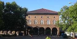
| Soulard Market |
730 Carroll St
38°36′39″N 90°12′03″W / 38.6109°N 90.2008°W / 38.6109; -90.2008 (Soulard Market) |
1928 |
|
|
|
 |
| Houses at 200-204 Steins and 7012 Minnesota |
200–204 W Steins St and 7012 Minnesota Ave
38°32′54″N 90°15′33″W / 38.5482°N 90.2591°W / 38.5482; -90.2591 (Houses at 200-204 Steins)
38°33′09″N 90°15′18″W / 38.5525°N 90.2550°W / 38.5525; -90.2550 (House at 7012 Minnesota) |
c. 1840–50 |
|
|
|
|
| South Broadway Bluff Area |
abt. 4500–5500 S. Broadway
38°34′01″N 90°14′18″W / 38.5669°N 90.2384°W / 38.5669; -90.2384 (South Broadway Bluff Area) |
|
|
|
|
|
| Jacob Steins House |
Steins & Reilly Streets
38°32′43″N 90°15′18″W / 38.5454°N 90.2550°W / 38.5454; -90.2550 (Jacob Steins House) |
1843 |
|
|
|
|
| Stockstrom House |
3400 Russell Blvd
38°36′46″N 90°14′10″W / 38.6127°N 90.2362°W / 38.6127; -90.2362 (Stockstrom House) |
1907 |
|
|
|
|
| Strassberger's Conservatory |
2300 S. Grand Ave
38°36′35″N 90°14′27″W / 38.6097°N 90.2407°W / 38.6097; -90.2407 (Strassberger's Conservatory) |
1904 |
|
|
|
|
| Towne Theatre |
210 N. 6th Street |
1896 |
1983 |
|
|
|
| Union Avenue Christian Church |
733 Union Ave
38°39′14″N 90°16′25″W / 38.6540°N 90.2737°W / 38.6540; -90.2737 (Union Avenue Christian Church) |
1904 |
|
|
|
|
| Union Market |
711 North Broadway
38°37′51″N 90°11′16″W / 38.6308°N 90.1879°W / 38.6308; -90.1879 (Union Market) |
1924 |
|
|
|
_(18742949543).jpg) |
| Union Trust Building |
705 Olive Street
38°37′42″N 90°11′30″W / 38.6284°N 90.1916°W / 38.6284; -90.1916 (Union Trust Building) |
1892 |
|
|
|
 |
| Unitarian Church of the Messiah |
508 N. Garrison Ave |
1879 |
1987 |
|
|
|
| United Missouri Bank Building |
312 N. 8th Street
38°37′44″N 90°11′31″W / 38.6290°N 90.1920°W / 38.6290; -90.1920 (United Missouri Bank Building) |
1892 |
|
|
|
|
| U.S. Customhouse and Post Office |
815 Olive St
38°37′45″N 90°11′34″W / 38.629104°N 90.192797°W / 38.629104; -90.192797 (U.S. Customhouse and Post Office) |
1884 |
|
000000001968-11-22-0000November 22, 1968 |
000000001970-12-30-0000December 30, 1970 |
 |
| Vess Advertising Device |
6th & O'Fallon Streets
38°38′12″N 90°11′12″W / 38.6368°N 90.1868°W / 38.6368; -90.1868 (Vess Advertising Device) |
1950 |
|
|
|
|
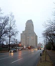
| Veterans Administration Building |
200 N. Broadway |
1907 |
1977 |
|
|
|
| Von Harten Residence |
5433 Enright Ave
38°39′17″N 90°16′38″W / 38.6548°N 90.2771°W / 38.6548; -90.2771 (Von Harten Residence) |
1896 |
|
|
|
|
| Wainwright Building |
705 Chestnut St
38°37′38″N 90°11′32″W / 38.6271°N 90.1921°W / 38.6271; -90.1921 (Wainwright Building) |
1892 |
|
000000001968-05-23-0000May 23, 1968 |
000000001968-05-23-0000May 23, 1968 |
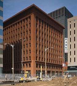 |
| Wainwright Tomb |
Bellefontaine Cemetery |
1892 |
|
000000001970-06-15-0000June 15, 1970 |
|
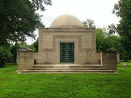 |
| Walz House |
4708 S. Broadway |
1849 |
1982 |
|
|
|
| Washington Tabernacle Baptist Church |
3200 Washington Ave
38°38′14″N 90°13′31″W / 38.6372°N 90.2254°W / 38.6372; -90.2254 (Washington Tabernacle Baptist Church) |
1879 |
|
|
|
|
| Washington Terrace |
48 Houses
38°39′06″N 90°16′25″W / 38.6516°N 90.2737°W / 38.6516; -90.2737 (Washington Terrace) |
c. 1890–1910 |
|
|
|
 |
| Westminster Presbyterian Church |
5300 Delmar Blvd
38°39′09″N 90°16′26″W / 38.6524°N 90.2739°W / 38.6524; -90.2739 (Westminster Presbyterian Church) |
1925 |
|
|
|
|
|