Lancefield railway line
| Lancefield | |
|---|---|
| Overview | |
| Type | V/Line passenger service |
| Status | Now operating as the Old Railway Station B & B and Carriage Cafe. |
| Former connections | Joined Bendigo mainline at Clarkefield, and Heathcote line (now closed) at Kilmore. |
| Stations | 12? |
| Operation | |
| Opened |
6 June 1881 to Lancefield, extended to Kilmore 6 April 1892. |
| Completed | 1892 to Kilmore. |
| Closed |
1 June 1897 beyond Lancefield, remainder closed 13 August 1956 |
| Number of tracks | Single |
| Lancefield railway line (Clarkefield - Kilmore, via Lancefield) | |||||||||||||||||||||||||||||||||||||||||||||||||||||||||||||||||||||||||||||||||||||||||||||||||||||||||||||||||||||||||||||||||
|---|---|---|---|---|---|---|---|---|---|---|---|---|---|---|---|---|---|---|---|---|---|---|---|---|---|---|---|---|---|---|---|---|---|---|---|---|---|---|---|---|---|---|---|---|---|---|---|---|---|---|---|---|---|---|---|---|---|---|---|---|---|---|---|---|---|---|---|---|---|---|---|---|---|---|---|---|---|---|---|---|---|---|---|---|---|---|---|---|---|---|---|---|---|---|---|---|---|---|---|---|---|---|---|---|---|---|---|---|---|---|---|---|---|---|---|---|---|---|---|---|---|---|---|---|---|---|---|---|---|
Legend
| |||||||||||||||||||||||||||||||||||||||||||||||||||||||||||||||||||||||||||||||||||||||||||||||||||||||||||||||||||||||||||||||||

The Lancefield railway line, or the Clarkefield and Lancefield Railway, was a former broad gauge railway in central Victoria, now operating as the Old Railway Station B & B and Carriage Cafe, connecting Clarkefield on the Bendigo line to Kilmore on the Heathcote line, via Lancefield. However, the ill-fated Lancefield-Kilmore section operated only briefly in the 1890s, so for much of its history the line existed simply as a spur line terminating at Lancefield station.
History
Clarkefield-Lancefield section
A railway branch line off the Melbourne-Bendigo line originated at Clarkefield (known then as Lancefield Junction) and ran to Bolinda, Monegeetta, North Monegeetta, Romsey and Lancefield,[1] opening on 6 June 1881.[2]
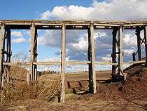
The Lancefield-Clarkefield section of the line was finally closed on 13 August 1956,[2] when the wooden trestle bridge near Clarkefield required extensive maintenance and repairs. Though the railway right of way no longer exists, the former track bed can still be seen in many places, most notably the embankments and cuttings leading onto the decaying trestle bridge, which are visible from the road-side at the Bolinda bridge. The old Lancefield railway station fell into a state of disrepair after its closure but has since been refurbished as the Old Railway Station B & B and Carriage Cafe. None of the other stations remain intact.
Lancefield-Kilmore section
On 6 April 1892, the line was extended from Lancefield across the Great Dividing Range to Kilmore.[3] This was one of the most infamous white elephants among the many late-nineteenth century Victorian rail projects, on a par with the Outer Circle railway line in suburban Melbourne.
Due to the steepness of the topography, not only was the Lancefield-Kilmore railway expensive to construct and meandering, it also ran through almost uninhabited land, with little or no passenger custom or freight use. The line was so unsuccessful that it was closed on 1 June 1897,[4] although the tracks were not torn up until 1917. Some of the old right of way is visible around the Lancefield Gap and on the approach into Kilmore.
For such a relatively short section of railway, the line had a significant number of stations, or at least named stopping-points. From Lancefield to Kilmore, stopping points included Mount William, Goldie, Springfield, High Park and Forbes[5][6]
References
- ↑ Railway Map of Victoria, Australia, 1946 map reproduced courtesy V/Line, Railway Museum, North Williamstown, Victoria, 1988
- 1 2 Mitchell, Peter; Alan Jackson; Carol Moore; Gavin Smith (2004). Romsey: A Veritable Garden of Eden. Romsey: West Bourke Books Inc. ISBN 0-646-43570-1.
- ↑ Turton, Keith (April 1970). "The Heathcote Junction to Bendigo and Associated Railways". Australian Railway Historical Society Bulletin: 69–88.
- ↑ Poole, L.G. (February 1953). "Some Notes on the Lancefield-Kilmore Section". Australian Railway Historical Society Bulletin: 22–23.
- ↑ Victorian Municipal Directory. Brunswick: Arnall & Jackson. 1956. pp. 751–2.
- ↑ "Railway Map of Victoria, 1900" (PDF). Victorian Railway Maps 1860 - 2000. Victorian Railways Resources. Retrieved 2010-06-20.