Lakes of Ounianga
| Lakes of Ounianga | |
|---|---|
| Name as inscribed on the World Heritage List | |
| Type | Nature |
| Criteria | vii |
| Reference | 1400 |
| UNESCO region | Africa |
| Inscription history | |
| Inscription | 2012 (36th Session) |

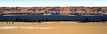
Lakes of Ounianga are a series of lakes in the Sahara Desert, in North-Eastern Chad, occupying a basin in the mountains of West Tibesti and Ennedi East. It was added as a UNESCO World Heritage site in 2012.[2]
According to the UNESCO description, the lakes are in a hot and hyperarid desert that features a rainfall of less than 2 millimetres (0.1 in) a year. The lakes exhibit a variety of sizes, depths, chemical compositions and colorations.
There is a total of 18 lakes in groups as follows:
- Ounianga Kébir group: Lake Yoa, Lake Katam, Lake Oma (or Ouma), Lake Béver, Lake Midji, Lake Forodom;
- Lake Motro, about 30 kilometres (19 mi) southeast of Ounianga Kébir;
- Ounianga Sérir group about 45 to 60 kilometres (28 to 37 mi) southeast of Ounianga Kébir: Lake Melekui, Lake Dirke, Lake Ardjou, Lake Téli, Lake Obrom, Lake Élimé, Lake Hogo, Lake Djiara, Lake Ahoita, Lake Daléyala, and Lake Boukkou.
The total surface area of the lakes is about 20 square kilometres (8 sq mi). The largest of the lakes, Lake Yoa, has about a 3.5-square-kilometre (1 sq mi) area and attains 20 metres (66 ft) in depth.
The names of the lake groups are derived from the name of a village nearby (literally, Ounianga Kébir = "the great Ounianga" and Ounianga Serir = "little Ounianga").
Geography
These lakes form a hydrological system that is unique in Earth’s deserts. Ordinarily when water is exposed at the surface in highly arid environments it becomes saline due to a high rate of evaporation. In this case, even though the rate of evaporation from Lake Yoa is equivalent to 6 metres (20 ft) a year, the total lake depth is 25 metres (82 ft), unique physical factors combine to keep all of the lakes, except the central Lake Teli, fresh. First, water accumulated in an underground aquifer during the wet millennia is supplied to the lakes. Second, wind blown sand separates the basin into 10 lakes with Lake Teli occupying a lower position than the lakes around it. Third, thick mats of reeds cover the surface of the fresh water lakes where they slow evaporation, but are absent from the saline waters of Lake Teli. As a result, greater evaporation takes place from the surface of Lake Teli, keeping its water level low. This allows water from the adjacent lakes to flow through the permeable dune barriers into Lake Teli keeping their waters fresh.[3]
Connection to the history of humanity
The climatic history of the region is speculated to have a connection to human migrations at the end of the last ice age about 11,000 years ago. The desert returned to the area after monsoons diminished about 5,000 years ago. Investigation of a drilling core revealed 10,940 layers in 16 metres (52 ft) of sediments from the bottom of the Lake Yoa before reaching the ice-age desert floor, each layer corresponding to 1 year.[4]
References
- ↑ NASA Earth Observatory, http://earthobservatory.nasa.gov/IOTD/view.php?id=41425.
- ↑ "Lakes of Ounianga". UNESCO. Retrieved 3 September 2012.
- ↑ Kröpelin, Stefan. "The Saharan lakes of Ounianga Serir (NE Chad): a unique hydrogeological system". Retrieved 2009-08-28.
- ↑ Johann Grolle, "Miracle in the Sahara: Oasis Sediments Archive Dramatic History", Spiegel-online, May 21, 2013, http://www.spiegel.de/international/world/new-sahara-research-the-lakes-of-ounianga-a-900518.html
| Wikimedia Commons has media related to Lakes of Ounianga. |
Coordinates: 19°03′N 20°29′E / 19.050°N 20.483°E