Lake Turkana
| Lake Turkana Jade Sea | |
|---|---|
 | |
 | |
| Coordinates | 3°35′N 36°7′E / 3.583°N 36.117°ECoordinates: 3°35′N 36°7′E / 3.583°N 36.117°E |
| Lake type | Saline, monomictic, alkaline, endorheic |
| Primary inflows | Omo River, Turkwel River, Kerio River |
| Primary outflows | Evaporation |
| Catchment area | 130,860 km2 (50,530 sq mi) |
| Basin countries | Kenya, Ethiopia |
| Max. length | 290 km |
| Max. width | 32 km (20 mi) |
| Surface area | 6,405 km2 (2,473 sq mi) |
| Average depth | 30.2 m (99 ft) |
| Max. depth | 109 m (358 ft) |
| Water volume | 203.6 km3 (165,100,000 acre·ft) |
| Salinity | 2.44% [1] |
| Surface elevation | 360.4 m (1,182 ft) |
| Islands | North Island, Central Island, South Island (volcanic) |
| Settlements | El Molo, Loyangalani, Kalokol, Eliye Springs, Ileret, Fort Banya. |
| Lake Turkana National Parks | |
|---|---|
| Name as inscribed on the World Heritage List | |
 | |
| Type | Natural |
| Criteria | viii, x |
| Reference | 801 |
| UNESCO region | Africa |
| Inscription history | |
| Inscription | 1997 (21st Session) |
| Extensions | 2001 |
Lake Turkana (/tɜːrˈkɑːnə/ or /tɜːrˈkænə/), formerly known as Lake Rudolf, is a lake in the Kenyan Rift Valley, in northern Kenya, with its far northern end crossing into Ethiopia.[2] It is the world's largest permanent desert lake and the world's largest alkaline lake. By volume it is the world's fourth-largest salt lake after the Caspian Sea, Issyk-Kul, and Lake Van (passing the shrinking South Aral Sea), and among all lakes it ranks 24th. The water is potable, but not palatable. It supports a rich lacustrine wildlife. The climate is hot and very dry.
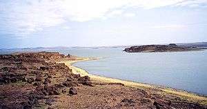
The rocks of the surrounding area are predominantly volcanic. Central Island is an active volcano, emitting vapour. Outcrops and rocky shores are found on the east and south shores of the lake, while dunes, spits and flats are on the west and north, at a lower elevation.
On-shore and off-shore winds can be extremely strong, as the lake warms and cools more slowly than the land. Sudden, violent storms are frequent. Three rivers (the Omo, Turkwel and Kerio) flow into the lake, but lacking outflow, its only water loss is by evaporation. Lake volume and dimensions are variable. For example, its level fell by 10 metres between 1975 and 1993.[3]
Due to temperature, aridity and geographic inaccessibility, the lake retains its wild character. Nile crocodiles are found in great abundance on the flats. The rocky shores are home to scorpions and carpet vipers.
Lake Turkana National Parks are now listed as a UNESCO World Heritage Site. Sibiloi National Park lies on the lake's eastern shore, while Central Island National Park and South Island National Park lie in the lake. Both are known for their Nile crocodiles.
In the Lake Turkana area an abundance of hominid fossils was discovered.
Name
The lake was named Lake Rudolf (in honour of Crown Prince Rudolf of Austria) by Count Sámuel Teleki de Szék and his second-in-command Lieutenant Ludwig Ritter Von Höhnel, a Hungarian and an Austrian, on 6 March 1888.[4] They were the first Europeans to have recorded visiting the lake after a long safari across East Africa. Natives who live around Lake Turkana include the Turkana, Rendille, Gabbra, Daasanach, Hamar Koke, Karo, Nyagatom, Mursi, Surma, and Molo peoples. For the location of many of these peoples, refer to the dialect map in the article.
J. W. Gregory reported in The Geographical Journal of 1894 that it was called "Basso Narok", meaning "Black Lake" in the Samburu language. Likewise, nearby Lake Chew Bahir is "Basso Naibor" in Samburu, meaning "White Lake". The Samburu are among the dominant tribes in the lake Turkana region when the explorers came."[5] What the native form of this phrase was, what it might mean, and in which language is not clear. The lake kept its European name during the colonial period of British East Africa. After the independence of Kenya, the president, Mzee Jomo Kenyatta, renamed it in 1975 after the Turkana, the predominant tribe there.
At some unknown time, the lake acquired an alternate name as the Jade Sea from its turquoise colour seen approaching from a distance. The colour comes from algae that rise to the surface in calm weather. This is likely also a European name. The Turkana refer to the lake as Anam Ka'alakol, meaning "the sea of many fish". It is from the name Ka'alakol that Kalokol, a town on the western shore of Lake Turkana, east of Lodwar, derives its name. The previous indigenous Turkana name for Lake Turkana was Anam a Cheper. The area still sees few visitors, being a two-day drive from Nairobi. The lake is also an imaginary boundary of the Rendille and Borana and Oromo to the Turkana land. The area is primarily clay-based and is more alkaline than seawater.
Biology

Biomes
The major biomes are the lake itself, which is an aquatic biome, and the surrounding region, which is classified as desert and xeric shrubland. The Chalbi Desert is east of the lake. During moister times, a dry grassland appears, featuring Aristida adcensionis and A. mutabilis. During drier times, the grass disappears. The shrublands contain dwarf shrubs, such as Duosperma eremophilum and Indigofera spinosa. Near the lake are doum palms.
Plankton
Both phytoplankton and zooplankton are found in the lake.[6] Of the former, cyanobacteria are represented by Microcystis aeruginosa and microalgae by Botryococcus braunii. Also present are Anabaenopsis arnoldii, Planctonema lauterbornii, Oocystis gigas, Sphaerocystis schroeteri, and some others. The zooplankton includes copepods, cladocerans and protozoans.
Fish
Compared to other large African lakes, Turkana has relatively few fish species in total; the lake holds about 50 fish species, including 11 endemics, such as the cichlids Haplochromis macconneli, H. rudolfianus and H. turkanae, the barb Barbus turkanae, the robber tetras Brycinus ferox and B. minutus, the Rudolf lates Lates longispinis, and the cyprinid Neobola stellae.[7] Non-endemics include species such as Nile tilapia, bichirs, the elephantfish Mormyrus kannume, African arowana, African knifefish, Distichodus niloticus, the Nile perch, and numerous others.[6][8] During the early Holocene, the water level of the lake was higher, and it overflowed into the Nile River, allowing fish and crocodiles access. Consequently, the non-endemic fishes in the lake are mainly riverine species of Nilotic origin.[7] Some of the non-endemics do not breed in the lake, but migrate up the Omo River and other affluents to breed.[7] The lake is heavily fished.
Birds
The Lake Turkana region is home to hundreds of species of birds native to Kenya.[9] The East African Rift System also serves as a flyway for migrating birds, bringing in hundreds more. The birds are essentially supported by plankton masses in the lake, which also feed the fish.
Some birds more common to Turkana are the little stint, the wood sandpiper, and the common sandpiper. The African skimmer (Rhyncops flavirostris) nests in the banks of Central Island. The white-breasted cormorant (Phalacrocorax lucidus) ranges over the lake, as do many other waterbirds. The greater flamingo wades in its shallows. Heuglin's bustard (Neotis heuglinii) is found in the east of the lake region.
Reptiles
The lake formerly contained Africa's largest population of Nile crocodiles: 14,000, as estimated in a 1968 study by Alistair Graham.[10]
The lake also has a large population of large water turtles, particularly in the area of Central Island.
Mammals
Over the dry grasslands ranges a frail population of grazing mammals and predators. The grazers are chiefly Grevy's zebra, Burchell's zebra, the beisa oryx, Grant's gazelle, the topi and the reticulated giraffe. They are hunted by the lion and the cheetah. Elephants and the black rhinoceroses are no longer seen, although Teleki reported seeing (and shooting) many. Closer to the dust is the cushioned gerbil (Gerbillus pulvinatus).
Geology
Lake Turkana is an East African Rift feature.[11] A rift is a weak place in the Earth's crust due to the separation of two tectonic plates, often accompanied by a graben, or trough, in which lake water can collect. The rift began when East Africa, impelled by currents in the mantle,[12] began separating from the rest of Africa, moving to the northeast. Currently, the graben is 320 km wide in the north of the lake, 170 km in the south. This rift is one of two, and is called the Great or Eastern Rift. There is another to the west, the Western Rift.
Lake Turkana is a unique feature of the East African landscape. Besides being a permanent desert sea, it is the only sea that retains the waters originating from two separate catchment areas of the Nile. The Lake Turkana drainage basin draws its waters mainly from Kenya Highlands and Ethiopian Highlands.
The basement rocks of the region have been dated by two analytical determinations to 522 and 510 million years ago (mya). No rift was in the offing at that time. A rift is signalled by volcanic activity through the weakened crust. The oldest volcanic activity of the region occurred in the Nabwal Hills northeast of Turkana and is dated to 34.8 mya in the late Eocene.[13]
The visible tectonic features of the region result from extensive extrusions of basalt over the Turkana-Omo basin in the window 4.18–3.99 mya.[14] These are called the Gombe Group Basalts. They are subdivided into the Mursi Basalts and the Gombi Basalts.
The two latter basalts are identified as the outcrops forming the rocky mountains and badlands around the lake. In the Omo portion of the basin, of the Mursi Basalts, the Mursi Formation is on the west side of the Omo, the Nkalabong on the Omo, and the Usno and Shungura east of the Omo. Probably the best known of the formations are the Koobi Fora on the east side of Turkana and the Nachukui on the west.
Short-term fluctuations in lake level combined with periodic volcanic ash spewings over the region have resulted in a fortuitous layering of the ground cover over the basal rocks. These horizons can be dated more precisely by chemical analysis of the tuff.[15] As this region is believed to have been an evolutionary nest of hominins, the dates are important for generating a diachronic array of fossils, both hominoid and nonhominoid—that is, both ape (includes hominins) and non-ape. Many thousands have been excavated.
Terraces representing ancient shores are visible in the Turkana Basin. The highest is 75 m above the surface of the lake (only approximate, as the lake level fluctuates), which was current about 9500 years ago, at the end of the Pleistocene. It is generally theorised that Turkana was part of the upper Nile system at that time, connecting to Lake Baringo at the southern end and the White Nile in the north, and that volcanic land adjustments severed the connection. Such a hypothesis explains the Nile species in the lake, such as the crocodiles and the Nile perch.
Anthropology
Hominin fossils of some of the earliest human ancestors have been found in the Turkana Basin. Australopithecus anamensis fossils discovered by Meave Leakey in 1994 date to around 4 million years ago. Richard Leakey has led numerous anthropological expeditions in the area which have led to many important discoveries of hominin remains.
The two-million-year-old skull 1470 was found in 1972. It was originally thought to be Homo habilis, but the scientific name Homo rudolfensis, derived from the old name of this lake (Rudolf) was proposed in 1986 by V. P. Alexeev. In 1984, the Turkana Boy, a nearly complete skeleton of a Homo ergaster juvenile, was discovered by Kamoya Kimeu. More recently, Meave Leakey discovered a 3.5 million-year-old skull there, designated Kenyanthropus platyops ("the flat-faced man of Kenya").
Marta Mirazón Lahr discovered the earliest evidence of human warfare at the site of Nataruk, located near the shore of an ancient and larger Lake Turkana, and where numerous human skeletons showing major traumatic injuries to the head, neck, ribs, knees and hands are evidence of inter-group conflict between nomadic hunter-gatherers 10,000 years ago.[16]
Wind power
The Lake Turkana Wind Power consortium (LTWP) plans to provide 300 MW of power to Kenya's national electricity grid by tapping the unique wind conditions around the lake.[17] The plan calls for 360 wind turbines, each with a nameplate capacity of 850 kilowatts. As of March 2010, the project had found financing, and the Kenyan government will take responsibility for the construction of the transmission lines. If completed, it will become the largest wind power project in Africa.[18]
See also
| Wikimedia Commons has media related to Lake Turkana. |
- Hadar, Ethiopia
- Laetoli
- Middle Awash
- Olduvai Gorge
- Omo Kibish Formation
- Rift Valley lakes
- Rivers of Kenya
- Tugen Hills
References
- ↑ HYDROLOGICAL IMPACTS OF ETHIOPIA’S OMO BASIN ON KENYA’S LAKE TURKANA WATER LEVELS & FISHERIES (2010), page 2-65 (Pdf)
- ↑ The boundary between Ethiopia and Kenya has been a contentious rational distinction. A brief consideration of the topic can be found in the State Department document, Ethiopia – Kenya Boundary
- ↑ Historic lake levels are graphed in the World Lakes Database.
- ↑ A summary of the European discovery as well as Teleki's map and some Turkana tribe legends are stated in a University of Trieste document online.
- ↑ "Contributions to the Physical Geography of British East Africa" Geographical Journal, 4 (1894), pp. 289–315.
- 1 2 The World Lakes Database includes mention of the lake plankton, some of which are responsible for its turquoise colour.
- 1 2 3 Freshwater Ecoregions of the World (2008). Lake Turkana. Accessed 2 May 2011
- ↑ Fish Species in Lake Turkana
- ↑ The Internet hosts a number of bird sites giving scientific names, data and photographs of birds found around the lake: The Sibiloi National Park site, the Kenya Birds site, the African Bird Image Database, the Birdlife International site, and many others.
- ↑ Alistair Graham, Eyelids of Morning
- ↑ A good introduction is stated in the Regions of Kenya site.
- ↑ For the mantle currents, or "plumes", see the abstract of Tertiary Mafic Lavas of Turkana ..., Journal of Petrology Volume 47, Number 6 Pp. 1221–1244.
- ↑ See the abstract of Geochronology of the Nabwal Hills ..., Geological Magazine; January 2006; v. 143; no. 1; p. 25-39.
- ↑ See Mineral chemistry of Turkana basalts and implications for basin development, Karla Knudson, Louise Miltich, Nick Swanson-Hysell. The article is highly technical. Look for the summaries.
- ↑ Refer to the abstract of Precise ... geochronology for the upper Koobi Fora Formation...., Journal of the Geological Society; January 2006; v. 163; no. 1; p. 205-220.
- ↑ Lahr, M. Mirazón; Rivera, F.; Power, R. K.; Mounier, A.; Copsey, B.; Crivellaro, F.; Edung, J. E.; Fernandez, J. M. Maillo; Kiarie, C. "Inter-group violence among early Holocene hunter-gatherers of West Turkana, Kenya". Nature. 529 (7586): 394–398. doi:10.1038/nature16477.
- ↑ Lake Turkana Wind Power
- ↑ Africa’s Largest Wind Project Advances, New York Times, 16 March 2010
Sources
- Encyclopædia Britannica under "Rudolf, Lake"
- Chambers World Gazeteer, ed. David Munro, W & R Chambers Ltd. & The Press Syndicate of the University of Cambridge, 5th Edition, 1988, ISBN 978-1-85296-200-5 under Turkana, Lake.
External links
- Lake Turkana's entry on UNESCO's list of World Heritage Sites
- Satellite images showing Lake Turkana's falling water levels
- Ongoing Palaeoanthropological research in the Turkana Basin
- World Lakes Database
- Lake Turkana National Park
- "Masai Xeric Grasslands and Shrublands". Terrestrial Ecoregions. World Wildlife Fund.
- Remote Tribes of Northern Kenya
- Crocodile Natural History
- Africa Resources Working Group Gibe III Dam Lake Turkana
- The Turkana Basin Institute
- Sibiloi National Park, World Heritage Site