Lake Noquebay
| Lake Noquebay | |
|---|---|
 Lake Noquebay | |
| Location | Marinette County, Wisconsin, United States |
| Coordinates | 45°15′19″N 87°54′39″W / 45.2553°N 87.9109°WCoordinates: 45°15′19″N 87°54′39″W / 45.2553°N 87.9109°W |
| Type | Drainage |
| Primary outflows | Peshtigo River |
| Basin countries | United States |
| Surface area | 2,410 acres (9.8 km2) |
| Max. depth | 51 feet (16 m) |
| Water volume | 23,985.54 acre feet (29,585,730 m3) |
| Shore length1 | 9.8 miles (15.8 km) |
| Surface elevation | 659 ft (201 m) |
| Settlements | Crivitz |
| 1 Shore length is not a well-defined measure. | |
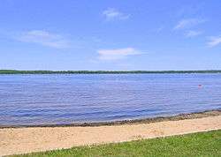
Lake Noquebay is a large freshwater lake in northeastern Wisconsin.
Statistics
It is approx. 2 miles (3.2 km) by 4 miles (6.4 km) and has a surface area of about 2,410 acres (9.8 km2). It has 3 small tributaries: Upper Inlet Creek, Middle Inlet Creek, and Lower Middle Inlet Creek. The Lake Noquebay Dam, constructed in 1929 at the southwest corner of the lake, maintains the water level at between 664.95 feet (202.68 m) and 666.2 feet (203.1 m). Fish species include bluegill, crappie, bass, walleye, northern pike, trout, rock bass, perch, and muskellunge. The lake is well noted for its "huge" bluegills.
Recreation
Lake Noquebay is popular year round with boating, fishing, snowmobiling, and waterskiing. Lake Noquebay County Park lies on the south shore of the lake and includes picnic areas with grills, a playground, restrooms, a boat launch, a sandy beach, and changing booths for swimmers. The Crivitz Ski Cats Waterski Club performs weekly in the summer.
Located north of Green Bay, Wisconsin, just a few minutes east of Crivitz, Wisconsin.[1]