Lake Minchin
Lake Minchin is a name of an ancient lake in the Altiplano of South America. It existed where today the Salar de Uyuni, Salar de Coipasa and Lake Poopó lie. It was formerly considered the highest lake in the Altiplano but research indicated that the highest shoreline belongs to the later Lake Tauca instead.
The concept of a "Lake Minchin" was first coined in 1906 and it is based on John B. Minchin. The dating of the lake varies but probably lasted until 22,000 – 21,000 BP. A glacier advance was in progress in the Andes during that timeperiod.
The name "Minchin" has also been used in other contexts, and it has been proposed that the lake was actually a combination of several different paleolakes.
Term
The name "Lake Minchin" has been used inconsistently to refer to either a lake existing 45,000 years ago, the highest lake in the Altiplano or sediment formations, leading to calls to drop the usage of the name "Minchin".[1] An alternative theory postulates that Lake Minchin was formed by several lakes , including Ouki and Inca Huasi.[2][3] Sometimes the term "Minchin" is also applied to the whole hydrological system Titicaca-Rio Desaguadero-Lake Poopo-Salar de Coipasa-Salar de Uyuni,[4] or to the highest ancient lake in the Altiplano (usually known as Lake Tauca).[5] There are also contradictions between lake level records in different parts of the system.[6]
Context
During its history a number of lakes appeared and then disappeared on the Altiplano. Lake Minchin was one of the first of these ancient lakes to be described. These lakes were identified by the lake terraces, sediments and bioherms.[7] Earlier lakes such as Lake Escara are documented from drill holes in the Salar de Uyuni.[8] Later lakes include Lake Tauca and Lake Coipasa.[9] As early as 1861 there are reports that lake deposits exist on the Altiplano.[10] John B. Minchin in 1882 reported the existence of encrustations around Lake Poopo and the salars south of Coipasa. He postulated a lake with a surface area of 120,000 square kilometres (46,000 sq mi) left these encrustations and that the nitrate deposits in the Atacama and Tarapaca were likewise formed by water draining for this lake. Some estimates of the size of this lake claimed that it reached from Lake Titicaca as far as 27° south. The name "Lake Minchin" was applied in 1906 by Steinmann, who applied it to the Uyuni basin, while naming the lake covering the Poopo and Coipasa basins "Lake Reck".[11] The name was applied in honour of John B. Minchin.[4] Later it was found that Lake Titicaca was not part of Lake Minchin and the theory was put forward that meltwater from glaciers had formed the lake. A different lake Lake Ballivian was also defined which encompassed Lake Titicaca.[12] The relationship between various deposits in the southern Altiplano and these around Lake Titicaca was unclear at the beginning of the research history.[13]
Lake
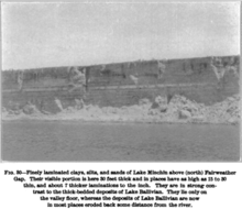
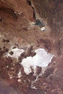
Lake Minchin was a saltwater lake,[14] which covered the basins of the Salar de Uyuni, Salar de Coipasa, Lake Poopo and Salar de Empexa.[15] [7] The lake had an extension of 200 kilometres (120 mi) in east-west direction and of 400 kilometres (250 mi) in north-south direction.[16] A sill at Ulloma separated Lake Minchin from Lake Titicaca.[17] Water levels reached an altitude of 3,730 metres (12,240 ft) above sea level,[8] indicating a depth of 100–140 metres (330–460 ft) above the Uyuni basin.[18][19] In the Poopo basin, water levels may have reached 45 metres (148 ft).[20] At Cerro Lipillipi terraces between 3,680–3,735 metres (12,073–12,254 ft) are dated between 25,700 and 31,750 BP.[21] Another estimate is 3,760–3,720 metres (12,340–12,200 ft).[22] Earlier estimates of the altitude are 3,660–3,705 metres (12,008–12,156 ft), resulting in depths of 40–90 metres (130–300 ft). Such water heights exceed these of preceding lakes, and together with even higher water levels of the subsequent Lake Tauca they are part of a trend of increasing water levels in the southern Altiplano which contrasts with progressively decreasing lake levels in the northern Altiplano.[18] Earlier research suggested an opposite trend of lowering water levels in both basins.[23] The surface area of Lake Minchin may have been 40,000–60,000 square kilometres (15,000–23,000 sq mi),[24] or 63,000 square kilometres (24,000 sq mi).[25] A lake terrace at 3,765 metres (12,352 ft) is also attributed to Lake Minchin.[26] The highest lake terraces at 3,772–3,784 metres (12,375–12,415 ft) and 3,760 metres (12,340 ft) were later found to belong to Lake Tauca, making it the deeper of the two lakes.[21][22] If Minchin reached a water level of 3,830 metres (12,570 ft) it may have spilled into the Pilcomayo River, draining from there via the Rio de la Plata into the Atlantic Ocean.[27] San Agustin, San Cristobal and Colcha formed islands in the lake, which was separated into a Coipasa half and an Uyuni half by a peninsula.[16]
Sediments left by the lake indicate the presence of gastropods, ostracods and stromatolites. At Estancia Vinto, several different species have been found, including the ostracods Amphicypris, Candonopsis, Darwinula, Limnocythere, Limnocythere bradburyi, Limnocythere titicaca and the molluscs Anysancylus crequii, Ecpomastrum mirum, Littoridina poopoensis, Taphius montanus. Some species variation may indicate that water levels at the site fluctuated;[26] for example the deepwater diatoms Cyclotella meneghiniana and Cyclotella stelligera but also benthic species.[28] Around the lake, Polylepis expanded and quantities of water supported Isoetes and Myriophyllum.[29] In comparison to Lake Tauca, the climate around Lake Minchin was more favourable to the development of vegetation, probably thanks to higher temperatures and a lower water level.[30] On the other hand, the lake may have acted like a barrier and prevented the movement of animals and plants between the south and north of the lake.[31]
Salt content has been estimated at 30–130 grams per litre (4.8–20.8 oz/imp gal).[25] It was dominated by NaCl, Na-Cl-CO3 and Na-Cl-SO4, as determined from studies on diatoms.[32] When the lake dried up, it left clay and sand deposits in the Altiplano.[33] Also, the volume of about 5,000 cubic kilometres (1,200 cu mi) maximum of water induced the ground beneath the lake to sink by about 30 metres (98 ft).[34]
Lake chronology
The early research in 1978 distinguished a Lake Minchin prior to 32,200 calibrated radiocarbon years and a later Lake Tauca. The exact history of Lake Minchin was little understood at that time,[7] with uranium-thorium dating yielding ages of 34,000 – 44,000 and 68,000 – 72,000 years BP.[35] These two phases were also called "Upper Minchin" and "Lower Minchin".[36] However, it was later found that radiocarbon dates on these samples indicated much lower ages,[22] from 28,000 years ago to dates too old for radiocarbon dating.[37] Between 31,000 and 26,000 the lake would have reached its highest level.[38] Around 27,500 BP, the lake reached its second highest level.[39] The drying of the lake did probably occur after about 22,000 BP.[22] Based on sedimentation rates in the Uyuni basin, it is likely that Lake Minchin was not continuous in existence during this timeperiod.[8] Other dates extend the time period of Lake Minchin until 21,000 years BP,[17] or set it earlier at 38,000 years BP.[9] Yet another proposal postulates that the earliest deep lake occurred 120,000 – 98,000 years ago.[40]
Origin
The formation of Lake Minchin was at first explained with glacial meltwater formed during an interglacial.[41] This idea was disputed because the growth of lakes happens at the same time as the growth of glaciers rather than afterwards.[42] An alternative explanation postulates an increase of precipitation over the Altiplano.[43] Higher insolation may have played a role in the expansion of Lake Minchin.[27] Water from Lake Titicaca may have contributed to the formation of Lake Minchin.[44]
Related events
The Choqueyapu II glacier advance was probably underway during the Lake Minchin phase and eventually led to the local Last Glacial Maximum,[45] and the Canabaya glacier advance in the Cordillera Real may also be linked to the Minchin phase.[46] Summer insolation was increased during the Lake Minchin period.[9] During the Lake Minchin period, precipitation on the Altiplano was higher than today.[20] This precipitation increase started 54,800 years ago, while the time period between Lake Minchin and Lake Tauca featured a dry climate.[47] ENSO variations also occurred during the Minchin period.[48]
Minchin is also the name of a highstand of Lake Titicaca at approximately 3,825 metres (12,549 ft) of altitude.[7] The highstand phase there ended about 20,000 BP.[49] During the time of Lake Minchin, water levels in Lake Titicaca rose by about 15 metres (49 ft).[26]
Water level rises are also recorded from lakes in the southern Lipez region during the time of Lake Minchin and in lesser measure during the time of Lake Tauca, where they may have formed from increased precipitation.[39] The Salar de Atacama likewise was wetter between 53,400 – 15,300 years ago.[9] Other phenomena associated with the Lake Minchin period are an increased landslide activity in northwest Argentina,[50] the formation of lakes behind such landslides,[48] an increase of sediment deposition along the Rio Pisco in Peru and its probable subsequent erosion.[51]
References
- ↑ Placzek, Quade & Patchett 2006, p. 517.
- ↑ Placzek, Quade & Patchett 2006, p. 528.
- ↑ McPhillips, Devin; Bierman, Paul R.; Crocker, Thomas; Rood, Dylan H. (December 2013). "Landscape response to Pleistocene-Holocene precipitation change in the Western Cordillera, Peru: Be concentrations in modern sediments and terrace fills". Journal of Geophysical Research: Earth Surface. 118 (4): 2490. doi:10.1002/2013JF002837.
- 1 2 Sánchez-Saldías & Fariña 2014, p. 250.
- ↑ Bills, Bruce G.; Borsa, Adrian A.; Comstock, Robert L. (March 2007). "MISR-based passive optical bathymetry from orbit with few-cm level of accuracy on the Salar de Uyuni, Bolivia". Remote Sensing of Environment. 107 (1–2): 243. doi:10.1016/j.rse.2006.11.006.
- ↑ Chepstow-Lusty et al. 2005, p. 91.
- 1 2 3 4 Fornari, Risacher & Féraud 2001, p. 270.
- 1 2 3 Fornari, Risacher & Féraud 2001, p. 279.
- 1 2 3 4 Bobst et al. 2001, p. 37.
- ↑ Moon 1939, p. 30.
- ↑ Moon 1939, p. 31.
- ↑ Moon 1939, p. 32.
- ↑ Bowman 1914, p. 178.
- ↑ Servant-Vildary 1993, p. 70.
- ↑ Ericksen, Vine & Raul Ballón 1978, p. 355.
- 1 2 Arellano 1984, p. 87.
- 1 2 Wirrmann & Mourguiart 1995, p. 348.
- 1 2 Fornari, Risacher & Féraud 2001, p. 280.
- ↑ Donselaar, M.E.; Cuevas Gozalo, M.C.; Moyano, S. (January 2013). "Avulsion processes at the terminus of low-gradient semi-arid fluvial systems: Lessons from the Río Colorado, Altiplano endorheic basin, Bolivia". Sedimentary Geology. 283: 2. doi:10.1016/j.sedgeo.2012.10.007.
- 1 2 ZOLÁ, RAMIRO PILLCO; BENGTSSON, LARS (February 2006). "Long-term and extreme water level variations of the shallow Lake Poopó, Bolivia". Hydrological Sciences Journal. 51 (1): 99. doi:10.1623/hysj.51.1.98.
- 1 2 Blodgett, Isacks & Lenters 1997, p. 2.
- 1 2 3 4 Clapperton et al. 1997, p. 57.
- ↑ Wirrmann & Mourguiart 1995, p. 346.
- ↑ Thompson, L. G. (4 December 1998). "A 25,000-Year Tropical Climate History from Bolivian Ice Cores". Science. 282 (5395): 1862. doi:10.1126/science.282.5395.1858.
- 1 2 Wirrmann, Denis; Mourguiart, Philippe; Almeida, Oliveira (1988). "Holocene sedimentology and ostracods distribution in Lake Titicaca : paleohydrological interpretations". Quaternary of South America and Antarctic Peninsula: 90. Retrieved 11 October 2016.
- 1 2 3 Wirrmann & Mourguiart 1995, p. 349.
- 1 2 Sánchez-Saldías & Fariña 2014, p. 258.
- ↑ Fritz, Sherilyn C; Baker, Paul A; Lowenstein, Tim K; Seltzer, Geoffrey O; Rigsby, Catherine A; Dwyer, Gary S; Tapia, Pedro M; Arnold, Kimberly K; Ku, Teh-Lung; Luo, Shangde (January 2004). "Hydrologic variation during the last 170,000 years in the southern hemisphere tropics of South America". Quaternary Research. 61 (1): 102. doi:10.1016/j.yqres.2003.08.007.
- ↑ Chepstow-Lusty et al. 2005, p. 95.
- ↑ Chepstow-Lusty et al. 2005, p. 97.
- ↑ Spotorno, Angel E.; Veloso, Alberto (1990-01-01). Schull, William J.; Rothhammer, Francisco, eds. The Aymara. Studies in Human Biology. Springer Netherlands. p. 27. doi:10.1007/978-94-009-2141-2_2. ISBN 9789401074636.
- ↑ Servant-Vildary 1993, p. 71.
- ↑ Lavenu, Alain (1995). "Geodinamica plio-quaternaria en los Andes Centrales: El Altiplano Norte de Bolivia" (PDF). ResearchGate (in Spanish). Revista Tecnica de YPFB. p. 83. Retrieved 15 October 2016.
- ↑ Bills, Bruce G.; Adams, Kenneth D.; Wesnousky, Steven G. (8 June 2007). "Viscosity structure of the crust and upper mantle in western Nevada from isostatic rebound patterns of the late Pleistocene Lake Lahontan high shoreline". Journal of Geophysical Research. 112 (B6): 2. doi:10.1029/2005JB003941.
- ↑ Fornari, Risacher & Féraud 2001, p. 271.
- ↑ ROUCHY, JEAN MARIE; SERVANT, MICHEL; FOURNIER, MARC; CAUSSE, CHRISTIANE (December 1996). "Extensive carbonate algal bioherms in upper Pleistocene saline lakes of the central Altiplano of Bolivia". Sedimentology. 43 (6): 975. doi:10.1111/j.1365-3091.1996.tb01514.x.
- ↑ Placzek, Quade & Patchett 2006, p. 516.
- ↑ Blodgett, Isacks & Lenters 1997, p. 20.
- 1 2 Clapperton et al. 1997, p. 52.
- ↑ Placzek, Quade & Patchett 2006, p. 531.
- ↑ Vita-Finzi, C. (September 1959). "A Pluvial Age in the Puna de Atacama". The Geographical Journal. 125 (3/4): 401. doi:10.2307/1791124.
- ↑ Fernández, Jorge; Markgraf, Vera; Panarello, Héctor O.; Albero, Miguel; Angiolini, Fernando E.; Valencio, Susana; Arriaga, Mirta (July 1991). "Late pleistocene/early holocene environments and climates, fauna, and human occupation in the argentine altiplano". Geoarchaeology. 6 (3): 268–269. doi:10.1002/gea.3340060303.
- ↑ Wirrmann, Denis; De Oliveira Almeida, Luiz Fernando (January 1987). "Low Holocene level (7700 to 3650 years ago) of lake Titicaca (Bolivia)". Palaeogeography, Palaeoclimatology, Palaeoecology. 59: 322. doi:10.1016/0031-0182(87)90088-5.
- ↑ Fritz, S.C.; Baker, P.A.; Tapia, P.; Spanbauer, T.; Westover, K. (February 2012). "Evolution of the Lake Titicaca basin and its diatom flora over the last ~370,000years". Palaeogeography, Palaeoclimatology, Palaeoecology. 317–318: 101. doi:10.1016/j.palaeo.2011.12.013.
- ↑ Clapperton et al. 1997, p. 58.
- ↑ Seltzer, Geoffry O. (January 1990). "Recent glacial history and paleoclimate of the Peruvian-Bolivian Andes". Quaternary Science Reviews. 9 (2–3): 150. doi:10.1016/0277-3791(90)90015-3.
- ↑ Steffen, Schlunegger & Preusser 2009, p. 492.
- 1 2 Bookhagen, Bodo; Haselton, Kirk; Trauth, Martin H (May 2001). "Hydrological modelling of a Pleistocene landslide-dammed lake in the Santa Maria Basin, NW Argentina". Palaeogeography, Palaeoclimatology, Palaeoecology. 169 (1–2): 126. doi:10.1016/S0031-0182(01)00221-8.
- ↑ Servant-Vildary 1993, pp. 69–70.
- ↑ Trauth, Martin H.; Bookhagen, Bodo; Marwan, Norbert; Strecker, Manfred R. (May 2003). "Multiple landslide clusters record Quaternary climate changes in the northwestern Argentine Andes". Palaeogeography, Palaeoclimatology, Palaeoecology. 194 (1–3): 118. doi:10.1016/S0031-0182(03)00273-6.
- ↑ Steffen, Schlunegger & Preusser 2009, p. 493.
Sources
- Arellano, Jorge (1984-01-01). "Comunicación preliminar sobre asentamientos precerámicos en el sur de Bolivia". Estudios Atacameños. Arqueología y antropología surandinas (in Spanish). 0 (7): 85–92. ISSN 0718-1043.
- Blodgett, Troy A.; Isacks, Bryan L.; Lenters, John D. (January 1997). "Constraints on the Origin of Paleolake Expansions in the Central Andes". Earth Interactions. 1 (1). doi:10.1175/1087-3562(1997)001<0001:COTOOP>2.3.CO;2.
- Bobst, Andrew L; Lowenstein, Tim K; Jordan, Teresa E; Godfrey, Linda V; Ku, Teh-Lung; Luo, Shangde (September 2001). "A 106ka paleoclimate record from drill core of the Salar de Atacama, northern Chile". Palaeogeography, Palaeoclimatology, Palaeoecology. 173 (1–2): 21–42. doi:10.1016/S0031-0182(01)00308-X.
- Bowman, Isaiah (1914). "Results of an Expedition to the Central Andes". Bulletin of the American Geographical Society. 46 (3). doi:10.2307/201641.
- Chepstow-Lusty, Alex; Bush, Mark B.; Frogley, Michael R.; Baker, Paul A.; Fritz, Sherilyn C.; Aronson, James (January 2005). "Vegetation and climate change on the Bolivian Altiplano between 108,000 and 18,000 yr ago". Quaternary Research. 63 (1): 90–98. doi:10.1016/j.yqres.2004.09.008.
- Clapperton, C.M.; Clayton, J.D.; Benn, D.I.; Marden, C.J.; Argollo, J. (January 1997). "Late Quaternary glacier advances and palaeolake highstands in the Bolivian Altiplano". Quaternary International. 38–39: 49–59. doi:10.1016/S1040-6182(96)00020-1.
- Ericksen, George E.; Vine, James D.; Raul Ballón, A. (June 1978). "Chemical composition and distribution of lithium-rich brines in salar de Uyuni and nearby salars in southwestern Bolivia". Energy. 3 (3): 355–363. doi:10.1016/0360-5442(78)90032-4.
- Fornari, Michel; Risacher, François; Féraud, Gilbert (August 2001). "Dating of paleolakes in the central Altiplano of Bolivia". Palaeogeography, Palaeoclimatology, Palaeoecology. 172 (3–4): 269–282. doi:10.1016/S0031-0182(01)00301-7.
- Moon, H. P. (December 1939). "III. THE GEOLOGY AND PHYSIOGRAPHY OF THE ALTIPLANO OF PERU AND BOLIVIA". Transactions of the Linnean Society of London: 3rd Series. 1 (1): 27–43. doi:10.1111/j.1096-3642.1939.tb00003.x.
- Placzek, C.; Quade, J.; Patchett, P. J. (8 May 2006). "Geochronology and stratigraphy of late Pleistocene lake cycles on the southern Bolivian Altiplano: Implications for causes of tropical climate change". Geological Society of America Bulletin. 118 (5–6): 515–532. doi:10.1130/B25770.1.
- Sánchez-Saldías, Andrea; Fariña, Richard A. (March 2014). "Palaeogeographic reconstruction of Minchin palaeolake system, South America: The influence of astronomical forcing". Geoscience Frontiers. 5 (2): 249–259. doi:10.1016/j.gsf.2013.06.004.
- Servant-Vildary, S.; Mello e Sousa, S. H. (June 1993). "Palaeohydrology of the Quaternary saline Lake Ballivian (southern Bolivian Altiplano) based on diatom studies". International Journal of Salt Lake Research. 2 (1): 69–85. doi:10.1007/BF02905054.
- Steffen, D.; Schlunegger, F.; Preusser, F. (4 June 2009). "Drainage basin response to climate change in the Pisco valley, Peru". Geology. 37 (6): 491–494. doi:10.1130/G25475A.1.
- Wirrmann, Denis; Mourguiart, Philippe (May 1995). "Late Quaternary Spatio-temporal Limnological Variations in the Altiplano of Bolivia and Peru". Quaternary Research. 43 (3): 344–354. doi:10.1006/qres.1995.1040.
External links
- Hydro‐isostatic deflection and tectonic tilting in the central Andes: Initial results of a GPS survey of Lake Minchin shorelines
- Aguas, Glaciares y cambios climaticos en los Andes tropicales