Hula Valley
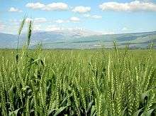

The Hula Valley (Hebrew: עמק החולה, translit. Emek Ha-Ḥula; also transliterated as Huleh Valley) is an agricultural region in northern Israel with abundant fresh water. It is a major stopover for birds migrating along the Syrian-African Rift Valley between Africa, Europe, and Asia. The marshland around Lake Hula, a breeding ground for mosquitoes carrying malaria, was drained in the 1950s. A small section of the valley was later reflooded in an attempt to revive a nearly extinct ecosystem. An estimated 500 million migrating birds now pass through the Hula Valley every year.[1]
Etymology
Lake Hula was historically referred to by different names. The 14th century BCE Egyptians called the lake Samchuna, while the Hebrew Bible records it as Merom. In the 1st century CE, the Jewish-Roman historian Flavius Josephus termed it Semechonitis (in ancient greek Σημεχωνίτις), while in the Talmud it is called Yam Sumchi – i.e. Sea of Sumchi. Currently the lake is called Buheirat el Huleh in Arabic and Agam ha-Hula in Hebrew, stemming from the Aramaic Hulata or Ulata. The "Waters of Merom" has sometimes been used in scientific literature, although that term refers specifically to springs on the western side of the valley.
Geography and climate
- For geological aspects see Dead Sea Transform#Hula Basin
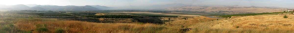
The Hula Valley lies within the northern part of the Syrian-African Rift Valley at an elevation of about 70 meters above sea level, and covers an area of 177 square kilometers (25 km by 6–8 km). On both sides of the valley are steep slopes: the Golan Heights to the east and the Upper Galilee's Naftali mountains to the west rise to 400 to 900 meters above sea level. Basalt hills of about 200 meters above sea level along the southern side of the valley intercept the Jordan River, and are commonly referred to as the basalt "plug", the Korazim block, or Korazim plateau (actually a temporary geologic base level), as they restrict water drainage downstream into the Sea of Galilee.
The Hula Valley has a Mediterranean climate of hot dry summers and cool rainy winters, although its enclosure within two mountain ranges leads to more extreme seasonal and daily temperature fluctuations than in coastal areas. Annual rainfall varies greatly between different parts of the valley and ranges from about 400 millimeters in the south of the valley, to up to 800 millimeters in the north of the valley. More than 1,500 millimeters of precipitation falls on the Hermon mountain range, only a few kilometers north of the valley, mostly in the form of snow, feeding underground springs, including the sources of the Jordan River, all eventually flowing through the valley. The wind regime is dominated by regional patterns in the winter with occasional strong north-easterly wind storms known in Arabic as Sharkiyah.
History


Prior to its drainage in the early 1950s, Lake Hula was 5.3 kilometers long and 4.4 kilometers wide, extending over 12-14 square kilometers. It was about one and a half meters deep in summer and three meters deep in winter. The lake attracted human settlement from early prehistoric times. Paleolithic archaeological remains were found near the Bnot Yaakov ("Daughters of Jacob") bridge at the southern end of the valley. The first permanent settlement, Enan (Mallaha), dates from 9,000-10,000 years ago and was discovered in the valley.
The Hula Valley was a main junction on the important trade route connecting the large commercial centre of Damascus with the eastern Mediterranean coast and Egypt. During the Bronze Age, the cities of Hazor and Laish were built at key locations on this route approximately 4,000 years ago. At some point the area came under Israelite control until it was captured by the Assyrian armies of Tiglath-Pileser III and its inhabitants were driven away. The Bible records lake "Merom" as the site of a victory of Joshua over the Canaanites.[2]
Throughout the Hellenistic, Roman, Byzantine and early Arab periods (fourth century BCE to eighth centuries CE) rural settlement in the Hula Valley was uninterrupted. During the Seleucid Empire, the town Seleucia Samulias was founded on the lake shore.
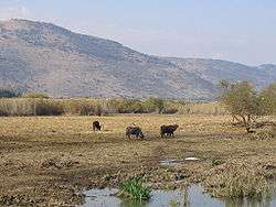
Traditional crops were rice (as early as the Hellenistic period), cotton and sugar cane (brought by the Arabs following their conquest in 636), sorghum and maize (brought after the discovery of the Americas). Water buffalo were introduced in the eighth century supplying milk and serving as beasts of burden.
In the 19th century, the valley, mainly marshy ground and a shallow lake, was inhabited by Ghawaraneh Bedouin[3] who wove matting from the papyrus with which they built their homes. John MacGregor, a Victorian adventurer, was captured with his boat, the "Rob Roy", by dark-skinned Bedouin living in the Hula marshes. He was responsible for the first modern maps of the area.[4] Mortality rates were very high due to the spread of malaria. In 1882, a traveler wrote that the region was "among the finest hunting grounds in Syria," home to "panthers, leopards, bears, wild boars, wolves, foxes, jackals, hyenas, gazelles and otters." During World War II, officers of the British Army wrote about hunting birds there.
In 1908, the Ottoman government granted a concession to drain the marsh to a French firm, which sold it to Lebanese businessmen. In 1933, during the British Mandate, the Palestine Land Development Company took over this concession and drew up plans to drain and irrigate the valley which brought scientific expeditions to the area.[5]

A visitor to the area in the 1930s reported that the villages in the area harvested the papyrus for weaving. They used two distinct styles of loom: one for fine mats for interior use, and a second producing longer, courser mats which were used for constructing huts and shelters.[6]
The first modern Jewish settlement in the Hula Valley, Yesud HaMa'ala on the western shore of the lake, was established in 1883 during the First Aliyah. In 1948 there were 35 villages in the Hula Valley, 12 Jewish and 23 Arab.[7]
Swamp drainage

The draining operations, carried out by the Jewish National Fund (JNF), began in 1951 and were completed by 1958. It was achieved by two main engineering operations: the deepening and widening of the Jordan River downstream; and two newly-dug peripheral canals diverting the Jordan at the north of the valley. The drying out caused the extinction of the unique endemic fauna of the lake, including the cyprinid fish Acanthobrama hulensis[8] and cichlid fish Tristramella intermedia.[9]
Though perceived at the time as a great national achievement for Israel, with the advent of the modern environmental movement, it became evident that the transformation of the swamp into agricultural land involved significant trade offs and had effects on the ecosystem that had not been perceived in the first half of the twentieth century, when the major concerns had been the reduction of malaria-bearing mosquitoes and improving economic productivity. In 1963, a small (3.50 km²) area of recreated papyrus swampland in the southwest of the valley was set aside as the country's first nature reserve. Concern over the draining of the Hula was the impetus for the creation of the Society for the Protection of Nature in Israel.[10]
Draining the Hula turned out to be a mixed blessing. Water polluted with chemical fertilizers began flowing into Lake Kinneret (Sea of Galilee), lowering the quality of its water. The soil, stripped of natural foliage, was blown away by strong winds in the valley, and the peat of the drained swamp ignited spontaneously, causing underground fires that were difficult to extinguish.[11] Eventually part of the valley was transformed back into a wetland habitat.
Hula Nature Reserve
Thanks to the foresight of a number of scientists and nature lovers, at least a small part of Hula's wetlands could be preserved and in 1964 the Hula Nature Reserve was officially inaugurated.[12] The Hula Nature Reserve is listed by the Ramsar Convention on Wetlands, as a Wetland of International Importance .
Hula Lake Park

Hula Lake Park, known in Hebrew as Agmon HaHula (Hebrew: אגמון החולה), is located in the southern part of the Hula Valley, north of the nature reserve and distinct from it. It was established as part of a JNF rehabilitation project.[13] In the early 1990s part of the valley was flooded again in the wake of heavy rains. It was decided to develop the surrounding area and leave the flooded area intact. The new site has become the second home for thousands of migrating birds in the autumn and spring.[14] The lake covers an area of one square kilometer, interspersed with islands that serve as protected bird nesting sites. It has become a major stopover for migrating birds flying from Europe to Africa and back, and also a major birdwatching site. In 2011, Israeli ornithologists confirmed that Lake Hula is the stopover point for tens of thousands of cranes migrating from Finland to Ethiopia every winter. In Israel, farmers set out food for them to keep them from damaging crops near the lake.[15]
Return of Hula painted frog
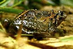
In November 2011 the Hula painted frog, classified as extinct since 1996 by the IUCN as a result of the marsh drainage, reappeared to park patrollers in HaHula. The reappearance was confirmed by the Israel Nature and Parks Authority. Since the discovery of the first specimen at least ten more have been found, all in the same area. The IUCN has accordlingly reclassified the species as Critically Endangered.[16]
Archaeology
Archaeological findings in 2009 show that the hominids who inhabited the area exploited Lake Hula fish. Analysis of the fish remains recovered from the archaeological site of Gesher Benot Ya‘aqov (GBY) have shown that they exploited a wide range of fish including catfish, tilapia and carp. Some of the carp were over a meter long.[17] Tools to light fires and crack nuts were also discovered at the site.[18]
Cultural references
In December 2007 Israel issued a set of three stamps featuring the Hula nature reserve.[19]
See also
- Battle of Lake Huleh
- Museum of Prehistory of the Hulah Valley
- Acanthobrama hulensis
- Tristramella intermedia
References
- ↑ The Hula Reserve
- ↑ Joshua 11:5-7
- ↑ Thomson, W.M. (1872) The Land and the Book; or Biblical Illistrations drawn from the manners and customs, the scenes and scenery of The Holy Land. T. Nelson & son. p. 253
- ↑ History of the Hula Valley
- ↑ History of the Hula Valley
- ↑ Larsson, Theodore (October 1936). "A Visit to the Mat Makers of Huleh". Palestine Exploration Fund Quarterly Statement: 225–229.
- ↑ Tucker, Spencer; Roberts, Priscilla Mary (2008). The Encyclopaedia of the Arab-Israeli conflict: A Political, Social, and Military History. One, A–H. ABC-CLIO. p. 458. ISBN 1851098410.
- ↑ Crevelli, A.J. (2006). "Acanthobrama hulensis". The IUCN Red List of Threatened Species. International Union for Conservation of Nature. Retrieved 2011-06-07.
- ↑ Goren, M. (2006). "Tristramella intermedia". The IUCN Red List of Threatened Species. International Union for Conservation of Nature. Retrieved 2011-06-07.
- ↑ Tal, Alon (2002). Pollution in a Promised Land: An Environmental History of Israel. Berkeley, CA: University of California Press. p. 115. ISBN 978-0-520-23428-4.
- ↑ The Hula Reserve
- ↑ Official webpage of the Hula Nature Reserve at the Israel National Parks Authority website
- ↑ The Hula Valley- Bird Watching Site
- ↑ "The Hula Valley- Bird Watching Site". Haaretz.
- ↑ "Israeli ornithologists confirm flight path of migrating cranes". Haaretz. 2011-03-04.
- ↑ Yong, Ed (2013-06-04). "'Extinct' frog is last survivor of its lineage". Nature. Nature Publishing Group. Retrieved 2013-06-07.
- ↑ Alperson-Afil, Nira; Sharon, Gonen; Kislev, Mordechai; Melamed, Yoel; Zohar, Irit; Ashkenazi, Shosh; Rabinovich, Rivka; Biton, Rebecca; Werker, Ella; Hartman, Gideon; Feibel, Craig; Goren-Inbar, Naama (18 December 2009). "Spatial Organization of Hominin Activities at Gesher Benot Ya'aqov, Israel". Science. 326 (5960): 1677–1680. doi:10.1126/science.1180695. Retrieved February 7, 2001.
- ↑ Goren-Inbar, Naama; Alperson, Nira; Kislev, Mordechai E.; Simchoni, Orit; Melamed, Yoel; Ben-Nun, Adi; Werker, Ella (30 April 2004). "Evidence of Hominin Control of Fire at Gesher Benot Ya`aqov, Israel". Science. 304 (5671): 725–727. doi:10.1126/science.1095443. PMID 15118160. Retrieved February 7, 2001.
- ↑ "Hula Reserve series" (in Hebrew). israelphilately.org.il. Archived from the original on 2011-07-23.
External links
| Wikimedia Commons has media related to Hula Valley. |
- Lake Hula and Lake Agmon, Jewish Virtual Library
- Photos of birds at Hula Valley
- Photos of Hulah Valley
- Photos of Hulah Valley
- The Story of Hula Valley Swamps - Man Versus Nature
Coordinates: 33°6′12″N 35°36′33″E / 33.10333°N 35.60917°E
| Northern District |
|
|---|---|
| Central District |
|
| Southern District | |
| Eilat Region | |
† Located in the Israeli-occupied territories | |