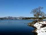
Lake Hibara
Lake Hibara (桧原湖, Hibara-ko) is a lake located in Yama District, Fukushima, Japan. It is a part of the Bandai-Asahi National Park and is the largest of the lakes in the Bandai-kōgen highlands.[1]
A mesotrophic lake, Lake Hibara was formed as a result of the July 15, 1888 eruption of Mount Bandai. The resulting debris avalanche created a natural dam that then filled with water, submerging Hibara Village (桧原村, Hibara-mura). The remains of Hibara Village still lie at the bottom of the lake.[2]
Recreation
A tourist industry has built up around Lake Hibara, offering hiking trails, pleasure cruises, and campgrounds and other lodging. In the winter, ice fishing is popular.
Gallery
| Views of Lake Hibara |
|---|
| Submerged torii from the former location of Hibara Village. |
|
Notes
- ↑ Takeda T., page 174.
- ↑ 裏磐梯を代表する湖沼群 (in Japanese). 裏磐梯観光協会. Retrieved June 30, 2011.
References
- Takeda, Toru; Hishinuma, Tomio; Kamieda, Kinuyo; Dale, Leigh; Oguma, Chiyoichi (August 10, 1988). "Hello! Fukushima - International Exchange Guide Book" (1988 ed.). Fukushima City: Fukushima Mimpo Press