Fucine Lake
| Fucine Lake | |
|---|---|
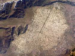 The Fucine Lake as seen from satellite imagery (post-drainage). | |
| Location | Central Italy |
| Coordinates | 41°59′42″N 13°32′50″E / 41.99500°N 13.54722°ECoordinates: 41°59′42″N 13°32′50″E / 41.99500°N 13.54722°E |
| Type | Drainage Lake, Former Lake |
| Primary outflows | Canal |
| Basin countries | Italy |
| Max. length | 10.74 mi (17.28 km) |
| Max. width | 6.74 mi (10.85 km) |
| Surface area | max 140 km2 (54 sq mi) |
| Surface elevation | 2,168 ft (661 m) |
The Fucine Lake (Italian: Lago Fucino or Lago di Celano) was a large endorheic lake in central Italy, stretching from Avezzano in the northwest to Ortucchio in the southeast, and touching Trasacco in the southwest. Once the third largest lake in Italy, it was drained in 1877.
Lore
The former lake is mentioned by Virgil in the Aeneid in book 7, in that it weeps for Umbro, the healer priest killed tragically in battle. (See line 7:882 in the Fagles translation).
Roman drainage
.jpg)
The Romans knew the lake as Fucinus Lacus and founded settlements on its banks, including Marruvium. It was the site of the Battle of Fucine Lake in 89 BC. However, while the lake provided fertile soil and a large quantity of fish, it was also believed to harbour malaria, and, having no natural outflow, repeatedly flooded the surrounding arable land. The Emperor Claudius attempted to control the lake's maximum level by digging a 5.6 km (3.5 mi) tunnel through Monte Salviano, requiring 30,000 workers and eleven years, but with uncertain success.[1] Of the collapse of one of the tunnels Cassius Dio observed
"When the Fucine Lake caved in, the prominent freedman Tiberius Claudius Narcissus was severely blamed for it. For he had been in charge of the undertaking, and it was thought that after spending a good deal less than he had received he had then purposely contrived the collapse, in order that his wrong-doing might not be detected."[2]
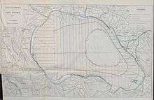
The original lake had a fluctuating area of about 140 km2 (54 sq mi) which the Claudian initiative may have reduced to about 90 km2 (35 sq mi). A 4.5 km (2.8 mi) collecting canal was extended and deepened by Hadrian which reduced the area of the lake to about 57 km2 (22 sq mi). The larger 19th century tunnel, along the same route as the Roman tunnel, destroyed most of the archaeology of the Roman tunnel, which is why the success of the earlier Claudian scheme is so uncertain. The deeper Hadrianic canal destroyed the archaeology of the Claudian canal. The final Roman canal has left clear archaeology, showing that 1 km (0.62 mi) from the lake, the tunnel was 7.5 m (25 ft) deep, 19.5 m (64 ft) wide at the top, and 4.5 m (15 ft) wide at the base. It sloped to the tunnel at 0.05% (a gradient of one in twenty). A very detailed account of the Roman scheme is found in the Brisse & Retrou reference below.
Drain blockage
As the Empire fell, there was a failure to maintain the Roman drainage scheme. Sediment and vegetation blocked the collecting canal. An earthquake on a fault crossing the collecting canal dropped the land on the lake side 30–35 cm (12–14 in) relative to the tunnel entrance. Investigations where the fault crosses the canal show that large amounts of sediment had accumulated in the canal before the earthquake. On the assumption that this earthquake would damage Rome it seems very likely that the earthquake occurred shortly before 508 AD when the earthquake damage to the Colosseum was repaired. The lake appears to have returned to its uncontrolled pre-Claudian area by the end of the 5th century and certainly by the end of the 6th century.
Some suggestion, or attempt, to restore the Roman drainage scheme appears in both the 13th and 15th centuries but neither succeeded.
New drainage
In the 19th century, the Swiss engineer Jean François Mayor de Montricher was commissioned by the prince Alessandro Torlonia to drain the lake. A 6.3 km-long (3.9 mi) and 21 m-wide (69 ft) canal was begun in 1862 and after more than 13 years, the lake was completely drained. The resulting plain is one of Italy's most fertile regions. Antiquities from the Roman occupation of the land, after the first drainage scheme, became part of the Torlonia collection.

See also
- Tulare Lake in California. Once the largest lake in the western United States, it was also drained for agricultural use and flood control purposes in the nineteenth century.
- The Aral Sea on the border between Kazakhstan and Uzbekistan, which used to be the second largest salt lake in the world, was slowly drained to water cotton crops in the 1900s. It is now almost completely dry.
References
- ↑ Suetonius The Twelve Caesars, Claudius 20
- ↑ Cassius Dio, Book LXI.33.5
External links
Further reading
- A. Campanelli (ed.) 2001 Il Tesoro del lago, L'archeologia del Fucino e la collezione Torlonia
- Sandro D'Amati 1960 Il prosciugamento del Fucino, Avezzano
- October 1996 Paleoseismology related to deformed archaeological remains in the Fucino plain Implications for subrecent seismicity in Central Italy Annali di Geofisica
- Cesare Letta 1972 I Marsi e il Fucino nell’antichità, Milan.
- Brisse & Rotrou 1876 Desséchement du Lac Fucino éxécuté par le Prince Alexandre Torlonia (en Juin 1861). The draining of Lake Fucino accomplished by Prince Alexander Torlonia. ([With] An abridged account historical and technical by Messrs. A. Brisse ... and Léon de Rotrou ... English Translation by V. de Tivoli Junr)] Rome
External links
 Chisholm, Hugh, ed. (1911). "Fucino, Lago di". Encyclopædia Britannica. 11 (11th ed.). Cambridge University Press. pp. 273–274.