Argentino Lake
| Argentino Lake / Lago Argentino | |
|---|---|
 Northern arm of the lake | |
| Location | Lago Argentino Department, Santa Cruz Province, Argentina |
| Coordinates | 50°13′S 72°25′W / 50.217°S 72.417°WCoordinates: 50°13′S 72°25′W / 50.217°S 72.417°W |
| Primary outflows | Santa Cruz River |
| Catchment area | 17,000 km2 (6,600 sq mi) |
| Basin countries | Argentina |
| Surface area | 1,415 km2 (546 sq mi)[1] |
| Average depth | 150 m (490 ft) |
| Max. depth | 500 m (1,600 ft) |
| Water volume | 219.9 km3 (52.8 cu mi) |
| Surface elevation | 187 m (614 ft) |
| Settlements | El Calafate |
Lago Argentino is a lake in the Patagonian province of Santa Cruz, Argentina, at 50°2′S 72°4′W / 50.033°S 72.067°W. It is the biggest freshwater lake in Argentina, with a surface area of 1,415 km2 (546 sq mi) (maximum width: 20 mi (32 km)). It has an average depth of 150 m (492 ft), and a maximum depth of 500 m (1,640 ft).
The lake lies within the Los Glaciares National Park in a landscape with numerous glaciers and is fed by the glacial meltwater of several rivers, the water from Lake Viedma brought by the La Leona River, and many mountain streams. Its drainage basin amounts to more than 17,000 km2 (6,564 sq mi). Waters from Lake Argentino flow into the Atlantic Ocean through the Santa Cruz River.
The glaciers, the nearby town of El Calafate and the lake itself are important tourist destinations. The lake in particular is appreciated for fishing. Perch, common galaxias, "puyen grande", lake trout and rainbow trout — in both anadromous and Potamodromous forms — are all found.
Lago Argentino was also the name of the airport that served the area until 2000. This airport is currently closed and its runway was incorporated into the city's road system. It has been replaced by Comandante Armando Tola International Airport which serves the town of El Calafate and Lago Argentino, with many daily national and international flights.
Climate
| Climate data for Lago Argentino Airport | |||||||||||||
|---|---|---|---|---|---|---|---|---|---|---|---|---|---|
| Month | Jan | Feb | Mar | Apr | May | Jun | Jul | Aug | Sep | Oct | Nov | Dec | Year |
| Record high °C (°F) | 30.5 (86.9) |
30.7 (87.3) |
27.0 (80.6) |
22.3 (72.1) |
19.9 (67.8) |
17.5 (63.5) |
16.5 (61.7) |
18.7 (65.7) |
21.8 (71.2) |
23.3 (73.9) |
25.0 (77) |
28.5 (83.3) |
30.5 (86.9) |
| Average high °C (°F) | 19.2 (66.6) |
18.7 (65.7) |
16.2 (61.2) |
12.4 (54.3) |
7.6 (45.7) |
4.8 (40.6) |
4.7 (40.5) |
6.9 (44.4) |
10.5 (50.9) |
14.2 (57.6) |
16.7 (62.1) |
18.5 (65.3) |
12.5 (54.5) |
| Daily mean °C (°F) | 13.4 (56.1) |
13.1 (55.6) |
10.7 (51.3) |
7.6 (45.7) |
3.9 (39) |
1.5 (34.7) |
1.2 (34.2) |
2.6 (36.7) |
5.3 (41.5) |
8.5 (47.3) |
11.2 (52.2) |
12.8 (55) |
7.7 (45.9) |
| Average low °C (°F) | 7.8 (46) |
7.5 (45.5) |
5.2 (41.4) |
2.8 (37) |
−0.3 (31.5) |
−2.4 (27.7) |
−2.8 (27) |
−1.5 (29.3) |
0.1 (32.2) |
2.7 (36.9) |
5.0 (41) |
6.6 (43.9) |
2.6 (36.7) |
| Record low °C (°F) | −0.2 (31.6) |
0.4 (32.7) |
−4.0 (24.8) |
−4.0 (24.8) |
−8.5 (16.7) |
−11.5 (11.3) |
−11.8 (10.8) |
−12.0 (10.4) |
−7.0 (19.4) |
−4.4 (24.1) |
−2.5 (27.5) |
−2.6 (27.3) |
−12.0 (10.4) |
| Average precipitation mm (inches) | 5.9 (0.232) |
4.3 (0.169) |
7.5 (0.295) |
14.0 (0.551) |
19.2 (0.756) |
18.1 (0.713) |
16.3 (0.642) |
16.1 (0.634) |
6.3 (0.248) |
8.7 (0.343) |
3.0 (0.118) |
3.9 (0.154) |
123.3 (4.854) |
| Average precipitation days | 3 | 3 | 4 | 6 | 7 | 6 | 7 | 5 | 3 | 4 | 3 | 2 | 53 |
| Average relative humidity (%) | 48 | 48 | 51 | 59 | 69 | 73 | 73 | 68 | 58 | 51 | 46 | 46 | 58 |
| Mean monthly sunshine hours | 260.4 | 209.1 | 195.3 | 156.0 | 117.8 | 99.0 | 96.1 | 142.6 | 168.0 | 223.2 | 249.0 | 269.7 | 2,186.2 |
| Percent possible sunshine | 52.5 | 51.5 | 50.5 | 48.5 | 42.0 | 39.5 | 35.0 | 43.5 | 48.0 | 52.0 | 54.0 | 53.0 | 47.5 |
| Source #1: Servicio Meteorologico Nacional[2] | |||||||||||||
| Source #2: Secretaria de Mineria(sun, record high and some record lows 1951–1980),[3] NOAA(some record lows 1971–1990)[4] | |||||||||||||
Gallery
-

Argentino seen from the town of El Calafate. -
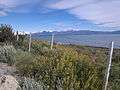
Lake Argentino as seen from the road to Los Glaciares National Park -
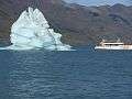
Iceberg and tourist boat on the lake
See also
References
- ↑ "Principales lagos de la república Argentina". ign.gob.ar. Instituto Geográfico Nacional (IGN). 2015. Retrieved 2015-10-03.
- ↑ "Statistical Data (1981–1990)" (in Spanish). National Meteorological Service of Argentina. Retrieved August 14, 2012.
- ↑ "Provincia de Santa Cruz - Clima Y Meteorologia: Datos Meteorologicos Y Pluviometicos" (in Spanish). Secretaria de Mineria de la Nacion (Argentina). Archived from the original on January 19, 2015. Retrieved April 12, 2013.
- ↑ "Lago Argentino Climate Normals 1961–1990". National Oceanic and Atmospheric Administration. Retrieved February 19, 2014.
External links
- Lake Argentino on the website of the International Lake Environment Committee Foundation
- Lago Argentino on the website of the government of Santa Cruz (in Spanish)
- Lago Argentino Airport at World Airport Codes and ICAO World Airfield Catalogue