Lake Amadeus
| Lake Amadeus | |
|---|---|
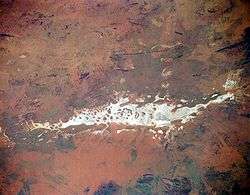 From space (November 1994) | |
| Location | Northern Territory |
| Coordinates | 24°48′S 130°54′E / 24.8°S 130.9°ECoordinates: 24°48′S 130°54′E / 24.8°S 130.9°E |
| Type | Salt lake |
| Basin countries | Australia |
| Max. length | 180 km |
| Max. width | 10 km |
| Surface area | 1032 km² |
Lake Amadeus is a large salt lake in the southwest corner of Australia's Northern Territory, about 50 km north of Uluru (Ayers Rock). The smaller Lake Neale is adjacent to the northwest. It is part of (or a surface feature of) the Amadeus Basin that was filled with the erosion products of the Petermann Orogeny.
Physical features and nearby landmarks
Due to the aridity of the area, the surface of Lake Amadeus is usually a dry salt crust. In times of sufficient rainfall, it is part of an east-flowing drainage system that eventually connects to the Finke River.
Lake Amadeus is 180 kilometres (110 mi) long and 10 kilometres (6.2 mi) wide, making it the largest salt lake in the Northern Territory.[1]
Lake Amadeus contains up to 600 million tonnes of salt; however, harvesting it has not proved viable, owing to its remote location.
Nearby landmarks are Uluru, Kata Tjuta (previously called The Olgas), and Mount Conner.
Discovery by Europeans
The first European to discover the lake, the explorer Ernest Giles, encountered it in 1872. Giles originally intended to honour his benefactor Baron Ferdinand von Mueller with the eponym Lake Ferdinand. However, Mueller prevailed upon Giles to instead honour King Amadeo I of Spain (reigned 1870-1873, known in English as King Amadeus I), who had previously bestowed honour on him. The lake's expanse proved a barrier for Giles, who could see both the as yet undiscovered Ayers Rock and Kata Tjuta but could not reach them as the dry lake bed wasn't able to support the weight of his horses.[2] The next year, William Gosse climbed and named both rises.
See also
References
- ↑ "Largest Waterbodies". Geoscience Australia. Commonwealth of Australia. 23 December 2009. Retrieved 13 May 2010.
- ↑ Stanton, Jenny (2000). The Australian Geographic Book of the Red Centre. Terrey Hills, New South Wales: Australian Geographic. p. 44. ISBN 1-86276-013-6.