Lajes (Praia da Vitória)
| Lajes | |
| Civil Parish | |
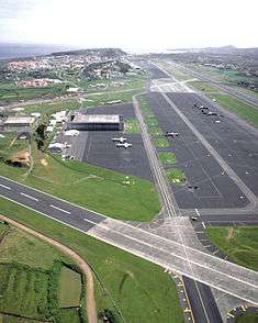 The northern portion of Lajes Airfield; the parish of Lajes is dominated geographically and economically by the importance of Air Base No.4 | |
| Official name: Freguesia de Lajes | |
| Name origin: Portuguese for tough rock | |
| Country | |
|---|---|
| Autonomous Region | |
| Island | Terceira |
| Municipality | Praia da Vitória |
| Localities | Fundões, Caldeira, Canada da Caldeira, Canada das Fontainhas, Canada das Vinhas, Canada do Poço, Lajedo, Lajes, Picão, Rebentão, Santa Rita |
| Center | Lajes |
| - elevation | 63 m (207 ft) |
| - coordinates | 38°45′45″N 27°6′21″W / 38.76250°N 27.10583°WCoordinates: 38°45′45″N 27°6′21″W / 38.76250°N 27.10583°W |
| Highest point | Santa Rita |
| - elevation | 112 m (367 ft) |
| - coordinates | 38°45′34″N 27°4′47″W / 38.75944°N 27.07972°W |
| Lowest point | Sea level |
| - location | Atlantic Ocean |
| - elevation | 0 m (0 ft) |
| Area | 12.11 km2 (5 sq mi) |
| - water | .00 km2 (0 sq mi) |
| - urban | 3.14 km2 (1 sq mi) |
| Population | 3,744 (2011) |
| Density | 309/km2 (800/sq mi) |
| Settlement | fl. 1500 |
| - Parish | fl. 3 April 1507 |
| - Civil Parish | fl. 1614 |
| - Vila/Town | 12 June 2002 |
| LAU | Junta Freguesia |
| - location | Rua Padre Gregório Rocha |
| - coordinates | 38°46′2″N 27°6′13″W / 38.76722°N 27.10361°W |
| President Junta | Luís Filipe Gomes Aguiar (PS) |
| President Assembleia | Elmano Manuel Vieira Nunes (PS) |
| Timezone | Azores (UTC-1) |
| - summer (DST) | Azores (UTC0) |
| Postal Zone | 9760-292 |
| Area Code & Prefix | (+351) 292 XXX XXX |
| Demonym | Lajense |
| Patron Saint | São Miguel Arcanjo |
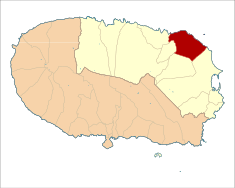 Location of the parish seat of Lajes on the island of Terceira | |
| Wikimedia Commons: Lajes (Praia da Vitória) | |
| Website: http://www.jflajes.com | |
| Geographic detail from Instituto Geográfico Português (2010) | |
Lajes is a civil parish in the municipality of Praia da Vitória, on the Portuguese island of Terceira in the Azores. The population in 2011 was 3,744,[1] in an area of 12.11 square kilometres (4.68 sq mi).[2] It is the second most populous parish in the municipality of Praia da Vitória.
Lajes is best known for being the location of Portuguese Air Force Base No.4, used for military, small inter-island, as well as scheduled and chartered flights from North America and mainland Europe. The U.S. military has a multi-year agreement with the government of Portugal at Lajes Airfield, which is the base for U.S. 65th Air Base Wing (65 ABW).
History
Although the date of Lajes elevation to status of ecclesiastical or civil parish is unknown, there is reference to the navigator Pero de Barcelos, who was one of the first settlers in the region, dating to 3 April 1507.[3]
Even the date of the construction of the primitive temple are unknown, and rather the date of its destruction during the 1641 Caída da Praia earthquake is the only reference made to the religious structure.[3] At the time three of the captaincies of Praia were destroyed, along with many of the buildings in the town of Praia, and parishes of Fontinhas, Lajes, Vila Nova and Agualva.[3]
Owing to the natural qualities, Lajes was always the preferred residency of the rich and noble families, resulting in it being referred to as A Madrid dos Açores (The Madrid of the Azores).[3] Many of the estates and lands supported the island of Terceira, and was usually referred as the Celeiro da Terceira (the breadbasket of Terceira). There are also registered several references to the quantity and quality of the produce in the region, including fruit and wine, in addition to silk production. Lajes is located on a vast fertile plain, divided by hedge rows and where many old signeurial homes still reflect the importance of farming and prosperity of the traditional families of the island.[3] Today, many of the modern roadways that intersect the parish, were once used by farmers to transport goods, usually using the large Ramo Grande oxen, pulling large carts, crafted to transport large, weighty loads, without putting undue stress on the animals.[3] Wood would normally be transported, burned to maintain the warmth during the winter, or for cooking bread in earthen ovens.[3] The oxen, the signeurial homes and agricultural community became known as the Ramo Grande.[3]
Along with Santa Cruz, Lajes also became the focus, during the Second and Post-Second World War of British and American forces stationed at Area Base No. 4, supporting the and providing a dynamic economic innovator for the parish and region.[3]
Geography
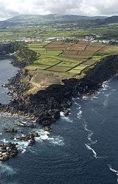
Lajes is situated on the northern coast of Terceira, bordered on the west by the parishes of Vila Nova and São Brás, to the east by Santa Cruz and south, by the parish of Fontinhas. The majority (over half) of the parish is occupied by Air Base No. 4, and the barracks/homes of Air Force personnel stationed on the base (including American and Portuguese servicemen). The remainder of the base is actually in the neighbouring civil parish of Santa Cruz.
The western frontier is delineated by the Ribeira da Areia that crosses into the interior, reaching the parishes of Vila Nova and São Brás. The border then skirts Lorais, until Fundões, and parts towards the interior again, intersecting at Rua do Terreiro, Rua das Covas, Rua dos Fundões and Rua Padre Gregório B. Rocha, before arriving in Picão. The border then passes through the pasturelands of the interior, before aligning with the regional roadway at Santa Luzia, and running perpendicular towards the regional airport, bisecting the runway in the direction of Santa Rita, until the coast at Ponta dos Carneiros.
In addition to Ribeira da Areia and Ribeira dos Pães, the parish is crossed by subterranean branches of the Ribeira do Marques (that crosses the airport/air base).
Climate
| Climate data for Lajes (Lajes Airport) | |||||||||||||
|---|---|---|---|---|---|---|---|---|---|---|---|---|---|
| Month | Jan | Feb | Mar | Apr | May | Jun | Jul | Aug | Sep | Oct | Nov | Dec | Year |
| Record high °C (°F) | 21.1 (70) |
21.1 (70) |
22.2 (72) |
23.9 (75) |
24.4 (75.9) |
27.8 (82) |
28.9 (84) |
30.0 (86) |
30.0 (86) |
28.3 (82.9) |
23.9 (75) |
22.2 (72) |
30.0 (86) |
| Average high °C (°F) | 16.1 (61) |
16.1 (61) |
16.7 (62.1) |
17.2 (63) |
18.9 (66) |
21.1 (70) |
23.3 (73.9) |
24.4 (75.9) |
23.3 (73.9) |
21.1 (70) |
18.3 (64.9) |
17.2 (63) |
19.4 (66.9) |
| Daily mean °C (°F) | 14.4 (57.9) |
13.9 (57) |
14.5 (58.1) |
14.9 (58.8) |
16.4 (61.5) |
18.7 (65.7) |
21.0 (69.8) |
22.1 (71.8) |
21.1 (70) |
18.6 (65.5) |
16.7 (62.1) |
15.2 (59.4) |
17.3 (63.1) |
| Average low °C (°F) | 12.2 (54) |
11.7 (53.1) |
11.7 (53.1) |
12.2 (54) |
13.9 (57) |
16.1 (61) |
17.8 (64) |
18.9 (66) |
17.8 (64) |
16.1 (61) |
14.4 (57.9) |
12.8 (55) |
14.4 (57.9) |
| Record low °C (°F) | 2.8 (37) |
4.4 (39.9) |
5.0 (41) |
5.6 (42.1) |
7.2 (45) |
7.8 (46) |
11.7 (53.1) |
12.2 (54) |
11.1 (52) |
8.3 (46.9) |
5.6 (42.1) |
5.6 (42.1) |
2.8 (37) |
| Average precipitation mm (inches) | 154.7 (6.091) |
137.9 (5.429) |
143.0 (5.63) |
75.7 (2.98) |
49.5 (1.949) |
37.9 (1.492) |
43.7 (1.72) |
44.7 (1.76) |
75.2 (2.961) |
129.5 (5.098) |
128.0 (5.039) |
118.9 (4.681) |
1,138.7 (44.831) |
| Average precipitation days (≥ 0.1 mm) | 19 | 17 | 18 | 13 | 12 | 9 | 7 | 9 | 12 | 16 | 17 | 18 | 167 |
| Average relative humidity (%) | 79 | 79 | 79 | 77 | 78 | 79 | 78 | 77 | 78 | 78 | 80 | 79 | 78 |
| Mean monthly sunshine hours | 104 | 109 | 136 | 159 | 197 | 203 | 230 | 236 | 199 | 152 | 110 | 89 | 1,924 |
| Source: Deutscher Wetterdienst (sun, 1961–1990)[4][5][lower-alpha 1] | |||||||||||||
Economy
Owing to the significance and importance of the regional air field, the economy of Lajes has a symbiotic relationship with the activities at Air Base No.4. Most of the auxiliary staff at the base are residents of Lajes, and many services in the parish support the international demands of the stationed personal. Although most services are provided on base for servicemen, there are still trickle-down affects to the local community, with support personnel living in the parish and spending their money in the local economy. At the same time, it is common for foreign servicemen to support the local economy, when not on duty.
Local activities include carpentry shops, services directed to farmers, automobile and mechanical garages, video, graphic and promotional services and financial institutions, including branches of the national and regional banks (Montepio, Banif, etc.). In addition, several shops, mini-markets, fruit stands and groceries service the local residents with bakeries, a butcher shop, and hairstylists.
Architecture
Lajes has several elementary schools with the main one located in Aldeia Nova. It has two churches with the main one dating back to the 16th century. This church has been destroyed by earthquakes in 1614 and 1841 and partially destroyed on the 1 January 1980 earthquake. The other smaller church is located in Cabouco.
Civic
- Fountain of Ribeira da Areia (Portuguese: Chafarizes da Ribeira da Areia)
- Fountain of Malícias (Portuguese: Chafarizes das Malícias)
- Fountain of Largo de S. João (Portuguese: Chafariz do Largo de S. João)
- Fountain of Remédios (Portuguese: Chafariz dos Remédios)
- Fountain of the Cruzeiro (Portuguese: Chafariz do Cruzeiro)
- Fountain of Picão (Portuguese: Chafariz do Picão)
- Washhouse of Ribeira dos Pães (Portuguese: Pias de levar da Ribeira dos Pães)
- Fountain of the Caldeira (Portuguese: Fonte da Caldeira)
Religious
- Church of the Archangel Michael (Portuguese: Igreja de São Miguel Arcanjo)
- Hermitage of Our Lady of Remedies (Portuguese: Ermida de Nossa Senhora dos Remédios)
- Hermitage of the Immaculate Heart of Mary (Portuguese: Ermida do Imaculado Coração de Maria)
- Liturgical Centre of the Serra de Santiago (Portuguese: Centro de culto da Serra de Santiago)
References
- ↑ Instituto Nacional de Estatística
- ↑ Eurostat
- 1 2 3 4 5 6 7 8 9 Junta Freguesia, ed. (2013), História (in Portuguese), Junta de Freguesia de Lajes, retrieved 31 December 2015
- ↑ "Klimatafel von Lajes (Flugh.) / Insel Terceira; Azoren / Portugal" (PDF). Baseline climate means (1961-1990) from stations all over the world (in German). Deutscher Wetterdienst. Retrieved 30 January 2016.
- ↑ "Station 08509 Lajes (Acores)". Global station data 1961–1990—Sunshine Duration. Deutscher Wetterdienst. Retrieved 30 January 2016.
Notes
- ↑ Station ID for Lajes (Acores) is 08509 Use this station ID to locate the sunshine duration
Sources
- Meneses, Avelino de Freitas de (1991), As Lajes da Ilha Terceira: aspectos da sua história (in Portuguese), Angra do Heroísmo (Azores), Portugal: Blu Edições, ISBN 972-95135-8-9