Lai-Hka
"Laihka" redirects here. For the present-day administrative division, see Lai-Hka Township. For the former Shan princely state, see Laihka State.
| Lai-Hka ဝဵင်းလၢႆးၶႃႈ | |
|---|---|
| Town | |
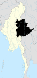
 Lai-Hka Location in Burma | |
| Coordinates: 21°16′20″N 97°39′10″E / 21.27222°N 97.65278°ECoordinates: 21°16′20″N 97°39′10″E / 21.27222°N 97.65278°E | |
| Country |
|
| State | Shan State |
| District | Loilem District |
| Township | Lai-Hka Township |
| Elevation[1] | 971 m (3,186 ft) |
| Time zone | MST (UTC+6.30) |
Lai-Hka (ဝဵင်းလၢႆးၶႃႈ) is a town of Loilen District in the Shan State of Myanmar. It is the capital of Lai-Hka Township.
History
Lai-Hka (ဝဵင်းလၢႆးၶႃႈ)was formerly the capital of Legya state, one of the Southern Shan States. It is 3,116ft above sea leverl at the eastern border of Kesee and Nam Zang. In the south it connects with Panglong and Loilem. In the west, its neighbouring town is Lokjok and Merng Klueng from the north. The total area of Lai-Hka Township is 914.92 sq.miles and it is divided into 7 sections. The rural part of the township is divided into eighteen sub-quarters. The total numbers of village are 180 and the population of the entire town is more than 60,000. Farming is the main industry in Lai-Hka.
References
Capital: Lai-Hka | |
|

This article is issued from Wikipedia - version of the 11/17/2015. The text is available under the Creative Commons Attribution/Share Alike but additional terms may apply for the media files.