Lafayette, Virginia
Lafayette is a census-designated place (CDP) between the cities of Roanoke and Christiansburg in eastern Montgomery County, southwest Virginia. The population as of the 2010 Census was 449.[1] It is located adjacent to Elliston, at the confluence of the North and South Forks of the Roanoke River.
The Lafayette Historic District was listed on the National Register of Historic Places in 1991.[2]
Climate
The climate in this area is characterized by hot, humid summers and generally mild to cool winters. According to the Köppen Climate Classification system, Lafayette has a humid subtropical climate, abbreviated "Cfa" on climate maps.[3]
References
- ↑ Virginia Trend Report 2: State and Complete Places (Sub-state 2010 Census Data). Missouri Census Data Center. Accessed 2011-06-08.
- ↑ National Park Service (2010-07-09). "National Register Information System". National Register of Historic Places. National Park Service.
- ↑ Climate Summary for Lafayette, Virginia
Coordinates: 37°14′10″N 80°12′41″W / 37.23611°N 80.21139°W
Municipalities and communities of Montgomery County, Virginia, United States | ||
|---|---|---|
| Towns | 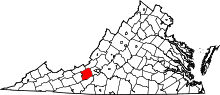 | |
| CDPs | ||
| Unincorporated communities | ||
| Footnotes | ‡This populated place also has portions in an adjacent county or counties | |
This article is issued from Wikipedia - version of the 9/4/2016. The text is available under the Creative Commons Attribution/Share Alike but additional terms may apply for the media files.