Lachaussée
| Lachaussée | |
|---|---|
 Lachaussée | |
|
Location within Grand Est region  Lachaussée | |
| Coordinates: 49°02′16″N 5°49′10″E / 49.0378°N 5.8194°ECoordinates: 49°02′16″N 5°49′10″E / 49.0378°N 5.8194°E | |
| Country | France |
| Region | Grand Est |
| Department | Meuse |
| Arrondissement | Arrondissement of Commercy |
| Canton | Canton of Vigneulles-lès-Hattonchâtel |
| Intercommunality | Communauté de communes du pays de Vigneulles les Hattonchâtel |
| Government | |
| • Mayor (2008–2014) | Gérard Peltre |
| Area1 | 27.19 km2 (10.50 sq mi) |
| Population (1999)2 | 256 |
| • Density | 9.4/km2 (24/sq mi) |
| Time zone | CET (UTC+1) |
| • Summer (DST) | CEST (UTC+2) |
| INSEE/Postal code | 55267 / 55210 |
| Elevation |
203–238 m (666–781 ft) (avg. 218 m or 715 ft) |
|
1 French Land Register data, which excludes lakes, ponds, glaciers > 1 km² (0.386 sq mi or 247 acres) and river estuaries. 2 Population without double counting: residents of multiple communes (e.g., students and military personnel) only counted once. | |
Lachaussée is a commune in the Meuse department in Grand Est in north-eastern France.
Geography
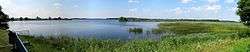
L'étang de Lachaussée
The village of Lachaussée lies on the south-eastern rim of a huge pond named Étang de Lachaussée, which was created during the middle ages from a marsh area and then devoted to pisciculture.
See also
| Wikimedia Commons has media related to Lachaussée. |
This article is issued from Wikipedia - version of the 11/6/2016. The text is available under the Creative Commons Attribution/Share Alike but additional terms may apply for the media files.