Lacey V. Murrow Memorial Bridge
| Lacey V. Murrow Memorial Bridge | |
|---|---|
 The Lacey V. Murrow Memorial Bridge (right) and the Homer M. Hadley Memorial Bridge (left), looking east toward Mercer Island | |
| Carries |
|
| Crosses | Lake Washington |
| Locale | Seattle / Mercer Island, Washington, USA |
| Maintained by | Washington State DOT |
| Characteristics | |
| Design | Pontoon bridge |
| Total length | 6,620 ft (2,020 m) |
| History | |
| Opened | July 2, 1940 |
The Lacey V. Murrow Memorial Bridge is one of the Interstate 90 floating bridges that carries the eastbound lanes of Interstate 90 across Lake Washington from Seattle to Mercer Island, Washington. Westbound traffic is carried by the Homer M. Hadley Memorial Bridge running parallel to it. The Lacey V. Murrow Memorial Bridge is the second-longest floating bridge on Earth at 6,620 ft (2,020 m), whereas the longest is the Governor Albert D. Rosellini Bridge—Evergreen Point just a few miles to the north on the same lake, opened 76 years later. The third-longest is the Hood Canal Bridge, also in Washington State, about 30 miles (48 km) to the northwest of the Evergreen Point Floating Bridge.
Along with the east portals of the Mount Baker Ridge Tunnel, the bridge is an official City of Seattle landmark.[1] While the bridge originally had an opening span at the center of the bridge to allow a horizontal opening of 202 feet (62 m) for major waterborne traffic, the only boat passages currently are elevated fixed spans at the termini with 29 feet (8.8 m) of vertical clearance.[2]
History
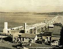
The bridge was the brainchild of engineer Homer Hadley, who had made the first proposal in 1921.[3] The bridge came about after intensive lobbying, particularly by George Lightfoot, who came to be called the "father of the bridge." Lightfoot began campaigning for the bridge in 1930, enlisting the support of Miller Freeman.[4][5][6] Construction began January 1, 1939 and was completed in 1940.[7] The construction cost for the project, including approaches, was approximately $9,000,000. It was partially financed by a bond issue of $4,184,000.[8] Tolls were removed in 1949.[9] The bridge sank in a storm on November 25, 1990 while it was undergoing refurbishing and repair.[10] The current bridge was built in 1993. The eponymous Lacey V. Murrow was the second director of the Washington State Highway Department and a highly decorated US Air Force officer who served in World War II. He was the oldest brother of CBS commentator Edward R. Murrow.[11]
Formerly known as the Lake Washington Floating Bridge, the original bridge was built under a 1 1/2-year contract awarded to the Puget Sound Bridge and Dredging Company (the project was led by engineer Peter John Jensen) in the amount of $3,254,000.[12] It included a movable span that could be retracted into a pocket in the center of the fixed span to permit large boats to pass. This design resulted in a roadway "bulge" that required vehicles to swerve twice across polished steel joints as they passed the bulge. A reversible lane system, indicated by lighted overhead lane control signals with arrow and 'X' signs, compounded the hazard by putting one lane of traffic on the "wrong" side of the bulge at different times of day in an effort to alleviate rush-hour traffic into or out of Seattle. There were many serious collisions on the bridge. The problems grew worse as the traffic load increased over the years and far outstripped the designed capacity. Renovation or replacement was essential and a parallel bridge, the Homer M. Hadley Memorial Bridge, was completed in 1989.
1990 disaster

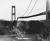
In 1990, while under construction, the original bridge sank because of a series of human errors and decisions. The process started because the bridge needed resurfacing and was to be widened by means of cantilevered additions in order to meet the necessary lane-width specifications of the Interstate Highway System. The Washington State Department of Transportation (WSDOT) decided to use hydrodemolition (high-pressure water) to remove unwanted material (the sidewalks on the bridge deck). Water from this hydrodemolition was considered contaminated under environmental law and could not be allowed to flow into Lake Washington.[13] Engineers then analyzed the pontoons of the bridge, and realized that they were over-engineered and the water could be stored temporarily in the pontoons. The watertight doors for the pontoons were therefore removed.
A large storm on November 22–24, 1990 (the Thanksgiving holiday weekend) filled some of the pontoons with rain and lake water. On November 24, workers noticed that the bridge was about to sink, and started pumping out some of the pontoons. However, on November 25, 2,790 ft (850 m) of the bridge sank, dumping the contaminated water into the lake along with tons of bridge material. The bridge sank when one pontoon filled and dragged the rest down because they were cabled together and there was no way to separate the sections under load. No one was hurt or killed, since the bridge was closed for renovation and the sinking took some time. All of the sinking was captured on film and shown on live TV. The cost of the disaster was $69 million in damages.
Precedents and lessons learned
WSDOT had lost another floating bridge, the Hood Canal Bridge, about a decade earlier under similar circumstances. It is now known that another major floating bridge in Washington, the Evergreen Point Floating Bridge, was under-engineered for local environmental conditions; that bridge was replaced with a new floating span in 2016.[14]
See also
-
 Bridges portal
 -
 Washington portal
 -
 Seattle portal
 - List of bridges in Seattle
- Homer M. Hadley Memorial Bridge
Notes
- ↑ Landmarks Alphabetical Listing for L, Individual Landmarks, Department of Neighborhoods, City of Seattle. Accessed December 28, 2007.
- ↑ Tudor Engineering Company for Washington State Highway Commission Department of Highways. Legislative Reconnaissance and Feasibility Report "Lake Washington Bridge Crossings, Parallel Evergreen Point Bridge, North Lake Bridge. December 1968.
- ↑ Burrows, Alyssa (January 18, 2005). "Homer Hadley formally proposes a concrete pontoon floating bridge across Lake Washington on October 1, 1921.". HistoryLink. Retrieved September 19, 2015.
- ↑ "G. W. Lightfoot Taken By Death". The Seattle Times. April 18, 1941.
- ↑ Reynolds, Peggy (May 24, 1989). "George Lightfoot's Vision Spanned Lake Washington". The Seattle Times. p. H1. Retrieved September 19, 2015 – via NewsBank. (subscription required (help)).
- ↑ Brahm, Jane Meyer (2013). Mercer Island History: From Haunted Wilderness to Coveted Community. Island Books.
- ↑ Zylstra, Brian (January 28, 2011). "Building the first Lake Washington floating bridge". From Our Corner. Washington Office of the Secretary of State. Retrieved September 19, 2015.
- ↑ Tudor Engineering Company for Washington State Highway Commission Department of Highways. Legislative Reconnaissance and Feasibility Report "Lake Washington Bridge Crossings, Parallel Evergreen Point Bridge, North Lake Bridge. December 1968.
- ↑ "Floating Bridge Pays For Itself". The Southeast Missourian. Newspaper Enterprise Association. July 19, 1949. p. 3. Retrieved May 18, 2010 – via Google News Archive.
- ↑ "Pontoon Bridge Sinks in Flooding As Seattle Is Battered by Storms". The New York Times. Associated Press. November 26, 1990. Retrieved September 19, 2015.
- ↑ Oldham, Kit (March 16, 2005). "Lacey V. Murrow becomes Director of Highways on March 20, 1933". HistoryLink. Retrieved October 25, 2007.
- ↑ Schmitt, F.E. (January 5, 1939). "Low Bidder Get Contract on Pontoon Bridge". Engineering News-Record. New York: McGraw-Hill Publishing Company. 122 (1): 5. Retrieved December 28, 2008 – via Google Books.
- ↑ Donald O. Dusenberry, et al. (Feb. 1995). "Failure of Lacey V. Murrow floating bridge, Seattle, Washington." Journal of Performance of Constructed Facilities, v. 9, n. 1, p 4-23.
- ↑ "SR 520 - Floating Bridge and Landings Project". Washington State Department of Transportation. Retrieved September 19, 2015.
External links
- Lacey V. Murrow Floating Bridge at Structurae
- Bridge Camera, includes some weather information
- HAER Survey number HAER WA-2 – Lacey V. Murrow Memorial Floating Bridge, Spanning Lake Washington at I-90, Seattle, King County, WA
- King-5 television video of the sinking
Coordinates: 47°35′24″N 122°16′13″W / 47.58988°N 122.27031°W
Washington State bridge disasters and incidents | ||
|---|---|---|
| Complete losses |
|  |
| Partial losses |
| |
| Incidents | ||