Lac de Montbel
| Lac de Montbel | |
|---|---|
 Lac de Montbel | |
| Coordinates | 42°58′33″N 1°57′31″E / 42.97583°N 1.95861°ECoordinates: 42°58′33″N 1°57′31″E / 42.97583°N 1.95861°E |
| Type | Reservoir |
| Built | 1982 to 1985 |
| Surface area | 550 hectares (1,400 acres) |
| Max. depth | 42 m |
| Water volume | 60,000,000 cubic metres (1.6×10¹⁰ US gal) |
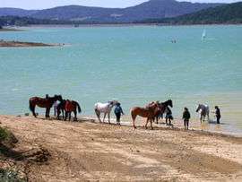
The Lac de Montbel is a reservoir 5 minutes from Chalabre, which is a popular location for watersports and swimming. It is located at Sainte-Colombe-sur-l'Hers on the border between the Ariège and Aude départements of southwestern France.
The flooded hillsides are still evident when the water level drops, revealing tree stumps and the thick sticky clay (marl) so typical of the Ariège. On quiet hot summer days the water takes on a beautiful turquoise colour which is very photogenic.
The area is relatively undeveloped and quiet and privacy are a great attraction. The mountains of the Pyrenees are visible in the background.
Other lakes for swimming near Montbel include Lac de la Cavayère and a smaller one at Pradelles-Cabardès.
The dam which created the reservoir was built between 1982 and 1985.[1]
References
- ↑ "Dossier départemental des risques majeurs - Barrage de Montbel". Préfecture de l'Aude. Retrieved 4 February 2010.
- "Lac de Montbel". Communauté de Communes du Pays de Mirepoix. Retrieved 4 February 2010.
External links
| Wikimedia Commons has media related to Lac de Montbel. |