Lac d'Enghien
| Lac d'Enghien | |
|---|---|
| Location | Enghien-les-Bains, Île-de-France |
| Coordinates | 48°58′15″N 02°18′00″E / 48.97083°N 2.30000°ECoordinates: 48°58′15″N 02°18′00″E / 48.97083°N 2.30000°E |
| Primary outflows | rû d'Enghien |
| Catchment area | 70.38 km2 (27.17 sq mi) |
| Basin countries | France |
| Max. length | 930 m (3,050 ft) |
| Max. width | 350 m (1,150 ft) |
| Surface area | 43 ha (110 acres) |
| Average depth | 1.8 m (5 ft 11 in) |
| Max. depth | 2.55 m (8 ft 4 in) |
| Surface elevation | 43 m (141 ft) |
| Islands | 2 |
Lac d'Enghien is a freshwater lake in France.
Geography
Lac d'Enghien is in the Île-de-France region, approximately seven miles north of Paris. Administratively it belongs to the commune of Enghien-les-Bains in the department of Val-d'Oise. It is the department's largest body of water.[1]
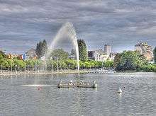
Fountain and pier at Lac d'Enghien
Features
The lake is roughly 350 metres (1,150 ft) wide and 930 metres (3,050 ft) long, with a circumference of 3.09 kilometres (1.92 mi) and a total surface area of 43 hectares (110 acres).[2] The lake water is replenished by several small streams: the Corbon, Haras, d'Ermont, and d'Andilly, all of them under 8 kilometres (5.0 mi) long .[3]
See also
References
- ↑ "Relief, géologie et hydrographie" (in French). Direction départementale des Territoires du Val d’Oise (DDT). 2009. Retrieved 17 July 2011.
...lac d’Enghien, plan d’eau le plus important du département.
- ↑ "Joyau Naturel: Lac d'Enghien" (in French). Office de Tourisme, Enghien-les-Bain. 2011. Retrieved 17 July 2011.
- ↑ "Fiche du bassin versant du lac d'Enghien" (in French). Institut d'amanagement et d'urbanisme de la region Île-de-France (IAURIF). 2007. Archived from the original on November 18, 2006. Retrieved 17 July 2011.
| Wikimedia Commons has media related to Lac d'Enghien. |
This article is issued from Wikipedia - version of the 3/31/2016. The text is available under the Creative Commons Attribution/Share Alike but additional terms may apply for the media files.