Lac Saint-Jean
| Lac Saint-Jean (Piekuakami) | |
|---|---|
 | |
 Location in Quebec | |
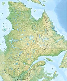
| Location | Saguenay–Lac-Saint-Jean region, Quebec |
| Coordinates | 48°35′40″N 72°01′48″W / 48.59444°N 72.03000°WCoordinates: 48°35′40″N 72°01′48″W / 48.59444°N 72.03000°W |
| Type | impact crater lake |
| Primary inflows | Ashuapmushuan, Mistassini, Peribonka, Des Aulnaies, Métabetchouan, Ouiatchouane |
| Primary outflows | Saguenay River |
| Catchment area | 71,947 km2 (27,779 sq mi) |
| Basin countries | Canada |
| Max. length | 43.8 km (27.2 mi) |
| Max. width | 24 km (15 mi) |
| Surface area | 1,053 km2 (407 sq mi) |
| Average depth | 11.4 m (37 ft) |
| Max. depth | 63.1 m (207 ft) |
| Water volume | 11.9 km3 (2.9 cu mi) |
| Surface elevation | 99.6 m (327 ft) |
| References | [1] |
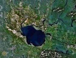
Lac Saint-Jean is a large, relatively shallow lake in south-central Quebec, Canada, in the Laurentian Highlands. It is situated 206 kilometres north of the Saint Lawrence River, into which it drains via the Saguenay River. It covers an area of 1,053 km2 (407 sq mi), and is 63.1 m (207 ft) at its deepest point. The water is reddish yellow. Its name in the Innu language is Piekuakami.[2]
Description
The lake is fed by dozens of small rivers, including the Ashuapmushuan, the Mistassini, the Peribonka, the Des Aulnaies, the Métabetchouane, and the Ouiatchouane. The towns on its shores include Alma, Dolbeau-Mistassini, Roberval, Normandin, and Saint-Félicien. Three Regional County Municipalities lie on its shores: Lac-Saint-Jean-Est, Le Domaine-du-Roy, and Maria-Chapdelaine.
The lake was named Piekuakami by the Innu, the indigenous people who occupied the area at the time of European arrival. It was given its French name after Jean de Quen, a Jesuit missionary who in 1647 was the first European to reach its shores.
Industry on the lake was dominated by the fur trade until the 19th century. Colonization began in the Saguenay–Lac-Saint-Jean region in the early 19th century and continued intensively until the early 20th century. Industry was mainly forestry and agriculture. In the 20th century, pulp and paper mills and aluminum smelting rose to importance, encouraged by hydroelectric dams at Alma and on the Péribonka River. Lac Saint-Jean also has an important summer resort and sport-fishing industry.
The area is featured in the classic French language novel Maria Chapdelaine by Louis Hémon published in 1914 and subsequently translated into twenty languages.
In the 1940s, during World War II, Lac Saint-Jean, along with various other regions within Canada, such as the Saguenay, Saint Helen's Island and Hull, Quebec, had Prisoner-of-war camps.[3] Lac Saint-Jean's was numbered and remained unnamed just like most of Canada's other war prisons.[3][4] The prisoners of war (POWs) were classified into categories including their nationality and civilian or military status.[3] By 1942 this region had two camps with at least 50 POWs. Prisoners worked the land, including lumbering and assisting in the production of pulp and paper.[3]
Notable people
- Birthplace of NHL Hall of Famer and Team Canada 1972 member Jean Ratelle.
- Birthplace of McGill Professor Mario Chevrette, Ph.D of Molecular and Cell Biology.
See also
References
- ↑ "LAC SAINT-JEAN (LAKE SAINT-JOHN)". ILEC-Logo International Lake Environment Committee. Retrieved 31 December 2012.
- ↑ Innu-aimun.ca: Piekuakami
- 1 2 3 4 Tremblay, Robert, Bibliothèque et Archives Canada, et all. "Histoires oubliées – Interprogrammes : Des prisonniers spéciaux" Interlude. Aired: 20 July 2008, 14h47 to 15h00.
- ↑ Note: See also List of POW camps in Canada.
External links
| Wikimedia Commons has media related to Lac Saint-Jean. |
 Lac-Saint-Jean travel guide from Wikivoyage