Labège
| Labège | ||
|---|---|---|
 | ||
| ||
 Labège | ||
|
Location within Occitanie region  Labège | ||
| Coordinates: 43°31′48″N 1°31′51″E / 43.53°N 1.5308°ECoordinates: 43°31′48″N 1°31′51″E / 43.53°N 1.5308°E | ||
| Country | France | |
| Region | Occitanie | |
| Department | Haute-Garonne | |
| Arrondissement | Toulouse | |
| Canton | Castanet-Tolosan | |
| Intercommunality | Sicoval | |
| Government | ||
| • Mayor (2008–2014) | Christian Lavigne | |
| Area1 | 7.65 km2 (2.95 sq mi) | |
| Population (2008)2 | 3,525 | |
| • Density | 460/km2 (1,200/sq mi) | |
| Time zone | CET (UTC+1) | |
| • Summer (DST) | CEST (UTC+2) | |
| INSEE/Postal code | 31254 / 31670 | |
| Elevation |
141–202 m (463–663 ft) (avg. 156 m or 512 ft) | |
|
1 French Land Register data, which excludes lakes, ponds, glaciers > 1 km² (0.386 sq mi or 247 acres) and river estuaries. 2 Population without double counting: residents of multiple communes (e.g., students and military personnel) only counted once. | ||
.svg.png)
Labège is a commune in the Haute-Garonne department in the Occitanie region in southwestern France.
Geography
Labège is a commune in the metropolitan area of Toulouse. Its urban core is located in the southeast suburbs of Toulouse along the Autoroute des Deux Mers (A61) towards Narbonne. The adjoining communes are Saint-Orens-de-Gameville, Auzielle, Escalquens, Castanet-Tolosan, Auzeville-Tolosane, and Ramonville-Saint-Agne.
History
The name "Labège" may be derived from La Berge ("The Bank") because of the town's location on the banks of the Hers-Mort.
Some Roman remains can be seen in Labège; but in Roman times no actual village existed here, only a few scattered homes along the thoroughfare between Baziège and Toulouse. Even in the Middle Ages, the settlement was sparse. Fourteenth century documents mention a Labège manor, which was owned by the College of Saint Front de Perigord for the next four centuries, but only toward the end of the Renaissance did the village proper begin to take shape around the parish church.
Mayors
- curé Druilhe (28 February 1790 – 26 June 1790)[1]
- Claude Ducert (March 2001 – March 2008) Socialist Party
- Christian Lavigne (March 2008 – 2014) Socialist Party
The commune is part of the third constituency of Haute-Garonne.
Population
| Historical population | ||
|---|---|---|
| Year | Pop. | ±% |
| 1962 | 585 | — |
| 1968 | 683 | +16.8% |
| 1975 | 1,403 | +105.4% |
| 1982 | 1,628 | +16.0% |
| 1990 | 2,148 | +31.9% |
| 1999 | 3,152 | +46.7% |
| 2008 | 3,525 | +11.8% |
Economy
Labège is made up of two sharply contrasted districts. To the southeast is Labège Village, the residential area, with most of the homes, local shops, a gymnasium, day-care, and the largest pétanque club in the vicinity. To the northwest towards Toulouse is the economic center of the commune, Labège Innopole, incorporating the Labège 2 shopping centre, the Gaumont Multiplex movie theatre, and many restaurants, businesses, laboratories and Institutions. A green belt separates the two districts.
Sights
- The fountains of Saint-Sernin and Laurier, known for their healing waters. According to legend, during his journey from Narbonne to Toulouse, St. Sernin stopped to quench his thirst at the fountain which now bears his name, and blessed it with curative powers.
- The Church of Saint-Barthélémy. Mention is made of an earlier church on this site in 1232. A second church of 1518-1570 was destroyed by the Huguenots. Its successor stood until it was destroyed by fire in the nineteenth century. The present church dates from 1860.
- Place Saint-Barthélémy with its mansion, its sundial, its café and its imposing fountain sculpture.
- The pigeonnier du Bouysset, dating from the eighteenth century: registered as an historic monument since 11 July 1977.
- The Maison Salvan, a cultural centre devoted to exploring the interface between art and science.
- The largest pétanque club in the area.
- The war memorial near the cemetery.
Monuments
 Town hall
 Manor House.
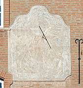 Sundial of 1906
 Music school Claude Nougaro
 Dovecote of Bouysset.
 War memorial
See also
Communes of the Haute-Garonne department
References
- ↑ Françoise Salomé and Michel Lépine, Labège au siècle des lumières, Broché, 1998.
| Wikimedia Commons has media related to Labège. |