Gros-Mécatina, Quebec
| Gros-Mécatina | |
|---|---|
| Municipality | |
 | |
 Location within Le Golfe-du-Saint-Laurent RCM. | |
 Gros-Mécatina Location in Côte-Nord Region of Quebec. | |
| Coordinates: 50°50′N 58°58′W / 50.833°N 58.967°WCoordinates: 50°50′N 58°58′W / 50.833°N 58.967°W[1] | |
| Country |
|
| Province |
|
| Region | Côte-Nord |
| RCM | Le Golfe-du-Saint-Laurent |
| Constituted | January 1, 1994 |
| Government[2] | |
| • Mayor | Randy Jones |
| • Federal riding | Manicouagan |
| • Prov. riding | Duplessis |
| Area[2][3] | |
| • Total | 1,388.20 km2 (535.99 sq mi) |
| • Land | 804.80 km2 (310.74 sq mi) |
| Highest elevation | 59 m (194 ft) |
| Lowest elevation | 0 m (0 ft) |
| Population (2016)[3] | |
| • Total | 367 |
| • Density | 0.6/km2 (2/sq mi) |
| • Pop 2006-2011 |
|
| • Dwellings | 270 |
| Time zone | AST (UTC-4) |
| Postal code(s) | G0G 1T0 |
| Area code(s) | 418 and 581 |
| Highways | No major routes |
| GNBC Code | EPSNX |
| NTS Map | 012J15 |
The Municipality of Gros-Mécatina is on the Lower North Shore of the Gulf of Saint Lawrence, near the border with Labrador in Quebec, Canada. Located near excellent crab, lobster, and scallop fishing grounds, it is dependent on the fishing business, including a fish processing factory that contributes to regional economic activity.[1][4]
The isolated municipality can only be reached via a regular weekly ferry service, or La Tabatière Airport. The villages of La Tabatière and Mutton Bay are connected via a 10 kilometres (6.2 mi) asphalted road that provides some spectacular views of the gulf from the mountains; but in the winter the road is not plowed, and the only access is via snowmobile.
The name, pronounced (me-kuh-TEE-nuh)is from the Innu word makatinau, or "It is a large mountain."[5]
History
Exploration of the area began in 1535 when Jacques Cartier passed by during his second voyage. The place became an important hunting and fishing ground in the first part of the 18th century. From 1739, Jean-Baptiste Pommereau acquired the fishing rights of the region for a period of ten years. The Gros-Mécatina Post, built in the same time period near present-day La Tabatière, quickly became one of the most important fishing settlements of the North Shore. Big Mécatina Island also, granted to Intendant Gilles Hocquart in 1755, was a popular location with fishermen. They remained such until at least 1808 when the authorities of Quebec sold Gros-Mécatina. By then permanent settlement had begun.[1]
The Municipality of Gros-Mécatina was formed on January 1, 1994, when its territory was separated from the Municipality of Côte-Nord-du-Golfe-Saint-Laurent. It was named after several geographic features within its area called Gros Mécatina, including a river, cape, island, archipelago, and lake. Mecatina comes from the Innu word makatinau, meaning "large mountain."[1]
Communities
The municipality consists of two small isolated fishing villages, La Tabatière and Mutton Bay, as well as the abandoned settlements of Lac-Salé and Baie-des-Ha!-Ha! (Baie de la Terre).
La Tabatière
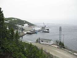
La Tabatière (50°49′45″N 58°57′38″W / 50.82917°N 58.96056°W) is located on La Tabatière Bay, opposite Big Mecatina Island (île du Gros Mécatina), and home to a fish processing plant and reservoirs to supply vessels that serve this part of the region. According to popular opinion, the origin of its name (French for "the snuff box") refers to the loss of a tobacco pouch by a missionary. However, it is a corruption of tabaquen, possibly Innu, which became tapatienne and then tabatière. Missionary correspondence shows that the parish was at one time often referred to as Saint-Joseph-de-Tabaquen, a name said to mean "sorcery," and a priest who visited the mission in 1887 wrote that aboriginal groups who came to trade would consult a "sorcerer-magician" before leaving for their camps in the interior forests to find out the prospects for their return trip.[6]
La Tabatière has long been frequented by fishermen and traders, particularly attractive for fishing cod and seals. In 1820, Scotsman Samuel Robertson, former employee of the Gros-Mécatina Post, settled there and founded a permanent settlement that his descendants still occupy today. In 1855, he was joined by settlers from Jersey and the place became known by the English name Sparr Point.[7] In 1885, the catholic mission Saint-Joseph-de-la-Tabatière was established and La Tabatière post office began operations on November 1, 1907.[6] In the 1930s, the seal oil rendering and fish oil factory burned down and was rebuilt as a fish-processing plant which today is the largest on the Coast.[8]
Mutton Bay
Mutton Bay (in French: Baie-des-Moutons 50°46′19″N 59°01′45″W / 50.77194°N 59.02917°W) is a small isolated fishing village on the namesake bay, just east of the mouth of the Big Mecatina River. The meaning of its name remains obscure since it seems unlikely that there ever were any sheep present. The name may be used as a metaphor for the white foam of waves, or for the hills that surround the bay, which are all rounded at the top.[9]
In 1804, notary Félix Têtu reported the establishment of the Baie-Moutons trading post. In the middle of the 19th century, the bay was being fished but the village was not really established until 1872 when Newfoundlanders arrived and settled there. By 1886, the local post office opened, first identified as Saint-Joseph-de-la-Tabatière, then from 1896 on as Mutton Bay. In 1983, the place name was officially anglized to Mutton Bay, replacing Baie-des-Moutons, because of the majority of English-speaking residents. By 1988, Mutton Bay had 55 families, living mainly from fishing lobster and scallops.[9]
Demographics
Population
| Canada census – Gros-Mécatina, Quebec community profile | |||
|---|---|---|---|
| 2011 | 2006 | 2001 | |
| Population: | 499 (-11.8% from 2006) | 566 (-1.2% from 2001) | 573 (-7.9% from 1996) |
| Land area: | 804.80 km2 (310.74 sq mi) | 804.80 km2 (310.74 sq mi) | 804.81 km2 (310.74 sq mi) |
| Population density: | 0.6/km2 (1.6/sq mi) | 0.7/km2 (1.8/sq mi) | 0.7/km2 (1.8/sq mi) |
| Median age: | 47.1 (M: 47.9, F: 46.0) | 43.4 (M: 43.8, F: 42.5) | 39.2 (M: 40.1, F: 37.8) |
| Total private dwellings: | 270 | 265 | 244 |
| Median household income: | $.N/A | $45,078 | $39,721 |
| Notes: 2011 income data for this area has been suppressed for data quality or confidentiality reasons. – References: 2011[3] 2006[10] 2001[11] | |||
| Historical Census Data - Gros-Mécatina, Quebec[12] | ||||||||||||||||||||||||||||||||||
|---|---|---|---|---|---|---|---|---|---|---|---|---|---|---|---|---|---|---|---|---|---|---|---|---|---|---|---|---|---|---|---|---|---|---|
|
|
|
|
| ||||||||||||||||||||||||||||||
Language
| Canada Census Mother Tongue - Gros-Mécatina, Quebec[12] | ||||||||||||||||||
|---|---|---|---|---|---|---|---|---|---|---|---|---|---|---|---|---|---|---|
| Census | Total | French |
English |
French & English |
Other | |||||||||||||
| Year | Responses | Count | Trend | Pop % | Count | Trend | Pop % | Count | Trend | Pop % | Count | Trend | Pop % | |||||
| 2011 |
495 |
25 | |
5.05% | 470 | |
94.95% | 0 | |
0.00% | 0 | |
0.00% | |||||
| 2006 |
575 |
25 | |
4.35% | 540 | |
93.91% | 10 | |
1.74% | 0 | |
0.00% | |||||
| 2001 |
575 |
35 | |
6.09% | 520 | |
90.43% | 20 | |
3.48% | 0 | |
0.00% | |||||
| 1996 |
625 |
30 | n/a | 4.80% | 585 | n/a | 93.60% | 10 | n/a | 1.60% | 0 | n/a | 0.00% | |||||
See also
References
- 1 2 3 4 "Gros-Mécatina (Municipalité)" (in French). Commission de toponymie du Québec. Retrieved 2010-09-22.
- 1 2 Ministère des Affaires municipales, des Régions et de l'Occupation du territoire - Répertoire des municipalités: Gros-Mécatina
- 1 2 3 "Gros-Mécatina census profile". 2011 Census of Population. Statistics Canada. 2007-03-13. Retrieved 2010-09-22.
- ↑ "Discover the region > Our villages > Mutton Bay". Tourism Lower North Shore. Retrieved 2010-09-22.
- ↑ http://www.innu-aimun.ca/dictionary/Words
- 1 2 "La Tabatière (village)" (in French). Commission de toponymie du Québec. Retrieved 2010-09-22.
- ↑ Townsend, Charles W. “In Audubon's Labrador.” The Auk, vol. 34, no. 2, 1917, pp. 142. http://www.jstor.org/stable/4072478.
- ↑ "Discover the region > Our villages > La Tabatière". Tourism Lower North Shore. Retrieved 2010-09-22.
- 1 2 "Mutton Bay (village)" (in French). Commission de toponymie du Québec. Retrieved 2010-09-22.
- ↑ "2006 Community Profiles". Canada 2006 Census. Statistics Canada. March 30, 2011. Retrieved 2014-02-09.
- ↑ "2001 Community Profiles". Canada 2001 Census. Statistics Canada. February 17, 2012. Retrieved 2014-02-09.
- 1 2 Statistics Canada: 1996, 2001, 2006, 2011 census
External links
 |
Petit-Mécatina | Saint-Augustin | | |
| |
||||
| ||||
| | ||||
| Côte-Nord-du-Golfe-du-St-Laurent | Gulf of Saint Lawrence |
| Municipalities | |
|---|---|
| Unorganized Territories | |
| Native reserves (Unassociated with RCM) | |
| |