La Rochette, Ardèche
| La Rochette | |
|---|---|
|
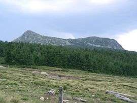
Mont Mézenc seen from La Rochette | |
 La Rochette | |
|
Location within Auvergne-Rhône-Alpes region  La Rochette | |
| Coordinates: 44°55′01″N 4°14′30″E / 44.9169°N 4.2417°ECoordinates: 44°55′01″N 4°14′30″E / 44.9169°N 4.2417°E | |
| Country | France |
| Region | Auvergne-Rhône-Alpes |
| Department | Ardèche |
| Arrondissement | Tournon-sur-Rhône |
| Canton | Saint-Martin-de-Valamas |
| Government | |
| • Mayor (2008–2014) | Serge Charpenay |
| Area1 | 13.86 km2 (5.35 sq mi) |
| Population (2008)2 | 60 |
| • Density | 4.3/km2 (11/sq mi) |
| Time zone | CET (UTC+1) |
| • Summer (DST) | CEST (UTC+2) |
| INSEE/Postal code | 07195 / 07310 |
| Elevation |
787–1,726 m (2,582–5,663 ft) (avg. 930 m or 3,050 ft) |
|
1 French Land Register data, which excludes lakes, ponds, glaciers > 1 km² (0.386 sq mi or 247 acres) and river estuaries. 2 Population without double counting: residents of multiple communes (e.g., students and military personnel) only counted once. | |
La Rochette is a commune in the Ardèche department in southern France.
Population
| Historical population | ||
|---|---|---|
| Year | Pop. | ±% |
| 1962 | 100 | — |
| 1968 | 169 | +69.0% |
| 1975 | 124 | −26.6% |
| 1982 | 110 | −11.3% |
| 1990 | 64 | −41.8% |
| 1999 | 57 | −10.9% |
| 2008 | 60 | +5.3% |
See also
References
| Wikimedia Commons has media related to La Rochette, Ardèche. |
This article is issued from Wikipedia - version of the 10/28/2016. The text is available under the Creative Commons Attribution/Share Alike but additional terms may apply for the media files.