La Roche-sur-le-Buis
| La Roche-sur-le-Buis | |
|---|---|
 La Roche-sur-le-Buis | |
|
Location within Auvergne-Rhône-Alpes region  La Roche-sur-le-Buis | |
| Coordinates: 44°16′40″N 5°18′46″E / 44.2778°N 5.3128°ECoordinates: 44°16′40″N 5°18′46″E / 44.2778°N 5.3128°E | |
| Country | France |
| Region | Auvergne-Rhône-Alpes |
| Department | Drôme |
| Arrondissement | Nyons |
| Canton | Buis-les-Baronnies |
| Intercommunality | Pays du Buis-les-Baronnies |
| Government | |
| • Mayor (2008–2014) | Michel Grégoire |
| Area1 | 27.72 km2 (10.70 sq mi) |
| Population (2008)2 | 330 |
| • Density | 12/km2 (31/sq mi) |
| Time zone | CET (UTC+1) |
| • Summer (DST) | CEST (UTC+2) |
| INSEE/Postal code | 26278 / 26170 |
| Elevation |
394–1,369 m (1,293–4,491 ft) (avg. 638 m or 2,093 ft) |
|
1 French Land Register data, which excludes lakes, ponds, glaciers > 1 km² (0.386 sq mi or 247 acres) and river estuaries. 2 Population without double counting: residents of multiple communes (e.g., students and military personnel) only counted once. | |
La Roche-sur-le-Buis is a commune in the Drôme department in southeastern France.
Population
| Historical population | ||
|---|---|---|
| Year | Pop. | ±% |
| 1911 | 412 | — |
| 1962 | 113 | −72.6% |
| 1968 | 134 | +18.6% |
| 1975 | 147 | +9.7% |
| 1982 | 196 | +33.3% |
| 1990 | 211 | +7.7% |
| 1999 | 287 | +36.0% |
| 2008 | 330 | +15.0% |
See also
References
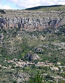
La Roche-sur-le-Buis, overview.
| Wikimedia Commons has media related to La Roche-sur-le-Buis. |
This article is issued from Wikipedia - version of the 10/28/2016. The text is available under the Creative Commons Attribution/Share Alike but additional terms may apply for the media files.