La Loche
| La Loche | |
|---|---|
| Northern village[1] | |
|
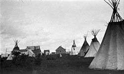
The 1918 summer gathering in La Loche | |
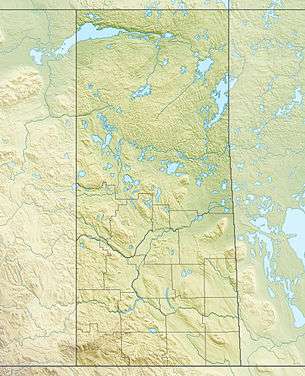 La Loche  La Loche Location of La Loche in Saskatchewan | |
| Coordinates: 56°29′N 109°26′W / 56.483°N 109.433°W | |
| Country |
|
| Province |
|
| Census division | 18 |
| HBC post | 1810 |
| Mission founded | 1860 |
| Post office established | 1926 |
| Government | |
| • Mayor | Robert St. Pierre |
| • Town Manager | Janine Boucher |
| • Governing body | La Loche Town Council |
| • MLA Athabasca | Buckley Belanger |
| • MP Desnethé—Missinippi—Churchill River | Georgina Jolibois |
| Area | |
| • Total | 15.59 km2 (6.02 sq mi) |
| Population (2011)[2] | |
| • Total | 2,607 |
| • Density | 167.5/km2 (434/sq mi) |
| Time zone | Central Standard Time (UTC−6) |
| Postal code | S0M 1G0 |
| Area code(s) | 306 |
| Highways |
|
| [3][4][5] | |
La Loche is a village in northwest Saskatchewan. It is located at the end of Highway 155 on the eastern shore of Lac La Loche in Canada's boreal forest. La Loche had a population of 2,611 in 2011 and is within the Northern Saskatchewan Administration District.[2][6][7]
Bordering La Loche to the north and reached via Highway 955 is the Clearwater River Dene Nation (CRDN) with a population of 778 people.[2] The La Loche/CRDN population centre with 3,389 people represents about 30 percent of the Denesuline speakers of Canada. The Denesuline language is spoken by 89% of the residents.[8]
The northern hamlet of Black Point lies on the southern shore of the lake and is accessible via the Garson Lake Road Highway 956. This road ends in Garson Lake. From there a winter road is built every year to Fort McMurray, Alberta.
Located on the northern end of Lac La Loche is the Methye Portage or Portage La Loche. This portage to the Clearwater River was in use for more than a century during the North American fur trade. Brigades such as the Portage La Loche Brigade from Fort Garry came from the south while the Athabasca and Mackenzie brigades came from the north. At Rendezvous Lake on the 19 kilometre portage the fur brigades would meet every year and exchange trade goods for furs. The furs were then brought to York Factory on the Hudson Bay for shipment to England. The Methye Portage is now part of the Clearwater River Provincial Park and a National Historic Site.[9] The Clearwater River is also a Canadian Heritage River.
History


.jpg)
Fur trade posts were built on Lac La Loche soon after Peter Pond came through the Methye Portage in 1778.[10] The Atlas of Canada [11] shows four posts of the North West Company beginning in 1780 to 1819 and three posts of the Hudson's Bay Company beginning in 1819.
Another map by the archaeologist Don Steer in 1972[12] shows the locations and the dates of seven of these posts. North West Company posts were located on the large peninsula called 'Big Point' (circa 1789-91) and on the south west side of the lake (1819–21). A Hudson's Bay post was located at the mouth of the portage in 1810. Transportation depots were located at each end of the portage from the 1820s to 1880s. In 1857 a permanent trading post was built on the south end of the Portage. This post moved to nearby West La Loche in the 1870s until it was destroyed by fire in 1936. The HBC relocated their post across the lake at La Loche in the newly purchased Revillon Frères buildings where they remained until they sold their northern stores in 1987. The Revillon Frères post had been in La Loche since 1906.[13]
Missionary priests have been coming to La Loche since 1845. In 1860 the separate La Loche Mission of Notre Dame de la Visitation was established. Father Jean-Marie Pénard O.M.I. (the first resident priest of La Loche from 1895 to 1917) wrote in 1895 that the population of La Loche at the Mission was around 100 people and the population at the fort in West La Loche (six miles from the Portage) was 60 to 70 people.[14] In 1911 he wrote that La Loche had 200 people with another 80 to 100 people living in two communities across the lake.[15] He added that during the autumn of 1911 most residents left for winter camps to the north to hunt leaving only 60 or 70 people around the lake.
In 1922 Father Jean-Baptiste Ducharme O.M.I. wrote that there were 500 people in the La Loche Mission area.[16] The Mission included other communities such as Bull's House (at the end of the La Loche River), Turnor Lake, Descharme Lake and Garson Lake.
In the 1940s a convent was built for the Grey Nuns (now a private residence) along with the first hospital and the first school of the community. In 1953 a new Roman Catholic Mission church which is still in use was constructed.
The first road (Highway 155) reached La Loche in 1963. Water/sewer and electricity became available to most homes in 1974. Direct dial telephone came in 1974, television in 1976 and a skating arena in 1978. In 1979 a new high school was opened, Highway 955 to the Cluff Lake uranium mine site was completed and the Clearwater River Dene Nation was officially created.
Early settlement
.jpg)
In 1820 George Back while travelling through with Franklin's Coppermine Expedition of 1819–1822 stopped at Lac La Loche House (the HBC trading post). He described this post as "logs piled one above the other with mud and moss to fill up the crevices - there is a single partition which divides the Master's room from that of the men. - the former has half a roof to it - some parchment windows make up the whole - ". The NWC Post, he wrote was "a square and flat roofed hut just seven feet high - neither wind nor weather tight in which are stowed - Master, men, women, children, dogs and sledges - ".
Back provides an early indication of settlement on Lac La Loche when on his return journey in 1822 he wrote in his journal: "We touched at the houses on the borders of the lake and embarked a man in each canoe".[17]
2016 shootings
On January 22, 2016, four people were killed and seven others injured in a shooting spree in La Loche. Two people, said to be the suspect's cousins, were killed at their home, and two teachers were killed at La Loche Community School.[18][19][20][21][22] A 17-year-old male suspect was apprehended and taken into custody.[23][24]

Demographics
| Historical populations | ||
|---|---|---|
| Year | Pop. | ±% |
| 1906 | 216 | — |
| 1986 | 1,623 | +651.4% |
| 1991 | 1,691 | +4.2% |
| 1996 | 1,966 | +16.3% |
| 2001 | 2,136 | +8.6% |
| 2006 | 2,348 | +9.9% |
| 2011 | 2,611 | +11.2% |
| [25][26][27] | ||
| Canada census – La Loche community profile | |||
|---|---|---|---|
| 2011 | 2006 | 2001 | |
| Population: | 2,611 (+11.2% from 2006) | 2,348 (9.9% from 2001) | 2,136 (+8.6% from 1996) |
| Land area: | 15.59 km2 (6.02 sq mi) | 15.59 km2 (6.02 sq mi) | 15.59 km2 (6.02 sq mi) |
| Population density: | 167.5/km2 (434/sq mi) | 150.6/km2 (390/sq mi) | 137.0/km2 (355/sq mi) |
| Median age: | 22.6 (M: 21.6, F: 23.4) | 20.5 (M: 19.0, F: 22.15) | 18.1 (M: 16.8, F: 19.9) |
| Total private dwellings: | 700 | 662 | 577 |
| Median household income: | $36,011 | ||
| References: 2011[28] 2006[29] 2001[30] | |||
The La Loche Population Centre has a population of 3,389 in two adjoining communities. These two communities and their 2011 Canada Census population are: La Loche (northern village) with 2,611 residents and the Clearwater River Dene Nation with 778 residents.[2]
In 2006 there were 590 registered members of the Clearwater River Dene Nation and other First Nations living in La Loche.[31] In 2011 there were 680 registered members.[32]


| Aboriginal population, 2011 | ||
|---|---|---|
| [33] | Population | Percent |
| Métis | 1,785 | 68% |
| First Nations | 740 | 28.2% |
| Non-Aboriginal identity | 90 | 3.4% |
| Total respondent population | 2625 | 100% |
| Non-official languages spoken, 2011 | ||
|---|---|---|
| [33] | Population | Percent |
| Dene | 2,420 | 99.2% |
| Cree | 10 | 0.4% |
| Non-Aboriginal languages | 20 | 0.8% |
| Total respondent population | 2440 | 100% |
| La Loche population by religion, 2011 | ||
|---|---|---|
| [33] | Population | Percent |
| Total Christian | 2,565 | 97.5% |
| Catholic | 2,525 | 96% |
| Other Christian | 50 | 1.9% |
| Other religions | 0 | 0% |
| No religious affiliation | 60 | 2.3% |
| Total respondent population | 2630 | 100% |
Recreation

The La Loche Arena Complex houses the Robbie Fontaine Memorial Arena, a meeting hall, the local radio station CHPN-FM, activity rooms and offices.
The Dave O'Hara Public Library at Ducharme School offers internet access.

The La Loche Friendship Centre and the La Loche Sport, Recreation and Culture Board organize many of the activities and festivals that occur every year and are working together on the development of a community recreation area which now offers a skateboard park, a children's playground and an outdoor skating rink.
The week long "Yanessa Days Festival", the "La Loche Long Sun Run" and the Canada Day celebrations are a few of the popular yearly events.
Churches
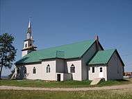
Our Lady of the Visitation Roman Catholic Church has regular services (10:30 a.m. on Sundays) and is part of the Archdiocese of Keewatin-Le Pas.[34]
Clearwater River Ministries offers Sunday services and gospel studies.
Education

La Loche Community School consists of two buildings (The Ducharme Building and the Dene Building). The Ducharme Building offers the Pre-K to 6 program while the Dene Building delivers the 7 to 12 program. The school has an enrollment of over 900 students. The school is a provincial school and is part of Northern Lights School Division #113. The first school of La Loche was built in 1941 and was called the Community Day School. In 1942 it had an enrollment of 23.
Clearwater River Dene School at Clearwater River is a K-12 school with an enrollment of 200.
The Gabriel Dumont Institute offers adult basic education and skills training.
Infrastructure
La Loche has an active business community that serves the growing population and the mining companies exploring north of the community.
Air services are provided by the La Loche Airport and the La Loche Water Aerodrome. The Saskatchewan Transportation Company (STC) offers bus service from Prince Albert for passengers and freight.[35] The Canada Post office receives mail five times a week.
The La Loche detachment of the RCMP and the La Loche Volunteer Fire Department serve La Loche and nearby communities.
Utilities
The Northern Village of La Loche provides water and sewer service, garbage pick-up, road maintenance, snow removal and through CHPN Communications local radio and cable television services (over 40 channels are available). SaskPower provides electricity and SaskTel provides telephone, 911 emergency service and internet services (including high speed service). Methy Construction and Maintenance Corporation owned by the northern village offers commercial and residential property development and construction and contracting for heavy equipment.[36]
Health care

The La Loche Hospital serves a regional population of over 4,000 people and is part of the Keewatin Yatthé Regional Health Authority. Ambulance services are available as is a 911 call service for emergencies. A pharmacy is centrally located.
The Armand Bekkattla Treatment Centre is located at the Clearwater River Dene Nation.
See also
References
- ↑ "Search for Municipal Information". Government of Saskatchewan. Retrieved April 7, 2014.
- 1 2 3 4 "2011 Community Profiles". Statistics Canada. Government of Canada. Retrieved May 29, 2012.
- ↑ National Archives, Archivia Net. "Post Offices and Postmasters". Retrieved 2009-09-06.
- ↑ Government of Saskatchewan, MRD Home. "Municipal Directory System". Retrieved 2012-10-16.
- ↑ Commissioner of Canada Elections, Chief Electoral Officer of Canada (2005). "Elections Canada On-line". Retrieved 2009-09-06.
- ↑ "Types of Municipalities". Saskatchewan Ministry of Municipal Affairs. Retrieved December 19, 2013.
- ↑ "La Loche: Canada, full name, administrative division, geographic coordinates and map". Geographic.org. Retrieved January 23, 2016.
- ↑ "History of La Loche (La Loche 2011)". 2012-11-15.
- ↑ "Parks Canada (Methye Portage National Historic Event)". Retrieved 2012-10-12.
- ↑ "ENCYCLOPEDIA OF SASKATCHEWAN (list of forts in Northern Saskatchewan)". Retrieved 2012-10-12.
- ↑ "Natural Resources Canada (The Atlas of Canada)". Retrieved 2012-10-12.
- ↑ "Our Legacy (Map of Methye Portage Region)". Retrieved 2012-10-12.
- ↑ "History of La Loche (Timeline)". Retrieved 2012-10-10.
- ↑ "Peel's Prairie Provinces (Peel 7848)". 2012-10-10.
- ↑ "Peel's Prairie Provinces (Peel 8059)". 2012-10-10.
- ↑ "Peel's Prairie Provinces (Peel 8173)". 2012-10-10.
- ↑ Houston, Stuart (1994-10-25). Arctic Artist: The Journal and Paintings of George Back, Midshipman with Franklin, 1819-1822. McGill-Queens. p. 207.
- ↑ Gordon, Julie; Nickel, Rod (January 23, 2016). "Remote Canadian community reels from shootings". Duluth News Tribune. Reuters. Retrieved January 23, 2016.
- ↑ Tait, Carrie (January 24, 2016). "Accused in La Loche shooting is related to two victims". The Globe and Mail. Retrieved January 24, 2016.
- ↑ Warick, Jason (January 23, 2016). "'Right now, La Loche is devastated:' Saskatchewan school shooting leaves four dead". calgarysun.com. Calgary Sun. Retrieved January 23, 2016.
- ↑ "Canada school shooting: Five killed in Saskatchewan". bbc.com. BBC. January 22, 2016. Retrieved January 22, 2016.
- ↑ "La Loche, Sask., shooting death toll left 4 dead, RCMP say". cbc.ca. CBC. January 22, 2016. Retrieved January 22, 2016.
- ↑ Warick, Jason (January 23, 2016). "'They were my best friends'; Grandfather of slain La Loche boys mourns (w/ video)". The Star Phoenix. Retrieved January 23, 2016.
- ↑ Martinez, Michael; Ellis, Ralph (January 22, 2016). "Four dead, several injured in shooting in Saskatchewan school". cnn.com. CNN. Retrieved January 22, 2016.
- ↑ "1996 Community Profiles". Statistics Canada. Government of Canada. Retrieved 2015-05-23.
- ↑ "Census of Manitoba, Saskatchewan and Alberta, 1906 (Province of Saskatchewan District 17, Sub-district No.1 (pages 16 to 19))". Statistics Canada. Government of Canada. Retrieved 2015-05-23. line feed character in
|title=at position 20 (help) - ↑ "Saskatchewan Census Population (Northern Hamlets and villages)" (PDF). Retrieved 12 July 2015.
- ↑ "2011 Community Profiles". Canada 2011 Census. Statistics Canada. July 5, 2013. Retrieved 2012-05-30.
- ↑ "2006 Community Profiles". Canada 2006 Census. Statistics Canada. March 30, 2011. Retrieved 2009-02-24.
- ↑ "2001 Community Profiles". Canada 2001 Census. Statistics Canada. February 17, 2012. Retrieved 2012-05-30.
- ↑ "2006 Aboriginal Population Profile (La Loche)". Retrieved 2014-05-11.
- ↑ "2011 Aboriginal Population Profile (La Loche)". Retrieved 2014-06-14.
- 1 2 3 "NHS Profile, La Loche, NV, Saskatchewan, 2011 (The sum of the ancestries in this table is greater than the total population estimate because a person may report more than one ancestry (ethnic origin) in the National Household Survey.)". 2011. Retrieved 2014-09-14.
- ↑ Adamson, Julia (16 February 2013). "Saskatchewan Roman Catholic Churches ~ Online Parish Registers ~ History". Saskatchewan Gen Web. Ancestry.com. Retrieved 2013-02-13.
- ↑ Saskatchewan Transportation Company. "Route Map" (PDF). Retrieved 2014-07-18.
- ↑ Saskatchewan Ministry of the Economy. "Methy Construction and Maintenance Corporation". Retrieved 2014-07-18.
External links
| Wikimedia Commons has media related to La Loche, Saskatchewan. |
- Map of La Loche at Statcan
- Community Profile for "La Loche, Saskatchewan", Statistics Canada
- Saskatchewan GenWeb
- Clearwater River Provincial Park
- Encyclopedia of Saskatchewan
- Google Interactive Map (La Loche Locations)
Coordinates: 56°29′N 109°26′W / 56.483°N 109.433°W
 |
Cluff Lake mine | | ||
| Fort McMurray | |
La Ronge | ||
| ||||
| | ||||
| Buffalo Narrows |