La Forêt-de-Tessé
| La Forêt-de-Tessé | |
|---|---|
|
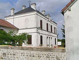
Town hall | |
 La Forêt-de-Tessé | |
|
Location within Nouvelle-Aquitaine region  La Forêt-de-Tessé | |
| Coordinates: 46°04′52″N 0°05′06″E / 46.0811°N 0.085°ECoordinates: 46°04′52″N 0°05′06″E / 46.0811°N 0.085°E | |
| Country | France |
| Region | Nouvelle-Aquitaine |
| Department | Charente |
| Arrondissement | Confolens |
| Canton | Villefagnan |
| Intercommunality | Pays de Villefagnan |
| Government | |
| • Mayor (2008–2014) | Dominique Ravaud |
| Area1 | 10.70 km2 (4.13 sq mi) |
| Population (2008)2 | 205 |
| • Density | 19/km2 (50/sq mi) |
| Time zone | CET (UTC+1) |
| • Summer (DST) | CEST (UTC+2) |
| INSEE/Postal code | 16142 / 16240 |
| Elevation |
120–158 m (394–518 ft) (avg. 143 m or 469 ft) |
|
1 French Land Register data, which excludes lakes, ponds, glaciers > 1 km² (0.386 sq mi or 247 acres) and river estuaries. 2 Population without double counting: residents of multiple communes (e.g., students and military personnel) only counted once. | |
La Forêt-de-Tessé commune in the Charente department in southwestern France.
Population
| Historical population | ||
|---|---|---|
| Year | Pop. | ±% |
| 1793 | 772 | — |
| 1800 | 716 | −7.3% |
| 1806 | 819 | +14.4% |
| 1821 | 911 | +11.2% |
| 1831 | 904 | −0.8% |
| 1841 | 904 | +0.0% |
| 1846 | 860 | −4.9% |
| 1851 | 853 | −0.8% |
| 1856 | 808 | −5.3% |
| 1861 | 713 | −11.8% |
| 1866 | 705 | −1.1% |
| 1872 | 639 | −9.4% |
| 1876 | 646 | +1.1% |
| 1881 | 663 | +2.6% |
| 1886 | 629 | −5.1% |
| 1891 | 624 | −0.8% |
| 1896 | 584 | −6.4% |
| 1901 | 554 | −5.1% |
| 1906 | 553 | −0.2% |
| 1911 | 517 | −6.5% |
| 1921 | 458 | −11.4% |
| 1926 | 438 | −4.4% |
| 1931 | 421 | −3.9% |
| 1936 | 405 | −3.8% |
| 1946 | 396 | −2.2% |
| 1954 | 395 | −0.3% |
| 1962 | 339 | −14.2% |
| 1968 | 284 | −16.2% |
| 1975 | 249 | −12.3% |
| 1982 | 222 | −10.8% |
| 1990 | 212 | −4.5% |
| 1999 | 195 | −8.0% |
| 2008 | 205 | +5.1% |
See also
References
| Wikimedia Commons has media related to La Forêt-de-Tessé. |
This article is issued from Wikipedia - version of the 2/12/2016. The text is available under the Creative Commons Attribution/Share Alike but additional terms may apply for the media files.