La Aguada y Costa Azul
| La Aguada y Costa Azul | |
|---|---|
| Village | |
 La Aguada y Costa Azul Location in Uruguay | |
| Coordinates: 34°38′0″S 54°9′0″W / 34.63333°S 54.15000°WCoordinates: 34°38′0″S 54°9′0″W / 34.63333°S 54.15000°W | |
| Country |
|
| Department | Rocha Department |
| Population (2011) | |
| • Total | 1,090 |
| Time zone | UTC -3 |
| Postal code | 27002 |
| Dial plan | +598 4479 (+4 digits) |
| Climate | Cfb |
La Aguada y Costa Azul is a village in the Rocha Department of southeastern Uruguay.
Location
The village is located on the Atlantic and shares borders with La Paloma to the south the border being the railroad track Rocha - La Paloma, and Arachania to the north.
History
Its status was elevated to "Pueblo" (village) on 21 December 1995 by the Act of Ley Nº 12.253.[1]
Population
In 2011 La Aguada y Costa Azul had a population of 1,090.[2]
| Year | Population |
|---|---|
| 1963 | 210 |
| 1975 | 454 |
| 1985 | 967 |
| 1996 | 1,125 |
| 2004 | 1,103 |
| 2011 | 1,090 |
Source: Instituto Nacional de Estadística de Uruguay[3]
References
- ↑ "LEY N° 12.253". República Oriental del Uruguay, Poder Legislativo. 1995. Retrieved 1 July 2011.
- ↑ "Censos 2011 Cuadros Rocha". INE. 2012. Retrieved 25 August 2012.
- ↑ "Statistics of urban localities (1963–2004)" (PDF). INE. 2012. Retrieved 5 September 2012.
External links
| Resorts and Landforms |
|
|---|---|
| |
Capital: Rocha | ||
| Towns and villages | 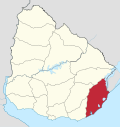 | |
| Sights |
| |
This article is issued from Wikipedia - version of the 8/29/2015. The text is available under the Creative Commons Attribution/Share Alike but additional terms may apply for the media files.