Kylling Bridge
| Kylling Bridge | |
|---|---|
 | |
| Coordinates | 62°20′17″N 8°3′39″E / 62.33806°N 8.06083°ECoordinates: 62°20′17″N 8°3′39″E / 62.33806°N 8.06083°E |
| Carries | Rauma Line |
| Crosses | Rauma |
| Locale | Verma |
| Official name | Kylling bru |
| Maintained by | Norwegian National Rail Administration |
| Characteristics | |
| Total length | 76 m (249 ft) |
| Longest span | 42 m (138 ft) |
| Clearance below | 59.3 m (195 ft) |
| History | |
| Construction end | 1921 |
| Opened | 29 November 1924 |
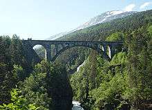
Kylling Bridge (Norwegian: Kylling bru) is a railway bridge in Rauma Municipality in Møre og Romsdal county, Norway. The bridge crosses the Rauma River near the village of Verma in the upper part of the Romsdalen valley. The bridge is part of a double horseshoe curve that allows the railway to pass a narrow and steep section of the valley.[1] It is one of the most photographed railway bridges in Norway. Kylling Bridge is 76 metres (249 ft) long. The main span is 42 metres (138 ft), and side spans are 10 metres (33 ft) and 8 metres (26 ft). The clearance to the river below is 59.3 metres (195 ft).[2]
The building of Kylling Bridge started in September 1913. After almost 9 years, the bridge was finally finished in the winter of 1921. The Rauma Line railway opened on 29 November 1924. Kylling Bridge cost NOK 676,000.[3]
References
- ↑ Raumabana (in Norwegian). Rauma kulturstyre. 1994. ISBN 82-91317-01-1.
- ↑ Store norske leksikon. "Kylling bru" (in Norwegian). Retrieved 2010-10-27.
- ↑ "Kyllingbrua" (in Norwegian). Retrieved 2010-10-27.