Kyauktaga Township
For the township in Yangon (Rangoon), see Kyauktada Township.
| Kyauktaga Township ကျောက်တံတား မြို့နယ် Kyaukdaga Township | |
|---|---|
| Township | |
| Coordinates: 18°11′N 96°21′E / 18.183°N 96.350°ECoordinates: 18°11′N 96°21′E / 18.183°N 96.350°E | |
| Country |
|
| Region | Bago Region |
| District | Taungoo District |
| Capital | Kyauktaga |
| Area | |
| • Total | 2,831 km2 (1,093 sq mi) |
| Time zone | MST (UTC+6.30) |
Kyauktaga Township is a township in Taungoo District in the Bago Region of Burma (Myanmar).[1] The principal town is Kyauktaga, and Penwegon is the other major town.[2] Both are located on the Bago–Taungoo highway and rail line.[3]
Communities
Kyauktaga Township is subdivided into 13 wards and 47 Village Tracts which consist of 283 villages.
Notes
- ↑ Township 31, "Myanmar States/Divisions & Townships Overview Map" Myanmar Information Management Unit (MIMU)
- ↑ "Pènwègon, Bago, Myanmar [Burma, populated place N 18° 13' 0 E 96° 34' 0"] GeoNames.org
- ↑ "Bago Division (East)" map, creation date 8 July 2009, Myanmar Information Management Unit (MIMU)
External links
- "Kyauktaga Google Satellite Map" Maplandia World Gazetteer
- "Kyaukdaga Township" at MRTV3
Capital: | |
|
Capital: Bago | ||||||||
| East Bago Region |  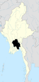 | |||||||
| West Bago Region | ||||||||
| Main cities and towns |
| |||||||
This article is issued from Wikipedia - version of the 1/7/2011. The text is available under the Creative Commons Attribution/Share Alike but additional terms may apply for the media files.