Kuttawa, Kentucky
| Kuttawa, Kentucky | |
|---|---|
| City | |
|
Kuttawa in 1939 | |
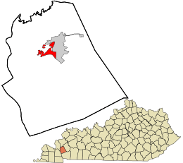 Location in Lyon County and the state of Kentucky. | |
| Coordinates: 37°3′32″N 88°6′49″W / 37.05889°N 88.11361°WCoordinates: 37°3′32″N 88°6′49″W / 37.05889°N 88.11361°W | |
| Country | United States |
| State | Kentucky |
| County | Lyon |
| Incorporated | 1872 |
| Named for | a Cherokee village |
| Area | |
| • Total | 2.6 sq mi (6.8 km2) |
| • Land | 1.9 sq mi (5.0 km2) |
| • Water | 0.7 sq mi (1.8 km2) |
| Elevation | 449 ft (137 m) |
| Population (2010) | |
| • Total | 649 |
| • Density | 307.1/sq mi (118.6/km2) |
| Time zone | Central (CST) (UTC-6) |
| • Summer (DST) | CDT (UTC-5) |
| ZIP code | 42055 |
| Area code(s) | 270 |
| FIPS code | 21-43264 |
| GNIS feature ID | 0495877 |

Kuttawa local /kəˈtɑːwə/[1] is a 5th-class city in Lyon County, Kentucky, in the United States. The population was 649 as of the 2010 U.S. census, up from 596 in 2000.
History
Former Ohio governor Charles Anderson founded the town on land he purchased in 1866. Originally spelled Cuttawa and Kittawa, Kuttawa seems to have been the name of a Cherokee village near the site, whose meaning is a matter of dispute: it has been variously translated as "beautiful", "city in the woods", and "great wilderness".[1] The city was formally incorporated by the state assembly in 1872,[2] the same year it received its post office.[1]
In the early 1960s, the Tennessee Valley Authority constructed a dam across the Cumberland River at Grand Rivers, forming Lake Barkley. Eddyville and Kuttawa were both moved from their original locations owing to the impounded lake.
Geography
Kuttawa is located at 37°3′32″N 88°6′49″W / 37.05889°N 88.11361°W (37.058964, -88.113643).[3]
According to the United States Census Bureau, the city has a total area of 2.6 square miles (6.7 km2), of which 1.9 square miles (4.9 km2) is land and 0.7 square miles (1.8 km2) (25.95%) is water.
Demographics
| Historical population | |||
|---|---|---|---|
| Census | Pop. | %± | |
| 1880 | 294 | — | |
| 1890 | 587 | 99.7% | |
| 1900 | 858 | 46.2% | |
| 1910 | 889 | 3.6% | |
| 1920 | 850 | −4.4% | |
| 1930 | 883 | 3.9% | |
| 1940 | 1,125 | 27.4% | |
| 1950 | 794 | −29.4% | |
| 1960 | 635 | −20.0% | |
| 1970 | 453 | −28.7% | |
| 1980 | 560 | 23.6% | |
| 1990 | 535 | −4.5% | |
| 2000 | 596 | 11.4% | |
| 2010 | 649 | 8.9% | |
| Est. 2015 | 661 | [4] | 1.8% |
As of the census[6] of 2000, there were 596 people, 220 households, and 157 families residing in the city. The population density was 307.1 people per square mile (118.6/km²). There were 317 housing units at an average density of 163.3 per square mile (63.1/km²). The racial makeup of the city was 96.14% White, 2.52% African American, 0.84% Native American, and 0.50% from two or more races.
There were 220 households, of which 24.1% had children under the age of 18 living with them, 62.7% were married couples living together, 5.5% had a female householder with no husband present, and 28.2% were non-families. 26.4% of all households were made up of individuals and 14.1% had someone living alone who was 65 years of age or older. The average household size was 2.20 and the average family size was 2.61.
In the city the population was spread out with 14.1% under the age of 18, 4.5% from 18 to 24, 18.3% from 25 to 44, 26.2% from 45 to 64, and 36.9% who were 65 years of age or older. The median age was 55 years. For every 100 females there were 70.8 males. For every 100 females age 18 and over, there were 68.4 males.
The median income for a household in the city was $45,357, and the median income for a family was $55,208. Males had a median income of $48,571 versus $31,375 for females. The per capita income for the city was $21,355. About 5.6% of families and 7.7% of the population were below the poverty line, including 11.9% of those under age 18 and 7.0% of those age 65 or over.
Climate
The climate in this area is characterized by hot, humid summers and generally mild to cool winters. According to the Köppen Climate Classification system, Kuttawa has a humid subtropical climate, abbreviated "Cfa" on climate maps.[7]
References
- 1 2 3 Rennick, Robert. Kentucky Place Names, p. 163. University Press of Kentucky (Lexington), 1987. Accessed 1 Aug 2013.
- ↑ Commonwealth of Kentucky. Office of the Secretary of State. Land Office. "Kuttawa, Kentucky". Accessed 1 Aug 2013.
- ↑ "US Gazetteer files: 2010, 2000, and 1990". United States Census Bureau. 2011-02-12. Retrieved 2011-04-23.
- ↑ "Annual Estimates of the Resident Population for Incorporated Places: April 1, 2010 to July 1, 2015". Retrieved July 2, 2016.
- ↑ "Census of Population and Housing". Census.gov. Retrieved June 4, 2015.
- ↑ "American FactFinder". United States Census Bureau. Retrieved 2008-01-31.
- ↑ "Kuttawa, Kentucky Köppen Climate Classification (Weatherbase)". Weatherbase.
External links
Municipalities and communities of Lyon County, Kentucky, United States | ||
|---|---|---|
| Cities | 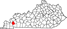 | |
| Unincorporated communities |
| |