Kutno County
| Kutno County Powiat kutnowski | |||
|---|---|---|---|
| County | |||
| |||
 Location within the voivodeship | |||
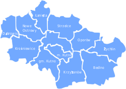 Division into gminas | |||
| Coordinates (Kutno): 52°14′N 19°22′E / 52.233°N 19.367°ECoordinates: 52°14′N 19°22′E / 52.233°N 19.367°E | |||
| Country |
| ||
| Voivodeship | Łódź | ||
| Seat | Kutno | ||
| Gminas | |||
| Area | |||
| • Total | 886.29 km2 (342.20 sq mi) | ||
| Population (2006) | |||
| • Total | 104,124 | ||
| • Density | 120/km2 (300/sq mi) | ||
| • Urban | 61,084 | ||
| • Rural | 43,040 | ||
| Car plates | EKU | ||
| Website | http://www.kutno.pl | ||

Kutno County (Polish: powiat kutnowski) is a unit of territorial administration and local government (powiat) in Łódź Voivodeship, central Poland. It came into being on January 1, 1999, as a result of the Polish local government reforms passed in 1998. Its administrative seat and largest town is Kutno, which lies 51 kilometres (32 mi) north of the regional capital Łódź. The county also contains the towns of Żychlin, lying 18 km (11 mi) east of Kutno, and Krośniewice, 14 km (9 mi) west of Kutno.
The county covers an area of 886.29 square kilometres (342.2 sq mi). As of 2006 its total population is 104,124, out of which the population of Kutno is 47,557, that of Żychlin is 8,880, that of Krośniewice is 4,647, and the rural population is 43,040.
Neighbouring counties
Kutno County is bordered by Włocławek County and Gostynin County to the north, Łowicz County to the east, Łęczyca County to the south, and Koło County to the west.
Administrative division
The county is subdivided into 11 gminas (one urban, two urban-rural and eight rural). These are listed in the following table, in descending order of population.
| Gmina | Type | Area (km²) |
Population (2006) |
Seat |
| Kutno | urban | 33.6 | 47,557 | |
| Gmina Żychlin | urban-rural | 76.7 | 12,984 | Żychlin |
| Gmina Krośniewice | urban-rural | 94.7 | 9,037 | Krośniewice |
| Gmina Kutno | rural | 122.3 | 8,357 | Kutno * |
| Gmina Bedlno | rural | 126.0 | 6,153 | Bedlno |
| Gmina Krzyżanów | rural | 103.0 | 4,468 | Krzyżanów |
| Gmina Strzelce | rural | 90.1 | 4,178 | Strzelce |
| Gmina Nowe Ostrowy | rural | 71.6 | 3,870 | Nowe Ostrowy |
| Gmina Oporów | rural | 67.7 | 2,753 | Oporów |
| Gmina Łanięta | rural | 54.8 | 2,673 | Łanięta |
| Gmina Dąbrowice | rural | 45.9 | 2,094 | Dąbrowice |
| * seat not part of the gmina | ||||
References
| Seat |
|  |
|---|---|---|
| Urban-rural gminas | ||
| Rural gminas | ||
| City counties |
|  |
|---|---|---|
| Land counties | ||