Küngöy Ala-Too Range
| Kyungey Ala-Too | |
|---|---|
| Күңгөй Ала-Тоо in Kyrgyz | |
|
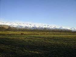
Kyungey Ala-Too near Bostery village | |
| Highest point | |
| Peak | Chok-Tal Peak |
| Elevation | 4,771 m (15,653 ft) |
| Dimensions | |
| Length | 280 km (170 mi) E-W |
| Width | 32 km (20 mi) N-S |
| Naming | |
| Etymology | in Kyrgyz and Kazakh meaning "adret mottled mountains" |
| Geography | |
| Countries | Kyrgyzstan and Kazakhstan |
| State/Province | Issyk Kul Province |
The Küngöy Ala-Too (Kyrgyz: Күңгөй Ала-Тоо, [küŋgöj alatoː]), also spelled Kyungei Alatoo, Kungey Ala-Too, and Kungey Alatau, is a range in the North Tien-Shan. Its length is about 280 km and it stretches from Boom Gorge to Kegen - Karkyrin valley. The highest point of the range is Peak Chok Tal (4770 m).[1]
References
Coordinates: 42°46′34″N 76°41′24″E / 42.7762°N 76.6900°E
This article is issued from Wikipedia - version of the 6/21/2015. The text is available under the Creative Commons Attribution/Share Alike but additional terms may apply for the media files.