Kumamoto Prefecture
| Kumamoto Prefecture 熊本県 | |||
|---|---|---|---|
| Prefecture | |||
| Japanese transcription(s) | |||
| • Japanese | 熊本県 | ||
| • Rōmaji | Kumamoto-ken | ||
| |||
 | |||
| Coordinates: 32°43′N 130°40′E / 32.717°N 130.667°ECoordinates: 32°43′N 130°40′E / 32.717°N 130.667°E | |||
| Country | Japan | ||
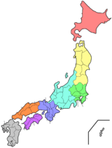
| Region | Kyushu | ||
| Island | Kyushu | ||
| Capital | Kumamoto | ||
| Government | |||
| • Governor | Ikuo Kabashima | ||
| Area | |||
| • Total | 7,404.14 km2 (2,858.75 sq mi) | ||
| Area rank | 16th | ||
| Population (May 1, 2011) | |||
| • Total | 1,812,255 | ||
| • Rank | 23rd | ||
| • Density | 244.76/km2 (633.9/sq mi) | ||
| ISO 3166 code | JP-43 | ||
| Districts | 9 | ||
| Municipalities | 45 | ||
| Flower | Gentian (Gentiana scabra var. buergeri) | ||
| Tree | Camphor tree (Cinnamomum camphora) | ||
| Bird | Eurasian skylark (Alauda arvensis) | ||
| Website |
www | ||


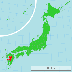
Kumamoto Prefecture (熊本県 Kumamoto-ken) is a prefecture of Japan located on the island of Kyushu.[1] The capital is the city of Kumamoto.[2]
History
Historically, the area was called Higo Province; and the province was renamed Kumamoto during the Meiji Restoration.[3] The creation of prefectures was part of the abolition of the feudal system. The current Japanese orthography for Kumamoto literally means "bear root/origin", or "origin of the bear".
Geography

Kumamoto Prefecture is in the center of Kyushu, the southernmost of the four major Japanese islands. It is bordered by the Ariake inland sea and the Amakusa archipelago to the west, Fukuoka Prefecture and Ōita Prefecture to the north, Miyazaki Prefecture to the east, and Kagoshima Prefecture to the south.
Mount Aso (1592 m), an extensive active volcano, is in the east of Kumamoto Prefecture. This volcano is located at the centre of the Aso caldera.
As of March 31, 2008, 21% of the total land area of the prefecture was designated as natural parks: the Aso Kujū and Unzen-Amakusa National Parks; Kyūshū Chūō Sanchi and Yaba-Hita-Hikosan Quasi-National Parks; and Ashikita Kaigan, Itsuki Gokanoshō, Kinpōzan, Misumi-Ōyano Umibe, Okukuma, Shōtaisan, and Yabe Shūhen Prefectural Natural Parks.[4]
Cities
Fourteen cities are located in Kumamoto Prefecture:


Towns and villages
These are the towns and villages in each district:

Mergers
Demographics
The population is 1,812,255. The prefecture ranks 23rd in Japan. The population density is 244.76 people per square kilometer.
Economy


There is a Honda automobile plant.
Tourism
- Mount Aso is one of the world's largest active volcanoes.
- Kumamoto Castle
- Suizenji Park
- Tsūjun Bridge, the largest stone aqueduct in Japan is in Yamato
Education
Universities
National
Public
Private
- Kumamoto Gakuen University
- Kumamoto Health Science
- Kyushu University of Nursing and Social Welfare
- Kyushu Lutheran College
- Kumamoto Health Science
- Shokei Gakuin University
- Sojo University
- Heisei College of Music
- Tokai University of Kumamoto
Transportation
Rail
- JR Kyushu
- Kumamoto Electric Railway
- Kumagawa Railroad
- South Aso Railway
- Hisatsu Orange Railway
Tramway
Road
Expressways and toll roads
- Kyushu Expressway
- South Kyushu Expressway
- Kumamoto Amakusa Road
National highways
- Route 3
- Route 57
- Route 208 (Kumamoto-Tamana-Arao-Ōmuta)
- Route 212
- Route 218 (Kumamoto-Takachiho-Nobeoka)
- Route 219
- Route 265
- Route 266
- Route 267 (Hitoyoshi-Isa-Satsuma-Satsumasendai)
- Route 268
- Route 324
- Route 325 (Yamaga-Minamiaso-Takamori-Takachiho)
- Route 387
- Route 388 (Saiki-Nobeoka-Unomae)
- Route 389
- Route 442
- Route 443
- Route 445
- Route 501 (Ōmuta-Arao-Udo)
- Route 503
Ports
Ferry routes
Airport
Sports

These sports teams are based in the prefecture:
- Professional:
- Roasso Kumamoto - Men's football and J League Second Division
- Blaze Kumamoto - Men's association football
- Mashiki Renaissance Kumamoto - Women's association football
- Amateur:
- Kumamoto Golden Larks - regional baseball
Sister cities
Kumamoto Prefecture is the 'sister state/prefecture' of Montana in the United States.
Kumamoto has a sister city located in Texas named San Antonio, which holds an annual fall festival 'akimatsuri' for its Japanese citizens. In 2015 the mascot, 'Kumamon' visited as an honorary ambassador during the festival located at the Japanese Tea Gardens.
Notable people
- Tetsu Komai, a hollywood actor
- Kazuaki Kiriya, a filmmaker
- Kimeru, a pop artist
- Moe Kamikokuryou, a Japanese idol
- Yuri Masuda, singer
- Tomiko Van, singer, vocalist of Do As Infinity
- Eiichiro Oda, manga author, creator of One Piece
- Yu Todoraki, actress
- Tetsuya Noda, Contemporary artist
- Katsuhito Ueo, Drifting driver
Notes
- ↑ Nussbaum, Louis-Frédéric. (2005). "Kumamoto prefecture" in Japan Encyclopedia, p. 572, p. 572, at Google Books.
- ↑ Nussbaum, "Kumamoto" in p. 572, p. 572, at Google Books.
- ↑ Nussbaum, "Provinces and prefectures" in p. 780, p. 780, at Google Books.
- ↑ "General overview of area figures for Natural Parks by prefecture" (PDF). Ministry of the Environment. Retrieved 8 February 2012.
References
- Nussbaum, Louis-Frédéric and Käthe Roth. (2005). Japan encyclopedia. Cambridge: Harvard University Press. ISBN 978-0-674-01753-5; OCLC 58053128
External links
| Wikimedia Commons has media related to Kumamoto prefecture. |
| Wikivoyage has a travel guide for Kumamoto_prefecture. |
- Official website
- National Archives of Japan ... Kumamoto map (1891)
| Wards of Kumamoto | ||
|---|---|---|
| Cities | ||
| Amakusa District | ||
| Ashikita District | ||
| Aso District | ||
| Kamimashiki District | ||
| Kikuchi District | ||
| Kuma District | ||
| Shimomashiki District | ||
| Tamana District | ||
| Yatsushiro District | ||