Kuiu Wilderness and Tebenkof Bay Wilderness
| Kuiu Wilderness | |
|---|---|
|
IUCN category Ib (wilderness area) | |
|
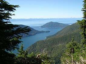
Overlooking Port Malmesbury in the Kuiu Wilderness on Kuiu Island, Alaska. | |
 | |
| Location | Unorganized Borough, Alaska, USA |
| Nearest city | Kake, Alaska |
| Coordinates | 56°17′18″N 134°04′59″W / 56.28833°N 134.08306°WCoordinates: 56°17′18″N 134°04′59″W / 56.28833°N 134.08306°W[1] |
| Area | 60,581 acres (245.16 km2) |
| Established | November 28, 1990 |
| Governing body | U.S. Forest Service |
| Tebenkof Bay Wilderness | |
|---|---|
|
IUCN category Ib (wilderness area) | |
| Location | Unorganized Borough, Alaska, USA |
| Nearest city | Kake, Alaska |
| Area | 66,812 acres (270.38 km2) |
| Established | December 2, 1980 |
| Governing body | U.S. Forest Service |
The Kuiu Wilderness and Tebenkof Bay Wilderness are federally designated wilderness areas within the Tongass National Forest, located on Kuiu Island, Petersburg Census Area, Alaska. The 60,581-acre Kuiu and 66,812-acre Tebenkof Bay wildernesses are managed by the United States Forest Service as a single area — creating a 200-square-mile wilderness preserve covering the heart of the island.[2][3] Together, the two areas protect old-growth temperate rainforests rising from coastal estuaries to subalpine meadows more than 2,000 feet in elevation, with a high point atop 3,355-foot Kuiu Mountain.[2][4]
Tebenkof Bay Wilderness was created by Congress and signed into law on December 2, 1980 as a provision of the Alaska National Interest Lands Conservation Act.[5][6] The Kuiu was created by Congress and signed into law on November 28, 1990 as part of the Tongass Timber Reform Act.[5]
Ecology and history
The landscape of Kuiu Island has much in common with other areas of the Alexander Archipelago — heavily-glaciated mountains alternating with narrow, deep fjords. Within the wilderness areas can be found a variety of ecological communities, including muskeg, Pacific temperate rain forest dominated by Sitka spruce and western hemlock, and alpine tundra zones as low as 2,000 feet above sea level.[2] Prior to European colonization, significant populations of Tlingit native people lived on the island, particularly in Tebenkof Bay.[2]
Recreation

Access to the wilderness is possible only by boat or floatplane, with the most convenient Alaska Marine Highway ferry terminal being in Kake.[2] One rustic camping shelter is available on a first-come, first-served basis, located near the shoreline of the Bay of Pillars.[7] The shelter was built in 1997, but was designed to be reminiscent of those constructed in the 1930s by Civilian Conservation Corps crews working in Southeast Alaska.[8]
The two wilderness areas are a popular destination for kayaking and canoeing, offering experienced backcountry paddlers a mix of peaceful, sheltered waterways and difficult, open-ocean traverses. Several portages are available when seas are particularly treacherous.[2][4][9]
See also
-
 Alaska portal
References
- ↑ Kuiu Wilderness, Geographic Names Information System, United States Geological Survey.
- 1 2 3 4 5 6 Wilderness Areas of the Petersburg Ranger District, Tongass National Forest, United States Forest Service.
- ↑ Kuiu Island Wilderness Areas, Cape Decision Lighthouse Society
- 1 2 Kuiu Wilderness, Wilderness.net
- 1 2 What Can I Do In Wilderness? Alaska National Interest Lands Conservation Act and Wilderness on National Forests in Alaska, United States Forest Service.
- ↑ Tebenkof Bay Wilderness, Wilderness.net
- ↑ Bay of Pillars Shelter, Tongass National Forest, United States Forest Service.
- ↑ Bay of Pillars Shelter, Petersburg Ranger District, Tongass National Forest, United States Forest Service.
- ↑ Kuiu Island/Tebenkof Bay Canoe/Kayak Routes, Leaflet R10-RG-3, Tongass National Forest, United States Forest Service
External links
- Wilderness Areas of the Petersburg Ranger District - Tongass National Forest official site
- Kuiu Wilderness - Wilderness.net
- Tebenkof Bay Wilderness - Wilderness.net