Kuala Krai District
| Kuala Krai District | ||
|---|---|---|
| District of Malaysia | ||
 | ||
| ||
| Country |
| |
| State |
| |
| Seat | Kuala Krai | |
| Government | ||
| • District officer | n/a | |
| Area[1] | ||
| • Total | 2,329 km2 (899 sq mi) | |
| Population (2009) | ||
| • Total | 117,800 | |
| • Density | 51/km2 (130/sq mi) | |

Kuala Krai (alternative spelling: Kuala Kerai) is a district (jajahan), a town and a parliamentary constituency in the interior of the State of Kelantan in the north-east of Malaysia. Historically, it was known as Kuala Lebir.[2]
Kuala Krai territory
Kuala Krai territory is a landlocked administrative area in the centre of the State of Kelantan in the north east of Malaysia. The land is hilly, and before the 20th century the entire area was tropical rain forest. The territory contains the confluence of two major rivers, the Lebir and Galas, to form the Kelantan River, which then flows some 70 km northwards through one of the most densely populated flood plains on the Malay Peninsula to its estuary in the South China Sea near the State capital of Kota Bharu.
As transport links improved during the 20th century, people moved into the area to take advantage of the abundant land available for farming. A railway was constructed in the 1920s through the undeveloped interior of Malaysia to link Kelantan State with the main centres of population on the west coast. This line ran through Kuala Krai territory, and settlements became established along its route. Road links followed, and towns and villages grew to cater for the mainly agricultural population. Rubber production was increasingly important throughout Malaysia, and many rubber tree plantations were set up in this area. Later, the country-wide shift to oil palm in the 1970s and 1980s saw the establishment of oil palm plantations in the territory, some of which replaced rubber.
Infrastructure developed to support the population and by the end of the 20th century Kuala Krai town had become a busy thriving town, and the administrative centre for the territory.
Demographics
The territory "Jajahan Kuala Krai" has an area of 2329 km² and comprises three administrative districts (daerah):[1]
- Daerah Olak Jeram (757.6 km²) with 67 villages
- Daerah Batu Mengkebang (726.9 km²) with 122 villages
- Daerah Dabong (844.5 km²) with 27 villages
Some of the better known towns and villages in the territory include Dabong, Kemubu, Manek Urai, Kampung Pahi, Kampung Peria and Kampung Laloh.
Secondary Schools
The secondary schools in the territory are:[3]
- Maahad Rahmaniah Padang Sembilan (SMU (A)Rahmaniah), 18000 Kuala Krai
- Sekolah Menengah Kebangsaan Dabong (SMK Dabong), 18200 Dabong
- Sekolah Menengah Kebangsaan Keroh (SMK Keroh), 18000 Kuala Krai
- Sekolah Menengah Kebangsaan Laloh (SMK Laloh), 18000 Kuala Krai
- Sekolah Menengah Kebangsaan Manek Urai (SMK Manek Urai), 18050 Kuala Krai
- Sekolah Menengah Kebangsaan Mengkebang (SMK Mengkebang), 18000 Kuala Krai
- Sekolah Menengah Kebangsaan Pahi (SMK Pahi), 18000 Kuala Krai
- Sekolah Menengah Kebangsaan Sultan Yahya Petra (1) (SMK Sultan Yahya Petra (1)), 18000 Kuala Krai
- Sekolah Menengah Teknik Kuala Krai (SM Teknik Kuala Krai), 18000 Kuala Krai
- Sekolah Menengah Kebangsaan Kuala Krai (SMK Kuala Krai), Sungai Durian, 18000 Kuala Krai
- Sekolah Menengah Kebangsaan Sultan Yahya Petra (2) (SMK Sultan Yahya Petra (2)), 18000 Kuala Krai
- Maktab Rendah Sains Mara Kuala Krai*Fews Sekolah Menengah Ugama
Population
The population of Kuala Krai territory was 117,800 in 2009.
Ranking Population Jajahan Kuala Krai.
| Rank | Daerah/Mukim | Population 2000 |
|---|---|---|
| 1 | Batu Mengkebang | 55,975 |
| 2 | Olak Jeram | 24,665 |
| 3 | Dabong | 11,131 |
Population ethnicity
The population and ethnicity of the territory is as follows:[1]
| Race | 1990 | % | 1995 | % | 2000 | % | 2004 | % | |||
|---|---|---|---|---|---|---|---|---|---|---|---|
| Malay | 92,916 | 91.4 | 110,246 | 90.9 | 130,810 | 90.9 | 149,018 | 90.8 | |||
| Chinese | 5,685 | 5.6 | 7,282 | 6.0 | 8,657 | 6.0 | 9,862 | 6.0 | |||
| Indian | 2,650 | 2.6 | 3,364 | 2.7 | 3,990 | 2.8 | 4,545 | 2.7 | |||
| Other | 354 | 0.4 | 121,339 | 0.4 | 463 | 0.3 | 527 | 0.3 |
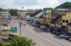
Kuala Krai town
Kuala Krai town is about 64 km south of the State capital, Kota Bharu.
- location: 5°32′0″N 102°12′0″E / 5.53333°N 102.20000°E
- altitude: 53 metres (177 ft)
- postcode: 18000
| Year | 1980 | 1991 | 2000 |
|---|---|---|---|
| Population in thousands | 12.6 | 19.8 | 19.5 |
History
The history of the town of Kuala Krai started with the building of the East Coast Railway in the 1920s. Before that, the only settlement of any significance in the area was called Batu Mengkebang. The area was remote and travel was by river: there was a weekly service from Kota Baru to Batu Mengkebang via Pasir Mas and Tanah Merah, run by Duff Development River Steamers under contract to the Kelantan Government.[5]
The opening of the railway line made a significant difference to the remote interior of the state of Kelantan. River traffic downstream from Kuala Krai was soon completely replaced by rail travel, and the railway became very popular with what was still quite a large planting fraternity in the interior of the state. The town grew as a centre of trade and supplies for the surrounding area.
More recently, road traffic past the town has significantly increased with the proximity of Federal Route 8 which opens a direct road link between Kota Bharu and the Malaysian capital, Kuala Lumpur. The suburb of Gucil has developed along this road to take advantage of the increased traffic.
Some important events in the history of the town:
- 1917 Kuala Krai hospital was opened
- 1926 (December) The great flood, the worst flood in the history of the town, which affected both Kelantan and the neighbouring states of Terengganu and Perak
- 1930 (19 June) Visit of Sir Cecil Clementi, Governor of the Straits Settlements and High Commissioner for Malaya 1930-1934,[6] after which he travelled on the newly constructed railway to Pahang
- 1941 The Japanese invasion force landed at Kota Bharu on 8 December and allied troops retreated; 2nd Lieutenant Butters and his section of Mahrattas were left behind in Kuala Kerai with a battalion of the Royal Malay Regiment; before leaving the town they attempted to impede Japanese progress using explosives to prevent the railway line being used by the advancing Japanese[7]
- 1945 Immediately after the war ended, Kuala Krai was controlled by the communists for about six months before the arrival of allied forces[8]
- 1946 Serious flooding affected the town[8]
- 1961 Opening of the Mini Zoo
- 1967 (26 Nov) Severe flooding: the water level of the Kelantan River rose to 86 ft (26 m), which is 36 ft (11 m) above the normal level[9] Large areas of the town were flooded up to first floor level.
- 1967 (Dec) forced landing of an M.S.A. plane at Kuala Kerai which nearly had fatal consequences to the passengers[10]
Infrastructure
Transport
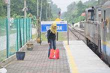
Kuala Krai has excellent transport links. The railway station operated by Keretapi Tanah Melayu (KTM) is on the East Coast Line which runs from Tumpat and Wakaf Bharu (close to Kota Bharu) right through the interior parts of Kelantan and Pahang to Gemas on the west of the peninsula, where it joins the West Coast Line from Singapore to Kuala Lumpur. The town has good road links, with Federal Route 8 passing close to the town. It is also located on the western bank of the Kelantan River, along which there are regular boat services up-river from the town.
General Hospital
Hospital Kuala Krai (HKK) opened in 1917, built on a small hill close to the town. Also known as Hospikrai, it serves a population of 200,000 in the southern part of Kelantan, and has 120 beds and 218 staff.[11] The hospital has resident specialists in Obstetrics & Gynecology, Pediatrics, Surgery, Anesthesiology, Pathology and Medical; there are visiting specialists from Kota Bharu for work in Psychiatric, Dermatology, Ophthalmology, Orthopedic and ENT.[12]
Museum and Mini Zoo
Kuala Krai Mini Zoo[13] is managed by the District Council and open to the public. It is home to a variety of animals, including a male elephant called "Salleh",[14] monkeys, bears, deer and various birds. The site extends to about 10 acres (40,000 m2), and also includes a Mini Museum displaying photographs and documents relating to the history of Kuala Krai, as well as a number of preserved animals. The mini zoo was opened in 1961 and is the only zoo to specialise exclusively in animals from the Malaysian jungle.
Public Library
There is a small public library in the town which, as well as giving access to its collection of books, affords public access to the internet for a small charge.
Kuala Krai Steps (formerly the Bradley Steps)
Eighty-one concrete steps leading down from the town to the river bank and boat jetty were constructed sometime between 1927 and 1929, and were named the Bradley Steps after a Mr. Gerald Bradley who was the energetic District Officer of the interior of Kelantan at the time. They have recently been renamed the Kuala Krai Steps.
Just upstream from the town is the confluence of the Lebir and Galas rivers to become the Kelantan river, and it became clear that an elevated river level at the Bradley Steps was a good predictor of imminent flooding in the cultivated and populated river basin further downstream. Consequently, stick gauges were placed by the steps so that the river level could be read and monitored by the local police, who transmitted the rainfall and water level information via VHF sets to the Flood Warning and Relief Committee in Kota Bharu.[15]
The Kelantan Department of Drainage and Irrigation has since replaced the stick gauges with metric plates. This facilitates the prediction of flood levels and lead-times in villages all the way from Kuala Krai to the river estuary.[16] The steps, and the floodwater level, can be seen on the Kuala Krai Flood Webcam.
Education
There are a number of schools and colleges in the town, including:
- SMU (Arab) Rahmaniah, Padang Sembilan Kuala Krai
- SMK Sultan Yahya Petra 1
- SMK Sultan Yahya Petra 2
- SK Banggol Guchil
- SMK Kuala Krai
- MRSM Kuala Krai
- SM Teknik Kuala Krai
- SMK Bandar Kuala Krai
- SK Bandar Kuala Krai
- RISDA College
- SMK Pahi
- SM Laloh
- Open University Malaysia (OUM)
Shopping
- Econjaya
- Pantai Timor Shopping Centre
- Jaya Gading
- Pasaraya PKT
- Tesco (Proposed)
- MYDIN Mall Bandar Chintawangsa (Coming Soon)
- Plaza Chintawangsa (Upcoming)
Other
- Batu Jong Training Camp, a national service training camp, opened in January 2005
- Lake Gardens (Taman Tasik), a pleasant public space in the town
- Lata Rek, Known to be a hydroelectric dam, is also a popular spot with a nice waterfall and recreational area and homestay
Famous people from Kuala Krai
- Loh Sea Keong, Malaysian professional cyclist
- Mee Fong, a commercial photographer, had a studio in Kuala Krai in 1930[17]
- Mohd Khairul Anuar also known as Lan Cairo, who is an artist and prestige man born in Kuala Krai on Dragon Years 27 May 1988. He is very good personal rapport with international people as well representative of Malays in the worlds.
- Datuk Rafiah Salim, is the first female Vice-Chancellor in Malaysia, posted to Universiti Malaya.
- T. Wignesan, writer, was born in Kuala Krai in the early 1930s[18][19]
- Tengku Budriah binti Al-Marhum Tengku Ismail, the Raja Perempuan of Perlis, was born in Kuala Krai on 28 March 1924. Her husband, Almarhum Tuanku Syed Putra ibni Almarhum Syed Hassan Jamalullail was elected as the third King of Malaysia (known as Yang di-Pertuan Agong) from 1960 to 1965.[20]
- Terence Fernandez, a Journalist and current deputy editor special reports & investigations of The Sun Newspaper. He was kidnapped in Iraq in 2003 but survived and currently writes a column in The Sun every Tuesday and Thursday, frequently writing on corruption and mismanagement of funds by politicians. He grew up in Kuala Krai and spent his entire childhood and teenage years there.[21]
- Zang Toi, New York fashion designer, was born in Kuala Krai on 11 June 1961[22]
Politics
Kuala Krai is represented in the Malaysian Parliament by Dr. Mohd Hatta Ramli from Amanah. He was previously from PAS, which he left in 2015 and became a founding member of Amanah. The parliamentary seat of Kuala Krai is divided into four state seats:
See also
| Wikimedia Commons has media related to Kuala Krai. |
References
- 1 2 3 "Profail Jajahan Kuala Krai". Pejabat Tanah dan Jajahan Kuala Krai. Archived from the original on 12 March 2008. Retrieved 23 October 2007.
- ↑ "Map of British Malaya Including The Straits Settlements Federated Malay States and Malay States Not Included In The Federation 1924". Retrieved 26 April 2016.
- ↑ "Secondary Schools in Kelantan, Malaysia". 2007. Retrieved 6 December 2007.
- ↑ Jan Lahmeyer (2004). "Malaysia - historical demographic data of the urban centers". populstat. Archived from the original on 2 May 2006. Retrieved 12 December 2006.
- ↑ Shukor Rahman. "Kuala Krai, a town that owes its origin, growth to the railway". scanned local newspaper cutting, probably dating from the early 1970s. Retrieved 5 May 2007.
- ↑ Janus project. "Photograph collection of the British Association of Malaysia and Singapore". Janus catalogue. Retrieved 9 December 2006.
- ↑ Lieutenant Colonel Edward De Santis (2001). "Major MICHAEL DELMÉ-RADCLIFFE". Ubique. Retrieved 14 December 2006.
- 1 2 Butz, William, and Julie DaVanzo. FIRST MALAYSIAN FAMILY LIFE SURVEY, 1976-1977 [Computer file]. 2nd ICPSR version. Santa Monica, CA: RAND [producer], 1995. Ann Arbor, MI: Inter-university Consortium for Political and Social Research [distributor], 1998. mfls1smp.pdf
- ↑ "Major Floods". Bernama Library and Infolink Service. 2004. Retrieved 9 December 2006.
- ↑ "Questions for Oral Answers" (PDF). Second House of Representatives Malaysia - Fourth Session - Order Paper. Parlimen Malaysia. 12 February 1968. Archived from the original (PDF) on 30 August 2008. Retrieved 24 February 2008.
- ↑ Dr. Roslan (1998). "Case Abstract- 'Hospikrai Can'". National Institute of Public Administration (INTAN), Malaysia. Retrieved 3 March 2008.
- ↑ Zawawi Hassan (2003). "Specialist Services - Khidmat Pakar". HOSPITAL KUALA KRAI. Archived from the original on 26 October 2009. Retrieved 3 March 2008.
- ↑ The Ministry of Tourism, Malaysia. "Kuala Krai Mini Zoo". Virtual Malaysia. Archived from the original on 31 December 2006. Retrieved 9 December 2006.
- ↑ "Kuala Krai Mini Zoo". Elephant facts and information database. Retrieved 13 October 2008.
- ↑ Ketua Pengarah Jabatan Pengairan & Saliran Malaysia (Ministry of Natural Resources & Environment) (21 June 2007). "Flood and Drought Management in Malaysia". Deraf Teks Ucapan: (page 9). Archived from the original (.doc) on 1 October 2008. Retrieved 12 October 2008.
- ↑ Department of Drainage and Irrigation of Kelantan (2005). "The Bradley Steps, Kuala Krai". DID Kelantan History - Structures of Historical Significance. Retrieved 9 December 2006.
- ↑ Cambridge University Library (2004). "Mee Fong, fl 1930, photographer". RCS Photographers Index. Retrieved 14 December 2006.
- ↑ Netconcepts, LLC. "T. Wignesan". WritersNet. Retrieved 11 December 2006.
- ↑ T Wignesan (2006). "Curriculum Vitae". Retrieved 11 December 2006.
- ↑ Perpustakaan Negara Malaysia (2003). "Yang di-Pertuan Agong III". Malaysian Monarchy. Archived from the original on 27 October 2005. Retrieved 10 December 2006.
- ↑ http://www.sun2surf.com/
- ↑ Star Publications (Malaysia) (2003). "Designer dreams". All Malaysia.info. Retrieved 10 December 2006.
Capital: Kota Bharu | |||||||||||
| Topics |
| ||||||||||
| Society |
| ||||||||||
| Administrative divisions |
| ||||||||||
| |||||||||||