Kovachevsko kale
| Kovachevsko kale | |
|---|---|
|
Aerial photo of the fortress | |
 Location within Bulgaria | |
| Founded during the reign of | Licinius or Constantine I |
| Founded | early 4th century AD |
| Abandoned | late 6th century AD |
| Place in the Roman world | |
| Province | Moesia Secunda |
| Structure | |
| — Stone structure — | |
| Size and area | (4 - 5.2 ha) |
| Shape | Roughly triangular |
| Wall thickness | 3 - 3.5 m |
| Location | |
| Town | Kovachevets, near Popovo |
| County | Targovishte |
| Country |
|
| Site notes | |
| Condition | Ruined |
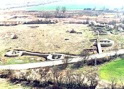
Kovachevsko kale (Bulgarian: Ковачевско кале) is a late Roman fortress, whose ruins are 6 kilometres (4 mi) west of the Bulgarian town of Popovo, near the modern road Popovo - Byala. The ancient name of the settlement is unknown. The Czech archaeologist Karel Škorpil called it Kovachoveshko kale, after the name of the nearby village, Kovachevets (at that time Kovachovets).
The fortress is on a flat terrain, naturally protected by low-water rivers. It has a roughly triangular form. The defensive stone walls are fortified with 17 U-shaped towers. There are two gates, one to the west, to other one to the north-east.


 Undeciphered Latin inscription discovered outside the northern wall.
External links
- Kovatchevsko kale - a 3D reconstruction by Marhis Architectural Studio
- Bulgarian castles - Kovachevsko kale (Bulgarian)
This article is issued from Wikipedia - version of the 11/27/2016. The text is available under the Creative Commons Attribution/Share Alike but additional terms may apply for the media files.