Korsholm
| Korsholm Korsholm – Mustasaari | ||
|---|---|---|
| Municipality | ||
| Korsholms kommun – Mustasaaren kunta | ||
|
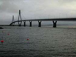
The Replot Bridge on a grey autumn day | ||
| ||
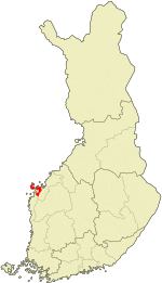 Location of Korsholm in Finland | ||
| Coordinates: 63°06′45″N 021°40′40″E / 63.11250°N 21.67778°ECoordinates: 63°06′45″N 021°40′40″E / 63.11250°N 21.67778°E | ||
| Country | Finland | |
| Region | Ostrobothnia | |
| Sub-region | Vaasa sub-region | |
| Charter | 1348 | |
| Government | ||
| • Municipal manager | Rurik Ahlberg | |
| Area (2011-01-01)[1] | ||
| • Total | 3,178.63 km2 (1,227.28 sq mi) | |
| • Land | 848.14 km2 (327.47 sq mi) | |
| • Water | 2,330.49 km2 (899.81 sq mi) | |
| Area rank | 18th largest in Finland | |
| Population (2016-03-31)[2] | ||
| • Total | 19,308 | |
| • Rank | 61st largest in Finland | |
| • Density | 22.77/km2 (59.0/sq mi) | |
| Population by native language[3] | ||
| • Swedish | 70.2% (official) | |
| • Finnish | 28.7% (official) | |
| • Others | 1% | |
| Population by age[4] | ||
| • 0 to 14 | 19.4% | |
| • 15 to 64 | 63.9% | |
| • 65 or older | 16.7% | |
| Time zone | EET (UTC+2) | |
| • Summer (DST) | EEST (UTC+3) | |
| Municipal tax rate[5] | 19.75% | |
| Website | www.korsholm.fi | |

Korsholm (Finnish: Mustasaari) is a municipality of Finland. The town of Vaasa was founded in Korsholm parish in 1606 and today the municipality completely surrounds the city. It is a coastal, mostly rural municipality, consisting of a rural landscape and a large, fractured archipelago. The administrative center is Smedsby (Finnish: Sepänkylä), situated 3 km (2 mi) from Vaasa center along Finnish national road 8.
Geography
It is located in the province of Western Finland and is part of the Ostrobothnia region. The municipality consists of the central areas, the southern plain, and the extensive archipelago. Parts of the archipelago belong to the UNESCO World Heritage Site of Kvarken (Finnish: Merenkurkku).
One of Korsholm's more notable landmarks is that it holds Finland's longest bridge, the Replot Bridge (Finnish: Raippaluodon silta). The bridge connects the island of Replot (Finnish: Raippaluoto) to the mainland. Finland's second oldest stone bridge that is still in use, can also be found in Korsholm, in the village of Toby (Finnish: Tuovila).
Major islands in the archipelago include Replot, Björkö, Köklot, Panike and the Valsörarna archipelago.
Along the coast, Korsholm extends to two river outlets: Kyrönjoki river flows into the Vassor bay of the Gulf of Bothnia, and the Laihianjoki river flows into Vanhankaupunginlahti, the bay on whose shore the city of Vaasa is located.
Villages

Anixor, Brändövik, Böle, Björköby, Västerhankmo, Österhankmo, Helsingby, Iskmo, Jungsund, Kalvholm, Karkmo (Finnish: Karkkimala), Karperö, Köklot (Kaukaluoto), Kvevlax (Koivulahti), Koskö, Kuni, Martois (Martoinen), Miekka, Munsmo, Norra Vallgrund, Panike, Petsmo (Petäjänmaa), Pundars (Puntainen), Replot (Raippaluoto), Rimal (Riimala), Runsor, Singsby, Smedsby (Sepänkylä), Solf (Sulva), Söderudden, Södra Vallgrund, Staversby (Taurila), Toby (Tuovila), Tölby, Vassor, Veikars (Veikkaala), Vikby, Vistan, Voitby (Voitila). (Most villages have only a Swedish name.)
Demographics
The municipality has a population of 19,308 (31 March 2016)[2] and covers an area of 3,178.63 square kilometres (1,227.28 sq mi) of which 2,330.49 km2 (899.81 sq mi) is water.[1] The population density is 22.77 inhabitants per square kilometre (59.0/sq mi).
The municipality is bilingual, with a majority (70%) being Swedish and a minority (29%) Finnish speakers.[3] The Finnish speakers are concentrated near the enclosed city Vaasa, particularly in Smedsby (Finnish: Sepänkylä), and in the villages of Toby (Finnish: Tuovila) and Kvevlax (Finnish: Koivulahti) in the southern plain, while the rest of the municipality is Swedish-speaking.
In a 2016 statistical comparison of municipalities by Yle,[6] Korsholm was rated 5/5 for viability and health and 4/5 for atmosphere (concerning e.g. education, crime and leisure), but only 2/5 for economy. Exceptionally good results were found in violent crime, which occurs at a rate of 1.9 per 1,000 inhabitants vs. the national average of 5.6, in the number of alcoholics and other addicts, at 0.6 per 1,000 inhabitants, vs. the national average of 3.3, and the proportion of youth smoking at 6.0%, vs the national average of 14.2%. Concerns were mainly economic: the employment self-sufficiency is only 57% vs. 89%, the equity ratio is poor (34.8% vs. 51.9%) and indebtedness is relatively high (70.4% vs. 48%), despite the municipal tax being the same as the national average (20.75%). Korsholm has relatively little industry and commuting to Vaasa is very common. Korsholm is neither losing nor gaining inhabitants by migration.
History
Name
The original Finnish name Mustasaari "Black Island" may have been a medieval island cleared by a wildfire or an island that looks dark when approaching from the sea.[7] Due to isostatic uplift, the area referred to is now inland. The parish is first mentioned as Mustasaari parish in 1348. In Swedish, the pronunciation developed into Mussor, although the form Mustasaari remained in use in the community. Mikael Agricola, the founder of written Finnish, spelled it Mustsåår in 1530. In 1606–1611, it was known as Mussar, but in 1611 the city of Vaasa was founded in the parish and thus the parish was known as Vaasa. In 1772, it was known as "city of Vaasa and Mustasaari annex" (Vaasan kaupunki ja Mustasaaren anneksi), and in 1807–1867 "parish of Vaasa and Mustasaari" (Vaasan ja Mustasaaren seurakunta). Since then, Vaasa has been an independent parish. The municipality was named Korsholm in Swedish in 1927, after the medieval Korsholma castle.
Middle Ages
Korsholm has a history that can be dated back to 1348. In that year Korsholm was mentioned for the first time in writing in a royal letter concerning freedom of commerce. Therefore, the municipality celebrated its 650th anniversary in 1998. In the mid-14th century Saint Mary's Church was built in Korsholm island. The whole of Ostrobothnia was governed for hundreds of years from Korsholma Castle (Chrysseborg). The ruins of Saint Mary's Church and Korsholm Castle are now in the old town of Vaasa (Finnish: Vanha Vaasa; Swedish: Gamla Vasa).
1973 merger
Today's Korsholm municipality consists of five smaller municipalities that were merged in 1973: Korsholm in the center, Replot (Finnish: Raippaluoto) and Björköby in the far archipelago, Solf (Finnish: Sulva) in the southern plain and Kvevlax (Finnish: Koivulahti) in the eastern plain. To reflect the new, larger municipality the motif in the Korsholm coat of arms is five intertwined golden threads on a red background.
Twin towns – Sister cities
Korsholm is twinned with:
 Oskarshamn, Sweden[8]
References
- 1 2 "Area by municipality as of 1 January 2011" (PDF) (in Finnish and Swedish). Land Survey of Finland. Retrieved 9 March 2011.
- 1 2 "Ennakkoväkiluku sukupuolen mukaan alueittain, maaliskuu.2016" (in Finnish). Statistics Finland. Retrieved 31 March 2016.
- 1 2 "Population according to language and the number of foreigners and land area km2 by area as of 31 December 2008". Statistics Finland's PX-Web databases. Statistics Finland. Retrieved 29 March 2009.
- ↑ "Population according to age and gender by area as of 31 December 2008". Statistics Finland's PX-Web databases. Statistics Finland. Retrieved 28 April 2009.
- ↑ "List of municipal and parish tax rates in 2011". Tax Administration of Finland. 29 November 2010. Retrieved 13 March 2011.
- ↑ http://yle.fi/uutiset/3-9192528#Mustasaari
- ↑ Sirkka Paikkala. Suomalainen paikannimikirja. 2007, p. 276-277. Kotimaisten kielten tutkimuskeskus, Jyväskylä. ISBN 978-951-593-976-0
- ↑ Lindquist, Ted. "Internationella frågor och vänorter". Oskarshamn Municipality (in Swedish). Retrieved 2013-07-25.
External links
![]() Media related to Korsholm at Wikimedia Commons
Media related to Korsholm at Wikimedia Commons
| Municipalities |  | |
|---|---|---|
| Former municipalities | ||