Konyaaltı
| Konyaaltı | |
|---|---|
|
Konyaaltı Beaches | |
 Konyaaltı | |
| Coordinates: 36°50′20″N 30°28′52″E / 36.83889°N 30.48111°ECoordinates: 36°50′20″N 30°28′52″E / 36.83889°N 30.48111°E | |
| Country | Turkey |
| Province | Antalya |
| Government | |
| • Mayor | Muhittin Böcek (CHP) |
| • Kaymakam | Bayram Yılmaz |
| Population (2012)[1] | |
| • Urban | 125,849 |
| • District | 131,513 |
| Website |
www |
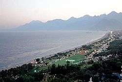
Konyaaltı is a district of Antalya, Turkey. The name "Konyaaltı" (pronounced [konja.aɫtɯ]), originates from the expression of "koy altı", which in the Turkish language means "the cove down the cliffs".
It is situated beneath the old city of Antalya extending miles toward the west, with various kinds of beaches including sand and shingle. The water is a little cooler compared to other beaches of Antalya because of an underground creek flowing to the sea. There are modern underground facilities for aesthetical reasons. Transportation is easy by means of buses etc. It is reachable by foot as well.
See also
References
- ↑ "Population of province/district centers and towns/villages by districts - 2012". Address Based Population Registration System (ABPRS) Database. Turkish Statistical Institute. Retrieved 2013-02-27.
External links
This article is issued from Wikipedia - version of the 9/29/2016. The text is available under the Creative Commons Attribution/Share Alike but additional terms may apply for the media files.