Konar Dam
| Konar Dam | |
|---|---|
 Konar Dam | |
 Location of Konar Dam (marked in red)in Jharkhand | |
| Location | Hazaribagh District, Jharkhand, India |
| Coordinates | 23°56′28″N 85°46′30″E / 23.94111°N 85.77500°ECoordinates: 23°56′28″N 85°46′30″E / 23.94111°N 85.77500°E |
| Opening date | 15 October 1955 |
| Dam and spillways | |
| Impounds | Konar River |
| Height | 48.77 metres (160.0 ft) |
| Length | 4,535 metres (14,879 ft) |
| Reservoir | |
| Surface area | 27.92 sq Km |
| Power station | |
| Operator(s) | Damodar Valley Corporation |
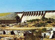
Konar dam (Hindi: कोनार बांध) is the second of the four multi-purpose dams included in the first phase of the Damodar Valley Corporation.. It was constructed across the Konar River, a tributary of the Damodar River in Hazaribagh district in the Indian state of Jharkhand and opened in 1955.[1] The place has scenic beauty and has been developed as a recreational spot.[2]
Konar Dam is 4,535 metres (14,879 ft) long and 48.77 metres (160.0 ft) high. The reservoir covers an area of 27.92 km2.[3]
DVC overview

As a result of the catastrophic flood of 1943, the Governor of Bengal appointed the Damodar Flood enquiry committee to suggest remedial measures. It suggested creation of an authority similar to that of the Tennessee Valley Authority in the United States. W.L.Voorduin, senior engineer of TVA prepared a preliminary report wherein he submitted an outline of a plan designed for achieving flood control, irrigation, power generation and navigation. As a result, Damodar Valley Corporation came into existence in 1948 for development and management of the basin as a whole. While Voorduin envisaged the construction of eight dams and a barrage but it was later decided to have only four dams at Tilaiya, Konar, Maithon and Panchet, and Durgapur Barrage.[4]
The first dam was built across the Barakar River at Tilaiya and inaugurated in 1953. The second dam across the Konar River was inaugurated in 1955. The third dam across the Barakar at Maithon was inaugurated in 1957. The fourth dam across the Damodar at Panchet was inaugurated in 1959.[5]
Transport
Konar Dam is located 41 kilometres (25 mi) south-east of Hazaribagh.[1]
References
- 1 2 "Konar Dam". india9.com. Retrieved 2010-04-17.
- ↑ Dr. B.R. Kishore, Dr. Shiv Sharma. India - A Travel Guide. Diamond Pocket Books (P) Ltd. p. 302. ISBN 9788128400674.
- ↑ "DVC". Konar. DVC. Retrieved 2010-04-17.
- ↑ Sharad K. Jain; Pushpendra K. Agarwal; Vijay P. Singh. "Hydrology and Water Resources of India". p. 395. Google books. Retrieved 2010-06-06.
- ↑ "Damodar Valley Corporation". Dams and Barrages. DVC. Retrieved 2010-06-06.
External links
| Wikimedia Commons has media related to Konar Dam. |
|
|