Kolding Municipality
| Kolding Municipality Kolding Kommune | ||
|---|---|---|
| Municipality | ||
|
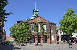
The rådhus (city hall), where the municipal council convenes. | ||
| ||
 | ||
| Country | Denmark | |
| Region | Southern Denmark | |
| Seat | City of Kolding | |
| Government | ||
| • Body | Municipal council | |
| • Mayor | Jørn Pedersen (Venstre) | |
| Area[1] | ||
| • Total | 604.5 km2 (233.4 sq mi) | |
| Population (2013)[1][2] | ||
| • Total | 89,556 | |
| • Density | 150/km2 (380/sq mi) | |
| Time zone | CET (UTC+1) | |
| • Summer (DST) | CEST (UTC+2) | |
| Postal codes | 6000, 6040, 6051, 6052, 6064, 6070, 6091, 6092, 6093, 6094, 6100, 6560, 6580, 6640[3] | |
| Website |
kolding | |


Kolding municipality is a municipality (Danish, kommune) in Region Syddanmark on the east coast of the Jutland peninsula in southeast Denmark. The municipality covers an area of 640 km², and has a total population of 87,781 (2008). Its mayor is Jørn Pedersen, a member of the Liberal Party (Venstre) political party. The main city and the site of its municipal council is the seaport city of Kolding, the sixth largest city in Denmark.
To the east is a strait, first called Snævringen ("The Narrowing") and then further south Bredningen ("The Broadening"), that separates the Jutland mainland from the island of Funen in this area, where the two lie very close to each other, often less than 1.5 km apart. Snævringen is an extension of the Kattegat, and begins near the cities of Fredericia and Middelfart, north and east of Kolding municipality. As Snævringen broadens it becomes Bredningen, which opens out into the Little Belt (Lillebælt), the main strait between Jutland and Funen. The municipality of Middelfart on the other side of Snævringen is thus Kolding's municipal neighbor to the east. The island of Fænø lies in Snævringen between Kolding and Middelfart.
Leading directly into the city of Kolding from Snævringen are the waters of Kolding Fjord.
Several major Danish motorways intersect in Kolding municipality. Middelfart municipality and Kolding municipality are connected by two bridges: the Old Little Belt Bridge and the New Little Belt Bridge.
On 1 January 2007 Kolding municipality was, as the result of Kommunalreformen ("The Municipal Reform" of 2007), merged with Christiansfeld, Lunderskov, and Vamdrup municipalities to form a new Kolding municipality.
Population
There are 18 cities and towns (as defined by Statistics Denmark as an urban area with a population of at least 200) in the municipality.[2] Of the 89,556 people living in the municipality, 78,695 reside permanently in an urban area, 10,759 reside in rural areas (including localities with less than 200 inhabitants).
- Kolding (57,583)
- Vamdrup (5,023)
- Lunderskov (3,016)
- Christiansfeld (2,898)
- Sønder Bjert (2,002)
- Almind (1,657)
- Vester Nebel (1,619)
- Sønder Stenderup (589)
- Jordrup (562)
- Viuf (558)
- Sjølund (502)
- Ødis (467)
- Skanderup (424)
- Hejls (421)
- Stepping (394)
- Hjarup (392)
- Taps (372)
- Ødis-Bramdrup (216)
Attractions
The former royal castle of Koldinghus is located in Kolding city. It was built in the 13th century by King Eric Glipping and is now a museum with certain parts of the castle, including its chapel and hall, being used for governmental ceremonial events. It was the last royal residence in Jutland.
Another notable site is the 13th century stone Church of Saint Nicholas, which is one of the oldest in Denmark.
Other popular tourist attractions include the Trapholt Art Museum and the Geographic Garden (Geografisk Have). Trapholt has a collection of Danish arts from 1900 onwards, as well as a smaller number of non-Danish exhibits.
Economy
Danish Air Transport has its head office in Vamdrup.[4]
References
- Municipal statistics: NetBorger Kommunefakta, delivered from KMD aka Kommunedata (Municipal Data)
- Municipal mergers and neighbors: Eniro new municipalities map
- 1 2 "De Kommunale Nøgletal". noegletal.dk. Ministry for Economic Affairs and the Interior. Retrieved 27 July 2013.
- 1 2 "BEF44: Population 1. January by urban areas". statbank.dk. Statistics Denmark. Retrieved 27 July 2013.
- ↑ "Postnumre i Danmark". regionsyddanmark.dk. Region of Southern Denmark. Retrieved 27 July 2013.
- ↑ "Contact DAT." Danish Air Transport. Retrieved on April 23, 2014. "Danish Air Transport A/S Lufthavnsvej 7A DK-6580 Vamdrup"
External links
| Vejle | Fredericia | ||
| Vejen | |
Kolding Fjord Little Belt | |
| |||
| | |||
| Haderslev |
Coordinates: 55°29′N 9°28′E / 55.49°N 9.47°E