Kolbuszowa
| Kolbuszowa | |||
|---|---|---|---|
|
Town well | |||
| |||
 Kolbuszowa | |||
| Coordinates: 50°15′N 21°46′E / 50.250°N 21.767°E | |||
| Country |
| ||
| Voivodeship |
| ||
| County | Kolbuszowa County | ||
| Gmina | Gmina Kolbuszowa | ||
| Established | 1503 | ||
| Town rights | 1700 | ||
| Government | |||
| • Mayor | Jan Zuba | ||
| Area | |||
| • Total | 7.94 km2 (3.07 sq mi) | ||
| Population (2007) | |||
| • Total | 9,510 | ||
| • Density | 1,200/km2 (3,100/sq mi) | ||
| Time zone | CET (UTC+1) | ||
| • Summer (DST) | CEST (UTC+2) | ||
| Postal code | 36-100 | ||
| Area code(s) | +48 17 | ||
| Car plates | RKL | ||
| Website | http://www.kolbuszowa.pl/ | ||
.jpg)

Kolbuszowa [kɔlbuˈʂɔva] is a small town in south-eastern Poland, with 9,190 inhabitants (02.06.2009).[1] Situated among the forests of Sandomierz Wilderness in the Subcarpathian Voivodship (since 1999), it is the capital of Kolbuszowa County. Kolbuszowa belongs to historic Lesser Poland, near its border with another historic region, Red Ruthenia.
History
The name of the town comes from the land owner Kolbusz. It appeared for the first time in 1503 in place where Poręby Wielkie used to exist. The town, which belonged to Sandomierz Voivodeship, was probably founded before 1683, when it was mentioned in a trade regulating document of Józef Karol Lubomirski. Kolbuszowa was located on an important trade route from Sandomierz to Przemyśl. As the owners of the area were the Leliwa Tarnowski, Kolbuszowa belonged to the Sandomierz County. With regards to the Roman Catholic Church Kolbuszowa was under the Kraków diocese but in 1786 it was moved under the jurisdiction of the Tarnów diocese.
During the partitions of Poland the town was in the Rzeszów district of the Austrian Galicia and in 1867 it became the seat of its own county (powiat). Before World War II, half of Kolbuszowa's population was Jewish. During the war, German troops burned down part of the town and about half of the Jewish population perished. In September 1941 Germans established a ghetto and interned 2500 people. In September 1942 the ghetto was emptied and its entire population was moved to a ghetto in Rzeszów.
On September 9, 1939 a 2-day battle[2] between the Polish Army (121st light tank company) and the German 2nd Panzer Division took place here. During the war units of Polish Armia Krajowa (AK) and BCh (Polish Peasants' Battalions) operating in this area discovered testing sites for the German V-1 and V-2 rockets in the nearby towns of Blizna/Pustkow. The Red Army entered Kolubuszowa in July 1944 and local Polish AK units (as part of Operation Tempest) attacked retreating German units; several dozen partisans died in the operation.
After World War II, Kolbuszowa was rebuilt. New school districts were created, as well as a library and Museum of Culture. In 1964, a new rail link was established: Rzeszów – Głogów Małopolski – Kolbuszowa. In 1971, it was extended to Nowa Dęba and Tarnobrzeg. This connected Kolbuszowa to all the major cities in Poland including the capital, Warsaw. It was a culmination of decades of preparations which started when this part of Poland was under the control of the Austro-Hungarian Empire.
Notable people
- Jan Bytnar, Scoutmaster, Polish Scouting resistance activist and Second Lieutenant of Armia Krajowa
- Marian Krzaklewski, Polish politician, was born in Kolbuszowa.
International relations
Twin towns — Sister cities
Kolbuszowa is twinned with:
Gallery
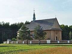 Saint Mark church from Rzochów
 Cottage from Sędzisz Małopolski in skansen at Folk Culture Museum
 Pottery workshop in skansen at Folk Culture Museum
_-_DSC04617_v3.jpg) County Governor's Office in Kolbuszowa
County Governor's Office in Kolbuszowa Train station
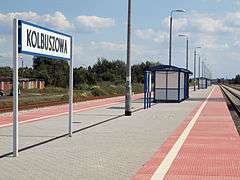 Pier at the train station
References
- Notes
- ↑ "Population. Size and structure by territorial division" (PDF). © 1995-2009 Central Statistical Office 00-925 Warsaw, Al. Niepodległości 208. 2009-06-02. Retrieved 2009-06-22. External link in
|publisher=(help) - ↑ "Vickers Mk.E tank in Polish service". Derela.republika.pl. Retrieved 2009-05-05.
Coordinates: 50°15′N 21°46′E / 50.250°N 21.767°E
| Seat |  | |
|---|---|---|
| Urban-rural gmina | ||
| Rural gminas | ||
| Town and seat |  | |
|---|---|---|
| Villages | ||