Koléa
| Koléa القليعة | |
|---|---|
|
Koléa city hall | |
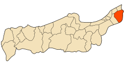 Koléa District highlighted in Tipaza Province | |
 Koléa Location of Koléa in Algeria | |
| Coordinates: DZ 36°38′26″N 2°45′54″E / 36.64056°N 2.76500°ECoordinates: DZ 36°38′26″N 2°45′54″E / 36.64056°N 2.76500°E | |
| Country | Algeria |
| province | Tipaza |
| District | Koléa |
| Population | |
| • Total | 40,000 |

Kolea is a city in West Algiers Province, northern Algeria, located approximately 20 miles (32 km) southwest of Algiers. It lies on the southern, inland slopes of the coastal hills overlooking the valley of Wadi Mazafran and the Mitidja plain and has a current population of approximately 40,000.
History
Kolea was founded in the 1550 by Barbarossa, Admiral of the Ottoman Navy and Pasha of Algiers, and originally settled by Andalusian Moors. Its name in Arabic means "little fort".
French Presence
Kolea was held by Abdelkader's forces against the French from 1832 until the former were subdued in 1843. Destroyed by an earthquake in 1825, the town was rebuilt along French lines. The 17th-century mosque of Sidi Embarek was converted into a hospital, but the adjoining qubbah, or shrine, has remained an important place of Muslim pilgrimage. The town is noted for handmade embroidery and lace.
In 1838, Lamoricère moved there with his regiment of Zouaves and built four forts: at Fouka, Tombourouf, Ben Azzouz, and Mokta-Khera.
External links
Capital: Tipaza | ||
| Districts |  | |
| Communes | ||