Kokry
| Kokry | |
|---|---|
| Commune and village | |
|
Farmland in the river area | |
 Kokry Location in Mali | |
| Coordinates: 13°57′38″N 5°30′55″W / 13.96056°N 5.51528°WCoordinates: 13°57′38″N 5°30′55″W / 13.96056°N 5.51528°W | |
| Country |
|
| Region | Ségou Region |
| Cercle | Macina Cercle |
| Area[1] | |
| • Total | 160 km2 (60 sq mi) |
| Population (2009 census)[2] | |
| • Total | 13,393 |
| • Density | 84/km2 (220/sq mi) |
| Time zone | GMT (UTC+0) |
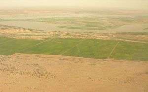
Kokry is a village and rural commune in the Cercle of Macina in the Ségou Region of southern-central Mali. The commune covers an area of approximately 160 square kilometers and includes 17 villages.[3] The farmland is irrigated by the Office du Niger irrigation scheme. The main crop is rice. In the 2009 census the commune had a population of 13,393.[2] The main village, (chef-lieu), is called Kokry Centre to distinguish it from Kokry Bozo which lies 3 km to the east on a strip of land between the Niger River and the Distributeur Kokry, an irrigation canal.
References
- ↑ "Common and Fundamental Operational Datasets Registry: Mali", United Nations Office for the Coordination of Humanitarian Affairs http://cod.humanitarianresponse.info/country-region/mali Missing or empty
|title=(help). commune_mali.zip (Originally from the Direction Nationale des Collectivités Territoriales, République du Mali) - 1 2 Resultats Provisoires RGPH 2009 (Région de Ségou) (PDF) (in French), République de Mali: Institut National de la Statistique.
- ↑ Communes de la Région de Ségou (PDF) (in French), Ministère de l’administration territoriale et des collectivités locales, République du Mali.
External links
- Plan de Sécurité Alimentaire Commune Rurale de Kokry 2007-2011 (PDF) (in French), Commissariat à la Sécurité Alimentaire, République du Mali, USAID-Mali, 2007.

This article is issued from Wikipedia - version of the 9/2/2012. The text is available under the Creative Commons Attribution/Share Alike but additional terms may apply for the media files.