Koili
| Koili Κοίλη | |
|---|---|
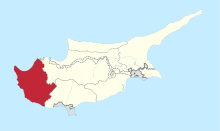
 Koili Location in Cyprus | |
| Coordinates: 34°51′36″N 32°27′18″E / 34.86000°N 32.45500°ECoordinates: 34°51′36″N 32°27′18″E / 34.86000°N 32.45500°E | |
| Country |
|
| District | Paphos District |
| Elevation | 1,916 ft (584 m) |
| Population (2001)[1] | |
| • Total | 333 |
| Time zone | EET (UTC+2) |
| • Summer (DST) | EEST (UTC+3) |
| Postal code | 6121 |
Koili (Greek: Κοίλη) is a village in the Paphos District of Cyprus, located 2 kilometres (1.2 mi) northwest of Tsadha.
References
This article is issued from Wikipedia - version of the 11/8/2015. The text is available under the Creative Commons Attribution/Share Alike but additional terms may apply for the media files.