Königslutter
| Königslutter | ||
|---|---|---|
|
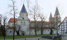
Old town and monastery church (Kaiserdom) | ||
| ||
 Königslutter | ||
| Coordinates: 52°15′N 10°49′E / 52.250°N 10.817°ECoordinates: 52°15′N 10°49′E / 52.250°N 10.817°E | ||
| Country | Germany | |
| State | Lower Saxony | |
| District | Helmstedt | |
| First mentioned | 1135 | |
| Government | ||
| • Mayor | Alexander Hoppe (SPD) | |
| Area | ||
| • Total | 130.58 km2 (50.42 sq mi) | |
| Population (2015-12-31)[1] | ||
| • Total | 15,733 | |
| • Density | 120/km2 (310/sq mi) | |
| Time zone | CET/CEST (UTC+1/+2) | |
| Postal codes | 38154 | |
| Dialling codes | 05353 | |
| Vehicle registration | HE | |
| Website | www.koenigslutter.de | |


Königslutter am Elm is a town in the district of Helmstedt in Lower Saxony, Germany.
Geography
It is located on the northeastern slopes of the Elm hill range, within the Elm-Lappwald Nature Park, about 23 km (14 mi) east of Brunswick, 15 km (9.3 mi) west of the district capital Helmstedt, and 20 km (12 mi) south of Wolfsburg.
The town has access to the Brunswick–Magdeburg railway at the Königslutter railway station, served by Regionalbahn trains to Brunswick and Helmstedt, and is traversed by the Bundesstraße 1 federal highway. The Bundesautobahn 2 runs about 6 km (3.7 mi) north of the town centre. Königslutter is a stop on the German Timber-Frame Road (Deutsche Fachwerkstraße) tourist route.
In its current form, the township with about 16,000 inhabitants was created in a 1974 administrative reform by joining the following 18 municipalities:
- Beienrode
- Boimstorf
- Bornum am Elm
- Glentorf
- Groß Steinum
- Klein Steimke
- Königslutter
- Lauingen
- Lelm
- Ochsendorf
- Rhode
- Rieseberg
- Rotenkamp
- Rottorf
- Scheppau
- Schickelsheim
- Sunstedt
- Uhry
History

A village called Lûtere in the Duchy of Saxony was first mentioned in a 1135 deed, when Emperor Lothair III established a Benedictine monastery here, centered on the Sts Peter and Paul Church, a prominent Romanesque basilica where he and his consort Richenza of Northeim as well as his son-in-law, the Welf duke Henry the Proud are also buried. The place was named after the nearby karst spring of the Lutter (from Middle High German: lauter, "pure") stream in the Elm hills.
A water castle was erected around 1200 and in 1318 the surrounding settlement was documented as a market town. Around 1400 the Dukes of Brunswick granted the citizens of Luttere town privileges. From the late 14th century onwards, the place was called Konnigesluttere, referring to late Emperor Lothair III, King of the Romans.
Located on the trade route from Brunswick to Magdeburg (the present-day Bundesstraße 1), beer brewing and Elm limestone mining and cutting were its main industries in early modern times, while the monastery developed as a pilgrimage destination. Not until 1924, the monastery complex and the adjacent settlement of Oberlutter were incorporated into the town. The monastery church is known for its sculptural art and the tomb of the emperor.
Politics
Seats in the town's assembly (Rat) as of 2011 local elections:
- Christian Democratic Union (CDU): 15
- Social Democratic Party of Germany (SPD): 14
- Free Voters: 2
- Free Democratic Party (FDP): 1
- Alliance 90/The Greens: 1
In 2013 the assembly has voted to enter in merger negotiations with neighbouring Wolfsburg.
Twin towns
Königslutter is twinned with the following towns:
Notable people
- Werner Schrader (1895–1944), officer and Resistance fighter
- Samuel Hahnemann (1755–1843), physician and pioneer of homeopathy, who lived in Königslutter from 1796 to 1799
- Thilo Maatsch (1900–1983), Bauhaus artist, spent his retirement here
Notes
External links
| Wikimedia Commons has media related to Königslutter am Elm. |
![]() Koenigslutter travel guide from Wikivoyage
Koenigslutter travel guide from Wikivoyage
 "Königslutter". Encyclopædia Britannica. 15 (11th ed.). 1911.
- Official site
Towns and municipalities in Helmstedt (district) | ||
|---|---|---|