Kochi Metropolitan Area
| Kochi Metropolitan Area കൊച്ചി നഗരസമൂഹം Greater Cochin | |
|---|---|
| Urban Agglomeration | |
|
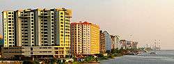
Ernakulam Mainland, as seen from the Vembanad Lake | |
| Country |
|
| State | Kerala |
| District | Ernakulam |
| Population (2014)[1] | |
| • Total | 2,277,630 |
| Languages | |
| • Official | Malayalam, English |
| Time zone | IST (UTC+5:30) |
| Telephone code | 0484 |
| Vehicle registration | KL-7, KL-17, KL-39, KL-40, KL-41, KL-42, KL-43, KL-44, KL-63 |
The Kochi Urban Agglomeration (Kochi UA) is an urban agglomeration centred around the city of Kochi.
Location
Kochi Urban Agglomeration is part of the Greater Cochin region and the largest urban agglomeration in Kerala, India.[2]
Municipalities and Panchayaths
The area constituted on the basis of census data 2011, consists of Corporation of Kochi (Cochin), 9 municipalities, 14 Panchayaths and parts of 4 Panchayaths. The 9 municipalities are Thrippunithura, Maradu, Thrikkakara, Kalamassery, Eloor, North Paravur, Perumbavoor, Aluva and Angamali. The fourteen Panchayaths consists of Cheranelloor, Varapuzha, Chennamangalam, Kadamakkudy, Mulavukad, Kadungalloor, Alengad, Chengamanad, Nedumbassery, Chottanikkara, Choornikkara, Edathala, Kumbalam, Kottuvally and Vypin Island. .
Apart from these local body areas, the Census Towns (CT) of Kureekad, Chowwara, Cheriyakadavu and Kedamangalam are also part of the Kochi Urban Agglomeration. Urban ugglomerations in India are determined on the basis of Census Towns (CT) which may or may not coincide with local bodies like Corporations, Municipalities or Panchayaths. E.g., Thrikkakara Municipality is enumerated as Census Towns of Kakkanad and Vazhakkala. Kochi urban agglomeration itself is not a geographically contiguous entity.
The state government and the GCDA have plans to include Mala and Kodungallur in Thrissur district; Angamaly, Perumbavoor, Piravom and Kolenchery, in Ernakulam district; Thalayolaparambu and Vaikom in Kottayam; and Cherthala in Alappuzha district within the Kochi metropolitan limits. The newly formed metropolis would be put under the charge of a new authority called Kochi Metropolitan Regional Development Authority.
Demographics
As per Census 2011, it has a population of 2,117,990 making it the largest[2] urban agglomeration in Kerala.[1]
History
Kochi was the princely state under the Kingdom of Kochi which came into existence in 1102, after the fall of the Kulasekhara empire.[6] The princely state was having the Kochi mainland as the capital. The state was ruled by Cochin Royal Family. However, the kingdom was under foreign rule since the 18th century, and the King often only had titular privileges.
On the earlier days, the kingdom of Kochi was always under the shadow of the attacks from Samoothirippadu (often anglicised as Zamorin), the ruler of Malabar the northern neighbour. From 1503 to 1663, Kochi was ruled by Portugal. Kochi hosted the grave of Vasco da Gama, the first European explorer to set sail for India, who was buried at St. Francis Church until his remains were returned to Portugal in 1539.[7] The Portuguese rule was followed by that of the Dutch, who had allied with the Zamorins in order to conquer Kochi.
In the battle of Ambalapuzha (3 January 1754), the Dutch allied Kochi was defeated by Marthanda Varma of Travancore after he ousted the Dutch in the Battle of Colachel-1741. In 1757 AD, a treaty was concluded between Travancore and Cochin, ensuring peace and stability on the Southern border. By 1773, the Mysore King Hyder Ali extended his conquest in the Malabar region to Kochi, forcing it to become a tributary of Mysore. The hereditary Prime Ministership of Kochi held by the Paliath Achans came to an end during this period. Soon, Kochi was ceded to the United Kingdom by the Dutch, who feared an outbreak of war on the Dutch Republic signed a treaty with the United Kingdom. This was in exchange for the island of Bangka as per the treaty.[8] Kochi was thus under the British rule, till India gained independence in 1947.
In 1949, Travancore-Cochin state came into being with the merger of Cochin and Travancore. The King of Travancore was the Rajpramukh of the Travancore-Cochin Union from 1949 to 1956. Travancore-Cochin, was in turn merged with the Malabar district of the Madras State. Finally, the Government of India's States Reorganisation Act (1956) inaugurated a new state Kerala; incorporating Travancore-Cochin (excluding the four southern Taluks which were merged with Tamil Nadu), Malabar District, and the taluk of Kasargod, South Kanara.
Kochi Urban Agglomeration was defined in 1998, with the corporation of Cochin, municipalities of North Paravur Aluva, Angamaly, Kalamassery and 11 adjoining villages.
Economy


| Kochi Urban Agglomeration population | |||
|---|---|---|---|
| Census | Pop. | %± | |
| 1981 | 824,900 | — | |
| 1991 | 1,140,600 | 38.3% | |
| 2001 | 1,536,400 | 34.7% | |
| 2011 | 2,117,990 | 37.9% | |
| Source: Census of India[9] | |||
Kochi UA is referred to as the economic capital of Kerala. As a major coastal city which acts a gateway to goods in India, it has helped the development of the city
The economic growth gathered momentum after economic reforms in India introduced by the central government in the mid-1990s. Since 2000, the service sector has energized the economy. Over the years, the city has witnessed rapid commercialisation, and has today grown into the commercial capital of Kerala.[10]
Constituents of the urban agglomeration
| Place | Classification | 2001 population | Area (km2) | ||||
|---|---|---|---|---|---|---|---|
| Angamaly | Municipality | 33,424 | 24.0 | ||||
| Chengamanad | Census town | 29,775 | 15.6 | ||||
| Chowwara | Census town | 13,603 | |||||
| Aluva | Municipality | 24,108 | 7.2 | ||||
| Choornikkara | Census town | 36,998 | 11.0 | ||||
| Edathala | Census town | 67,137 | 16.0 | ||||
| Paravur | Municipality | 30,056 | 9.0 | ||||
| Kottuvally | Census town | 37,884 | 20.8 | ||||
| Varappuzha | Census town | 24,516 | 7.7 | ||||
| Eloor | Municipality | 30,092 | 14.2 | ||||
| Kadungalloor | Municipality | 35,451 | 18.1 | ||||
| Mulavukad | Census town | 22,845 | 19.3 | ||||
| Kadamakkudy | Census town | 15,823 | 12.9 | ||||
| Cheranallur | Census town | 26,330 | 10.6 | ||||
| Kalamassery | Municipality | 63,176 | 27.0 | ||||
| Vazhakkala | Census town | 42,272 | 19.6 | ||||
| Vypin | Census town | 200,238 | 87.85 | ||||
| Kochi | Municipal corporation | 596,473 | 94.9 | ||||
| Kedamangalam | Outgrowth | 21,729 | 42.7 | ||||
| Alangad | Outgrowth | 40,585 | 18.4 | ||||
| Cheriyakadavu | Outgrowth | 8,326 | |||||
| Thrikkakkara | Municipality | 22,486 | 42.8 | ||||
| Maradu | Municipality | 40,993 | 12.4 | ||||
| Thrippunithura | Municipality | 81,594 | 29.2 | ||||
| Chennamangalam | Outgrowth | 21,881 | 14.7 | ||||
| Chottanikkara | Census town | 19,168 | 17.3 | ||||
| Kureekkad | Census town | 9,730 | |||||
| Perumbavoor | Municipality | 64,545 | 28.5 | TOTAL | 1,546,470 | ≈600 | |
References
- 1 2 "Urban Agglomerations/Cities having population 1 million and above" (PDF). The Registrar General & Census Commissioner, India. Retrieved 16 October 2011.
- 1 2 "Govt of Kerala, CDP Kochi". Retrieved 7 May 2015.
- ↑ "Corporation of Cochin - Appraisal Report, JNNURM, Govt. of India" (PDF).
- ↑ Ernakulam District Administration http://ernakulam.nic.in/census.htm. Missing or empty
|title=(help) - ↑ "Achieving compact and high-density development". The Hindu. Chennai, India. 1 October 2005.
- ↑ Kochi Kingdom Corporation of Cochin official site
- ↑ Vasco-Da-Gama Encarta encyclopedia. Archived 2009-11-01.
- ↑ "HISTORY OF BANGKA ISLAND".
- ↑ "TABLE 7.2.11". mospi.gov.in. Retrieved 23 June 2008.
- ↑ Statistics of Ernakulam in 2001 Official site of Government of Kerala
External links