Knipescar Common
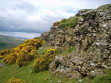
Knipescar Common, or Knipe Scar, is an upland area in the east of the English Lake District, above the River Lowther, near Bampton, Cumbria. It is the subject of a chapter of Wainwright's book The Outlying Fells of Lakeland.[1] The summit is "indefinite" but reaches 1,118 feet (341 m) and there are limestone outcrops and an ancient enclosure. Wainwright commends the views which include Blencathra to the north and "a continuous skyline of the higher Pennines."
Two ring cairns are scheduled monuments.[2][3] The more northerly is the "ancient enclosure" described by Wainwright.[4]
Immediately to the east of the southern part of Knipescar Common lies Shap Beck Quarry, an active limestone quarry.[5]
References
- ↑ Wainwright, A. (1974). "Knipescar Common". The Outlying Fells of Lakeland. Kendal: Westmorland Gazette. pp. 220–223.
- ↑ Historic England. "Ring cairn on Knipescar Common (1007407)". National Heritage List for England. Retrieved 21 June 2015.
- ↑ Historic England. "Ring cairn on Knipescar Common south of Inscar Plantation (1007364)". National Heritage List for England. Retrieved 21 June 2015.
- ↑ Wainwright, A. (1974). "Knipescar Common". The Outlying Fells of Lakeland. Kendal: Westmorland Gazette. p. 222.
The ancient enclosure, indicated on some maps as a Stone Circle and formerly referred to locally as a Druids Circle...
- ↑ "Shap Quarries". Visit Cumbria. Retrieved 21 June 2015.
Coordinates: 54°33′55″N 2°44′02″W / 54.56528°N 2.73389°W