Kloof
| Kloof | |||
|---|---|---|---|
|
Kloof suburbs from Krantzkloof heights | |||
| |||
 Kloof  Kloof  Kloof
| |||
|
Location within Durban 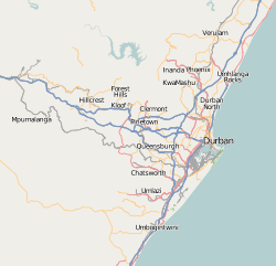 Kloof | |||
| Coordinates: 29°47′S 30°50′E / 29.783°S 30.833°ECoordinates: 29°47′S 30°50′E / 29.783°S 30.833°E | |||
| Country | South Africa | ||
| Province | KwaZulu-Natal | ||
| Municipality | eThekwini | ||
| Established | 1903 | ||
| Government | |||
| • Mayor | Obed Mlaba | ||
| Area[1] | |||
| • Total | 34.51 km2 (13.32 sq mi) | ||
| Population (2011)[1] | |||
| • Total | 29,704 | ||
| • Density | 860/km2 (2,200/sq mi) | ||
| Racial makeup (2011)[1] | |||
| • Black African | 53.8% | ||
| • Coloured | 0.7% | ||
| • Indian/Asian | 11.2% | ||
| • White | 33.8% | ||
| • Other | 0.4% | ||
| First languages (2011)[1] | |||
| • English | 45.1% | ||
| • Zulu | 43.9% | ||
| • Xhosa | 3.6% | ||
| • Afrikaans | 3.4% | ||
| • Other | 4.1% | ||
| Postal code (street) | 3610 | ||
| PO box | 3640 | ||
| Area code | 031 | ||


Kloof is a leafy upper-class suburb and small town, that includes a smaller area called Everton, in the greater Durban area of eThekwini in KwaZulu-Natal, South Africa.
The word Kloof (cf. cleft) means 'gorge' in Afrikaans and the area is named after the deep ravine formed by the Molweni stream (stream of high cliffs). The Kloof Gorge is part of the 4.47-square-kilometre (1.73 sq mi) Krantzkloof Nature Reserve.
Kloof extends from the top of Field's Hill and borders Winston Park, Gillitts, Forest Hills and Hillcrest. These suburbs are collectively known as the Upper Highway Area or the Outer West region of Durban.
The M13 highway (built in the 1940s) intersects Kloof and on 16 June this forms part of the route of the annual Comrades Marathon, an approximately 90 kilometres (56 mi) ultra-marathon run between Pietermaritzburg and Durban since 1924.
It is a predominantly English-speaking area. Kloof features several upmarket shopping centres and the Kloof Country Club, founded in 1927. It is known as a mist-belt with winding roads and tree-surrounded mansions.
History
Details of the history of Kloof has been written by Rowe.[2]
Richmond Farm
This part of KwaZulu-Natal was originally a 6,000 acres (2,400 ha) farm 'Richmond', whose survey was ordained by the first Lieutenant-Governor of Colony Sir Martin West, following his 1845 appointment to the post; he also named it, after Charles Lennox, 4th Duke of Richmond (Yorkshire, England).
The land Kloof occupies formed the 2,836 hectares (7,010 acres) Richmond Farm No. 999: this was given to William Swan FIELD by the British Government in 1851 as reward for his services as First Collector of Customs (position he held until 1852) for Natal Colony, and as First Magistrate of Durban. In 1852 he settled brother John Coote FIELD and his family on the farm, having had them brought up from the Cape Colony. The farm was eventually transferred into J C Field's name by Deed of Transfer in 1867, at a declared value of 1,401 pounds & 10 shillings.
The original farmhouse, called Richmond House, was built by J C Field in 1854 to replace an earlier house. The 'Richmond' section of the farm passed to his son John Coote FIELD the Second in 1880 on the occasion of his marriage, who partially demolished the original Richmond House and rebuilt another homestead nearby.
J C Field the First died in 1896, and upon the death of his widow in 1901 the Farm was divided amongst the surviving heirs: 560 acres (230 ha) for each son, 395 acres (160 ha) for each daughter, and the homestead plus 500 acres (200 ha) to his youngest son Benjamin Cromwell Colenso FIELD.
Kloof village
The further subdivisions and sale of portions of Richmond Farm No. 999 by the Field heirs after 1901 resulted in the birth of Kloof as a residential area: numerous plots were sold to wealthy Durban residents and businessmen, who built country house retreats close to the city, but (due to its 550 m above sea level elevation) removed from the Durban humidity and heat. These were particularly favoured by their wives and children during the long hot summer holidays.
From the 1890s onwards the appearance of the area therefore changed significantly, from its previous 'sandstone sourveld' grassland to its current heavily-wooded flora.
Kloof was originally called 'Krantzkloof' by J C Field the First, after the nearby Kloof Gorge, but this name was later changed to 'Kloof' at the special request of the General Manager of the Railways, since due to a name similarity with Kranskop there had been significant confusion and misdeliveries of railway goods: the Railway Station was therefore renamed, and the town with it. The current Station building is a replacement of an earlier one, built in 1896, and it remained operational until the closure of this branch of the Durban-Pietermaritzburg railway line to passenger traffic in the 1970s. The building is now being utilised as a popular bar restaurant; it is also the main terminus of the Umgeni Steam Railway.
As roads improved, an increasing number of people began permanently living in Kloof and during the 1960s and 1970s, the development of the traditional Kloof houses occurred. These consisted of large houses that were built on stands of at least 1 acre (0.40 ha). Many of the houses have slate roofs, a swimming pool, small guest houses and tennis courts and they are often tucked away amidst the trees.
Schools
Kloof has a state school network that consists of Kloof High School, Forest View Primary School, Kloof Senior Primary School, Kloof Junior Primary School and Kloof Pre-Primary School.
There are also several private schools located in Kloof including Thomas More College and St Mary's Diocesan School for Girls. In the broader area there is also Highbury Preparatory School in Hillcrest and Kearsney College in Botha's Hill.
Wildlife
The many trees that define Kloof provide for an abundance of birds, including the Crowned eagle.
Other wildlife has been preserved in greenbelt areas such as the Krantzkloof Nature Reserve, which includes the Kloof Gorge, and the Everton Conservancy. The Reserve is centered on the main gorge cut by the eMolweni River, and extends in total 532 ha (1,315 ac). It was established by the Natal Parks Board in 1950.
The area around the gorge was once the habitat of leopards and a leopard features prominently on the Kloof crest. (The stuffed leopard in the Durban Museum reportedly was shot in the area). Chacma baboon were once re-introduced to the reserve, but unfortunately, after becoming troublesome, were removed. Bushpig may also be found in the reserve. Both would likely have formed part of the diet of the leopard.
Climate
Average yearly rainfall is 1,075 millimetres (42.3 in), based on records which date back to 1935. The rainy season is from the October to March summer months, while winters tend to be very dry.
Summer temperatures range from 18–32 °C (64–90 °F), with winter temperatures between 8–20 °C (46–68 °F).
Botanical gardens
Private botanical gardens which were established by a well-known horticulturalist are now the gardens of a hotel known as the Makaranga Lodge after tall trees planted in the gardens. Visitors are able to arrange guided tours.
The golf course
The Kloof Country Club includes a highly rated 18-hole golf course, which was the only golf course outside of Durban for many years. The M13 highway runs parallel to it.
Places of interest

The Kranztview Nature Reserve is also home to popular rock climbing routes which are used by beginners and experts. It is one of the stomping grounds of sport and traditional rock climbing and if you are more of a spectator, the gorge has easily accessible hiking trails that lead to breath-taking views.
Shopping
- Delcairn Centre
- Field's Shopping Centre
- Maytime Shopping Centre
- The Village Mall
Activity centres
- Kloof Country Club (golf course, tennis and squash courts, cricket oval, and facilities)
- Krantzkloof Nature Reserve and Kloof Gorge
- Kloof Methodist Church
- Kloof Tennis Club
- St. Agnes Anglican Church, the church building, dating from the 1950s, was built on a piece of land on the farm section 'Glenholm', owned by T. S. P. Field and donated by him to the Anglican Diocese of Natal.
- Our Lady of Mercy Catholic Church
- Virgin Active gym (formerly Health & Racquet Club)
- Kloof Harvest Church
Famous residents: past and present
- Ladysmith Black Mambazo
- Peter Brown, politician
- Sir William Firth
- Sir Guy Hulett, sugar baron
- Marguerite Poland, author
- Bobby Skinstad, Springbok rugby player
- BJ Botha, Springbok rugby player
- Mike Hoare, Irish mercenary
- Alan Paton, writer and leader of the Liberal Party of South Africa in the 1960s and 1970s
- Simon Lessing, world triathlon champion
- Wally Hammond England and Gloucester cricketer died in Kloof 1 July 1965
References
Sources
- Rowe, Adrian M. (13 May 2003). "A History of Kloof". Keep Kloof Beautiful Association. Retrieved 2015-07-29.
- The Highway Mail, 1 June 2011.
- The Hilltop, 2 June 2011.
- Independent Electoral Commission (South Africa), 9 June 2011.
External links
- Kloof Community Website
- Kloof Pre-Primary School Website
- Kloof Junior Primary School Website
- Kloof Senior Primary School Website
- Kloof High School Website
- Krantzkloof Nature Reserve Website
- Kloof Conservancy Website
- Official Councillor Website
- Rotary Club of Kloof
- Our Lady of Mercy Catholic Parish
Communities of eThekwini Metropolitan Municipality, KwaZulu-Natal | |||||||||||||||
|---|---|---|---|---|---|---|---|---|---|---|---|---|---|---|---|
Seat: Durban | |||||||||||||||
| Cities and towns |
| .svg.png) | |||||||||||||
| Suburbs of Durban |
| ||||||||||||||