Klamath, California
| Klamath | |
|---|---|
| census-designated place | |
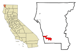 Location in Del Norte County and the state of California | |
 Klamath Location in the United States | |
| Coordinates: 41°31′35″N 124°02′18″W / 41.52639°N 124.03833°WCoordinates: 41°31′35″N 124°02′18″W / 41.52639°N 124.03833°W | |
| Country |
|
| State |
|
| County | Del Norte |
| Area[1] | |
| • Total | 12.541 sq mi (32.480 km2) |
| • Land | 12.541 sq mi (32.480 km2) |
| • Water | 0 sq mi (0 km2) 0% |
| Elevation | 30 ft (9 m) |
| Population (2010) | |
| • Total | 779 |
| • Density | 62/sq mi (24/km2) |
| Time zone | Pacific (PST) (UTC-8) |
| • Summer (DST) | PDT (UTC-7) |
| ZIP code | 95548 |
| Area code(s) | 707 |
| FIPS code | 06-38702 |
| GNIS feature ID | 0277534 |
| U.S. Geological Survey Geographic Names Information System: Klamath, California | |

Klamath (Tolowa: taa-chit [3]) is an unincorporated, rural, census-designated place (CDP) in Del Norte County, California, situated on US Route 101 inland from the mouth of the Klamath River. The population was 779 at the 2010 census, up from 651 at the 2000 census. Klamath is at an elevation of 30 feet (9 m).
The original "town" center was destroyed by the 1964 Flood. Streets and sidewalks of this original site, west of US 101 and the current site of the town's core, remain visible.
Geography
According to the United States Census Bureau, the CDP has a total area of 12.5 square miles (32 km2), all of it land.
Climate
This region experiences warm (but not hot) and dry summers, with no average monthly temperatures above 71.6 °F. According to the Köppen Climate Classification system, Klamath has a warm-summer Mediterranean climate, abbreviated "Csb" on climate maps.[4]
| Climate data for Klamath | |||||||||||||
|---|---|---|---|---|---|---|---|---|---|---|---|---|---|
| Month | Jan | Feb | Mar | Apr | May | Jun | Jul | Aug | Sep | Oct | Nov | Dec | Year |
| Record high °F (°C) | 75 (24) |
80 (27) |
81 (27) |
86 (30) |
91 (33) |
98 (37) |
89 (32) |
93 (34) |
95 (35) |
90 (32) |
78 (26) |
72 (22) |
98 (37) |
| Average high °F (°C) | 54.4 (12.4) |
56.3 (13.5) |
56.7 (13.7) |
58.5 (14.7) |
61.8 (16.6) |
64.8 (18.2) |
66.3 (19.1) |
66.7 (19.3) |
67.2 (19.6) |
64.2 (17.9) |
58.6 (14.8) |
54.6 (12.6) |
60.8 (16) |
| Average low °F (°C) | 38.4 (3.6) |
39.6 (4.2) |
40.1 (4.5) |
42 (6) |
45.4 (7.4) |
49.1 (9.5) |
51.6 (10.9) |
52.2 (11.2) |
49.8 (9.9) |
46 (8) |
42.1 (5.6) |
38.7 (3.7) |
44.6 (7) |
| Record low °F (°C) | 18 (−8) |
19 (−7) |
24 (−4) |
27 (−3) |
24 (−4) |
33 (1) |
34 (1) |
36 (2) |
24 (−4) |
28 (−2) |
22 (−6) |
16 (−9) |
16 (−9) |
| Average precipitation inches (mm) | 13.86 (352) |
10.79 (274.1) |
10.51 (267) |
5.72 (145.3) |
3.63 (92.2) |
1.42 (36.1) |
0.32 (8.1) |
0.73 (18.5) |
1.71 (43.4) |
5.66 (143.8) |
11.68 (296.7) |
14.05 (356.9) |
80.09 (2,034.3) |
| Average snowfall inches (cm) | 0.4 (1) |
0.4 (1) |
0.1 (0.3) |
0 (0) |
0 (0) |
0 (0) |
0 (0) |
0 (0) |
0 (0) |
0 (0) |
0 (0) |
0.1 (0.3) |
1.1 (2.8) |
| Average precipitation days | 17 | 15 | 16 | 12 | 8 | 5 | 2 | 2 | 4 | 8 | 15 | 17 | 121 |
| Source: [5] | |||||||||||||
Notable residents
- Tom Darby – American journalist, Nevada Broadcast Hall of Fame inductee, author and blogger. He currently lives in Spanish Springs, Nevada.
Demographics
2010
The 2010 United States Census[6] reported that Klamath had a population of 779. The population density was 62.1 people per square mile (24.0/km²). The racial makeup of Klamath was 379 (48.7%) White, 1 (0.1%) African American, 325 (41.7%) Native American, 3 (0.4%) Asian, 0 (0.0%) Pacific Islander, 5 (0.6%) from other races, and 66 (8.5%) from two or more races. Hispanic or Latino of any race were 90 persons (11.6%).
The Census reported that 775 people (99.5% of the population) lived in households, 4 (0.5%) lived in non-institutionalized group quarters, and 0 (0%) were institutionalized.
There were 307 households, out of which 83 (27.0%) had children under the age of 18 living in them, 107 (34.9%) were opposite-sex married couples living together, 37 (12.1%) had a female householder with no husband present, 30 (9.8%) had a male householder with no wife present. There were 38 (12.4%) unmarried opposite-sex partnerships, and 5 (1.6%) same-sex married couples or partnerships. 94 households (30.6%) were made up of individuals and 35 (11.4%) had someone living alone who was 65 years of age or older. The average household size was 2.52. There were 174 families (56.7% of all households); the average family size was 3.20.
The population was spread out with 183 people (23.5%) under the age of 18, 53 people (6.8%) aged 18 to 24, 168 people (21.6%) aged 25 to 44, 231 people (29.7%) aged 45 to 64, and 144 people (18.5%) who were 65 years of age or older. The median age was 43.1 years. For every 100 females there were 107.2 males. For every 100 females age 18 and over, there were 109.9 males.
There were 406 housing units at an average density of 32.4 per square mile (12.5/km²), of which 173 (56.4%) were owner-occupied, and 134 (43.6%) were occupied by renters. The homeowner vacancy rate was 3.9%; the rental vacancy rate was 8.8%. 398 people (51.1% of the population) lived in owner-occupied housing units and 377 people (48.4%) lived in rental housing units.
2000
As of the census[7] of 2000, there were 651 people, 264 households, and 177 families residing in the CDP. The population density was 51.9 people per square mile (20.0/km²). There were 365 housing units at an average density of 29.1 per square mile (11.2/km²). The racial makeup of the CDP was 58.37% White, 34.25% Native American, 0.77% Asian, 2.15% from other races, and 4.45% from two or more races. 5.53% of the population were Hispanic or Latino of any race.
There were 264 households out of which 25.8% had children under the age of 18 living with them, 48.5% were married couples living together, 11.4% had a female householder with no husband present, and 32.6% were non-families. 27.3% of all households were made up of individuals and 10.2% had someone living alone who was 65 years of age or older. The average household size was 2.39 and the average family size was 2.83.
In the CDP the population was spread out with 24.4% under the age of 18, 8.6% from 18 to 24, 21.8% from 25 to 44, 24.4% from 45 to 64, and 20.7% who were 65 years of age or older. The median age was 41 years. For every 100 females there were 110.7 males. For every 100 females age 18 and over, there were 104.1 males.
The median income for a household in the CDP was $29,231, and the median income for a family was $29,417. Males had a median income of $24,750 versus $22,500 for females. The per capita income for the CDP was $13,660. About 11.2% of families and 15.2% of the population were below the poverty line, including 13.5% of those under age 18 and 7.9% of those age 65 or over.
Politics
In the state legislature, Klamath is in the 2nd Senate District, represented by Democrat Mike McGuire,[8] and the 2nd Assembly District, represented by Democrat Jim Wood.[9]
Federally, Klamath is in California's 2nd congressional district, represented by Democrat Jared Huffman.[10]
Trivia
- Klamath is often confused with Klamath Falls, Oregon.
- Klamath is located within the Yurok Indian Reservation.
- Salmon fishing was a major component of the local economy. As of late, fish stocks are in decline due to political feuds with upstream agribusiness water users in the Klamath Falls area.
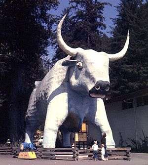
- Klamath has a 35-foot (10-meter) statue of Babe the Blue Ox, the legendary sidekick of Paul Bunyan, a famous mythical lumberjack at Trees of Mystery. On 20 November 2007, the head of the statue fell off. The head has since been repaired.[11]
- Klamath was on the center line of the annular solar eclipse path as it entered North America on Sunday, May 20, 2012. This was the first central land entry on the West Coast. Weather permitting, this location in the USA was best suited to viewing this event because it occurred earlier in the day than further east, and the sun appeared to be higher in the sky. See Solar eclipse of May 20, 2012.
See also
-
 California portal
 - Trees of Mystery
References
| Wikimedia Commons has media related to Klamath, California. |
- ↑ "2010 Census U.S. Gazetteer Files – Places – California". United States Census Bureau.
- ↑ KHV 10
- ↑ "Siletz Talking Dictionary". Retrieved 2012-06-04.
- ↑ Climate Summary for Klamath, California
- ↑ "POINT ARENA, CALIFORNIA (044577)". Western Regional Climate Center. Retrieved November 18, 2015.
- ↑ "2010 Census Interactive Population Search: CA - Klamath CDP". U.S. Census Bureau. Retrieved July 12, 2014.
- ↑ "American FactFinder". United States Census Bureau. Retrieved 2008-01-31.
- ↑ "Senators". State of California. Retrieved April 5, 2013.
- ↑ "Members Assembly". State of California. Retrieved March 2, 2013.
- ↑ "California's 2nd Congressional District - Representatives & District Map". Civic Impulse, LLC. Retrieved March 1, 2013.
- ↑ "Babe loses head, Bunyan not a suspect". Newsvine.com. 24 November 2007. Retrieved 2007-11-26.
Municipalities and communities of Del Norte County, California, United States | ||
|---|---|---|
| City | 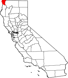 | |
| CDPs | ||
| Unincorporated communities | ||
| Indian reservations | ||
| Ghost towns |
| |
| States and counties |  | |
|---|---|---|
| Significant cities | ||
| Major tributaries | ||
| Geography | ||
| Native American tribes | ||
| History | ||
| Dams and infrastructure |
| |